Military reference books and manuals (2009-2023, Volume 8) - page 28
Intelligence and the Urban Environment
Table 1-5. Example information requirements for populations (continued)
Medical.
Examine local law enforcement abilities and
Infrastructure.
capabilities.
Education.
Enforce export laws.
Government service.
Protect persons, property, and
Religious indoctrination.
environment.
Organization’s agenda or cause.
Interdict illegal aliens.
Influence on the population.
Enforce immigration laws.
Organization’s structure.
Maintain arms control.
Key personnel.
Prevent narcotics traffic and use.
Host government liaisons.
Prevent terrorism.
Organization’s security concerns.
Identify types of identification required or used
Relationships between nongovernmental
in the urban area.
organizations.
National.
Assess the sentiments of the urban population
Passport or visa.
toward the various authorities (examine among
Local.
the various ethnic, racial, class, and
Government service.
factional groups).
Military.
Popular support for the local and national
Driver’s license.
government.
Professional, trade, or union.
Popular support for the government’s
Photo identification cards.
military forces.
- Requirements.
Popular support for the U.S. or
- Offices and locations where issued.
multinational governments.
- Forgeries in use.
Active or passive.
Evaluate air, sea, and land customs
Violent or nonviolent.
procedures.
Criteria that would change posture.
Enforcement.
Popular support for U.S. or multinational
Susceptibility to bribery.
military forces.
Evaluate border crossing procedures.
- Active or passive.
- Checkpoints.
- Violent or nonviolent.
- Foot and vehicle patrols.
- If multinational, posture by country.
- Aircraft.
- Factors that would change local
- Searches.
support.
- Documents.
• Actions U.S. forces could take to gain
- Security.
maximum local support.
- Other.
• Actions to avoid.
POPULATION IMPACTS ON THE MISSION
1-92. Although the population is not a part of the terrain, the populace can impact the mission in both
positive and negative ways. Individuals or groups in the population can be coopted by one side or another to
perform a surveillance and reconnaissance function, performing as moving reconnaissance to collect
information. City residents have intimate knowledge of the city. Their observations can provide information
and insights about intelligence gaps and other activities that help reach an understanding of the
environment. For instance, residents often know about shortcuts through town. They might also be able to
observe and report on a demonstration or meeting that occurs in their area.
1-93. Unarmed combatants operating within the populace or noncombatants might provide intelligence to
armed combatants engaged in a confrontation. This was readily apparent in Mogadishu, where unarmed
combatants with the ability to observe friendly force activities without the threat of being engaged
instructed hidden threat forces on where to fire.
1-94. The presence of noncombatants in a combat zone can lead to restrictive rules of engagement, which
may impact the way in which a unit accomplishes its mission. The population, groups or individuals or
sectors within an urban area can be the target audience of influence activities (such as MISO or threat
psychological operations). Specific individuals may provide a means to approach a specific target audience
when acting as a mouthpiece for an information operation.
23 December 2015
TC 2-91.4
1-23
Chapter 1
1-95. Populations present during urban operations can physically restrict movement and maneuver by
limiting or changing the width of routes. People may assist movement if a group can be used as human
barrier between one combatant group and another. Refugee flows, for example, can provide covert
infiltration or exfiltration routes for members of a force. There may also be unintended restrictions to routes
due to normal urban activities which can impact military operations. For example, movement may be
impeded by normally heavy traffic during rush hours as people head to work or return home. Another
example would be a route that goes through a market in town that is closed to traffic only on market days,
but otherwise normally open to unimpeded traffic flow.
1-96. One of the largest challenges to friendly operations is the portion of the population that supports the
adversary. Even people conducting their daily activities may inadvertently “get in the way” of any type of
operation. For example, curiosity-driven crowds in Haiti often affected patrols by inadvertently forcing
units into the middle of the street or pushing them into a single file. While no harm was inflicted, the unit
was made more vulnerable to sniper and grenade attacks.
1-97. Captured combatants or a well-informed noncombatant can provide valuable intelligence about the
enemy. These individuals can be extremely important to the success of military operations. Information
from these sources, however, must be evaluated for accuracy and reliability before being acted upon. The
person providing the information may be intentionally providing disinformation in order to negatively
impact friendly operations or even simply be intended to manipulate friendly forces into conducting
operations that are aimed at a personal grudge rather than influencing the military situation.
1-98. Strategically, the world audience, as well as its local contingent, can create political, cultural, and
ideological impediments to a mission. Friendly forces must evaluate the local population and its potential
effects on operations based on an understanding of the local culture, norms and behaviors—not on the
accepted standards of the home countries of the friendly forces. Friendly forces can then tailor their
activities to achieve the desired effects while avoiding unintended consequences that could even result in
mission failure.
1-99. The American audience watching events unfold in Vietnam could have been perceived as an
impediment to the U.S. government’s strategy of pursuing its strategic objectives. The cultural differences
apparent when U.S. forces were deployed for Operation Desert Storm could have been an impediment if not
adequately addressed. For instance, a MISO flier produced to encourage a sense of unity among the Arab
populations included pictures of two men holding hands—a sight not common in Western cultures. A flier
designed in accordance with Western standards might not have been as effective.
1-100. Civilian populations can also provide infiltration or exfiltration routes for nonuniformed forces.
These forces operating in any urban terrain can instantly blend into any type of crowd or activity. Threat
forces can be protected from firepower by operating within a neutral group.
INFRASTRUCTURE
1-101. The infrastructure of an urban environment consists of the basic resources, support systems,
communications, and industries upon which the population depends. The key elements that allow an urban
area to function are also significant to operations, especially stability operations. The force that controls the
water, electricity, telecommunications, natural gas, food production and distribution, and medical facilities
will virtually control the urban area. These facilities may not be located within the city’s boundaries. The
infrastructure upon which an urban area depends may also provide human services and cultural and political
structures that are critical beyond that urban area, perhaps for the entire nation.
1-102. A city’s infrastructure is its foundation. It includes buildings, bridges, roads, airfields, ports,
subways, sewers, power plants, industrial sectors, communications, and similar physical structures.
Infrastructure varies from city to city. In developed countries, the infrastructure and service sectors are
highly sophisticated and well integrated. In developing cities, even basic infrastructure may be lacking. To
understand how the infrastructure of a city supports the population, it needs to be viewed as a system of
systems. Each component affects the population, the normal operation of the city, and the potential long-
term success of military operations conducted there.
1-24
TC 2-91.4
23 December 2015
Intelligence and the Urban Environment
1-103. Military planners must understand the functions and interrelationships of these components to
assess how disruption or restoration of the infrastructure affects the population and ultimately the mission.
By determining the critical nodes and vulnerabilities of a city, allied forces can delineate specific locations
within the urban area that are vital to overall operations. Additionally, military planners must initially regard
these structures as civilian places or objects, and plan accordingly, until reliable information indicates they
are being used for a military purpose.
1-104. Much of the analysis conducted for terrain and society can apply when assessing the urban
infrastructure. For example, commanders, staffs, and analysts could not effectively assess the urban
economic and commercial infrastructure without simultaneously considering labor. All aspects of the
society relate and can be used to further analyze the urban work force since they are a sub-element of the
urban society. Similarly, the military aspects of terrain (see table 4-1 on page 4-2) used to evaluate terrain
may also apply to the urban infrastructure, especially considerations of key terrain.
1-105. A city’s infrastructure can directly support the military mission. Local airfields or ports are vital for
sustained operations. Host country medical facilities can become vital when allied casualties are greater
than organic medical capabilities can handle. Their continued functioning can also play a role in
maintaining the good will of the local population. Often, during stability operations, maintaining law and
order (to include prisons) becomes vital to the welfare of the general population. Success in ensuring that
law and order is maintained or reestablishing law and order will directly affect the general population’s
perceptions and possible support for U.S. operations.
TRANSPORTATION
1-106. The transportation network is a critical component of a city’s day-to-day activity. It facilitates the
movement of material and personnel around the city. This network includes roads, railways, subways, bus
systems, airports, and harbors. (See table 1-6 and tables 1-7 through 1-12 on pages 1-27 through 1-34 for
example information requirements associated with a transportation infrastructure.) In modern cities, the
transportation network supports rapid international travel, often via several avenues.
1-107. Developing cities often have little means of public transportation. Foot traffic, livestock, and
bicycles represent main sources of travel in underdeveloped cities and compete for road space with more
modern forms of transportation. Care must be taken not to disrupt the transportation system of a city.
Securing air and seaports is imperative for follow-on forces and supplies, but there are many possible
repercussions of securing all the transportation nodes and stopping all inter- and intra-city movement. While
the U.S. mission may be immediately facilitated, critical needs of the noncombatant populace could go
unmet.
Table 1-6. Example information requirements for transportation infrastructure—airfields
General airfield information
Nonoperational.
Provide airfield location.
Auxiliary.
Provide airfield size.
Identify the controlling authority.
Identify airfield type.
Determine the effect that the suspension of
Civilian.
flight activities of the airfield would have on the
Military.
urban area and urban population.
Joint.
Identify key terrain.
Identify principal use.
Locate blueprints of the airfield and its
Describe the construction.
facilities.
Assess security.
Assess the airfield specifications and layout.
Evaluate access.
Airfield elevation.
Provide status of the airfield.
Runways.
Operational.
Identification.
23 December 2015
TC 2-91.4
1-25
Chapter 1
Table 1-6. Example information requirements for transportation infrastructure—
airfields (continued)
Azimuth.
Flight-line.
Length and width.
Taxiway.
Surface, base, subbase (material,
Terminal building.
thickness, condition).
Assess underground drainage system.
Longitudinal grade.
Location.
Transverse grade.
Condition.
Shoulders, clear areas, overruns (width,
Evaluate the airfield utility system.
transverse, grade and surface material).
Electrical power source.
Lateral safety zones (width, transverse
- Master switch.
slope, obstacles.
- Current characteristics.
End clear zones (length, maximum slope).
- Availability of emergency power.
Approach zones (length, width, glide
- Location of transformers.
slope, obstacles).
Natural gas source.
Condition (ability to support aircraft
Jet starting units or auxiliary power units
weight).
Outline the enemy air defense assets (if any).
Eight-digit grid coordinate for each end of
Type.
runway.
Location.
Evaluate taxiways.
Capabilities and limitations.
Identification.
Determine how the airfield is tied into the
Azimuth.
national or regional integrated air defense
Length and width.
system.
Grade.
Type of node.
Surface, base, subbase (thickness).
- Sector operations center.
Bearing capacity (pounds per square
- Intercept operations center.
inch).
- Fighter airfield.
Shoulder and clear area (width, transverse
- Auxiliary airfield.
grade, surface, obstacles).
Assess the airfield’s daily operating
Turn radii.
procedures.
Condition (ability to support aircraft
Normal operating hours of the airfield.
weight).
Most commonly used approach path.
Evaluate parking and warm-up aprons.
Control procedures.
Number and location.
Primary language used by air traffic control
Total area and individual area.
personnel, ground support personnel,
Description.
back-up personnel.
Total capacity.
Flight schedules of airlines using the
Identify hardstands.
airfield.
Number and location.
Airfield support facilities
Aircraft capacity.
Identify communications facilities.
Description.
Location.
Identify hangars.
Type.
Number and location.
Equipment.
Type and material.
Capabilities and limitations.
Condition.
Identify fuel storage facilities.
Size.
Location.
Door descriptions.
Jet fuel.
Locate terminals.
Aviation gas.
Identify control tower and ground control
Jet oil.
approach (location and eight-digit
Aviation oil.
coordinate).
Lubricants, manifolds, and filters.
Evaluate navigational aids.
Pipelines.
Condition.
Above and below ground storage and
Eight-digit grid coordinate.
capacity.
Identify lighting aids.
Pumps.
Runways.
Fuel trucks.
Table 1-6. Example information requirements for transportation infrastructure—
airfields (continued)
1-26
TC 2-91.4
23 December 2015
Intelligence and the Urban Environment
Identify munitions storage areas.
Determine whether surveillance devices or
Location.
capabilities are deployed.
Type.
Types and locations.
Condition.
Field of coverage and monitoring
Security.
locations.
Explosives that can be handled.
Operating times and frequencies.
Aircraft loading procedures.
Physical security measures.
Identify emergency facilities.
Security lighting.
Location.
Checkpoints.
Type.
Perimeter fences.
Equipment.
Internal fences.
Capabilities and limitations.
Other physical security obstructions.
Identify maintenance facilities.
Other considerations
Identify meteorological support facilities.
Describe new construction at the airfield.
Identify administration buildings.
Locate obstructions to flight.
Identify housing facilities.
Vertical obstructions, not contained in
Type, location, and number.
published data, which pose a threat to
Capability and condition.
helicopters or other aircraft at/under 50
Construction materials.
feet above ground level.
Airfield security
Other obstacles to flight within 5 and 10
Assess ground security forces.
kilometers of the airfield.
Military.
Identify radar systems and associated
Civilian.
equipment.
Table 1-7. Example information requirements for transportation infrastructure—
helicopter landing zones
Assess the landing zone characteristics.
Determine the distance and direction from the
Location.
designated objectives.
Dimensions.
Identify escape and evasion routes.
Landing points.
Pickup points.
Capacity by type of aircraft.
Routes to friendly areas.
Surface material.
Landmarks.
Soil trafficability.
Determine whether the urban area canalizes
Obstacles (existing, reinforcing).
movement to the landing zone.
Slope (direction, degree).
Identify buildings with rooftops that can be
Lighting conditions.
used for helicopter landing zones.
Prevailing winds.
Seasonal variations.
Location.
Thermals or updrafts.
Dimensions.
Altitude above sea level.
Landing points.
Determine the characteristics of the approach
Capacity by type.
and retirement lanes.
Obstacles.
Altitude and heading.
Building entrances (location and number).
Check and control points.
Identify the threats in the vicinity of the
Obstacles.
helicopter landing zone.
Enemy dispositions.
Antiair threat.
Determine the characteristics of the adjacent
- Small arms.
terrain and exits.
- Rocket-propelled grenades.
Dominant buildings and terrain.
- Man-portable air defense systems.
Routes of ingress and egress.
- Surface-to-air missiles (mobile and
Relief and drainage.
fixed).
Obstacles (existing, reinforcing).
- Antihelicopter mines.
Identify landmarks usable as navigation aids.
- Antiaircraft artillery (mobile and fixed).
Obstacles.
23 December 2015
TC 2-91.4
1-27
Chapter 1
Table 1-8. Example information requirements for transportation infrastructure—roadways
Identify the routes in the urban area.
- Width
Highways.
- Slope.
Streets.
- Condition.
Alleys.
Curves.
Trails.
- Location.
Bike paths.
- Radius.
Pedestrian paths.
- Slope.
Identify street patterns.
Bridges.
Rectangular or chessboard.
- Total number of segments.
Rayed.
- Load bearing capacity.
Radial or radial-ring.
- Width.
Contour-forming.
Culverts.
Irregular pattern.
- Location.
Combined pattern.
- Type and number.
Linear pattern.
- Construction material.
Determine the effect of roadway shut down.
Ditches.
Evaluate roadway use.
- Depth.
Traffic patterns.
- Width.
- Side slope.
Rush hour times.
- Condition.
Types.
Median strips or dividers.
Importance to economy.
- Material.
Possible rerouting.
- Width.
Method of traffic control.
- Height.
Verify that the maps correspond with the
- Obstructions.
routes.
- Vegetation.
Analyze critical roadways.
Fords and ferries.
Roadway characteristics.
- Location.
- Width.
- Dimensions.
- Surface material.
Tunnels, underpasses, and snow sheds.
- Base course.
- Location.
- Subgrade material.
- Dimensions.
- Maximum wheel load.
Road parking areas.
- Crown.
- Location.
- Maximum elevation.
- Vehicle capacity.
- Drainage.
- Facilities.
Length.
- Surface materials.
- Kilometers.
Junctions or grade crossings.
- Miles.
- Identification.
Grades.
- Location.
- Location of grades exceeding 7 percent.
Checkpoints and obstacles.
- Maximum grade in percent.
- Location.
Shoulders.
- Determine whether location is favorable
- Material.
for ambush.
1-28
TC 2-91.4
23 December 2015
Intelligence and the Urban Environment
Table 1-9. Example information requirements for transportation infrastructure—
railroads
General railway information.
Ballast and subballast.
Identify the number of trains that run
- Material.
daily.
- Size.
- Condition.
Type.
- Thickness.
- Passenger
Railheads.
- Freight.
- Supply transfer points.
Fuel.
- Characteristics (spurs, sidings, piles of
Direction of travel.
material, wagons, tents, huts, guards, supply
Destinations.
handlers).
Cargo and capacity.
End points.
Rolling stock.
- System.
Types of railcars and carrying capacity.
- Route.
Schedules.
- Segment.
Special equipment.
- Reason for end (change in number of
Determine the effect of railway service
tracks, change in gauge, crossing point,
interruption.
construction type and load-bearing capacity,
Locate key and critical points.
international borders).
Type.
Ties.
Location.
- Material.
- Length.
Choke points.
- Width.
Vulnerabilities.
- Depth.
Locate and describe fixed installations.
- Spacing.
Classification yards.
Ditches.
Service yards.
- Depth.
Freight and loading yards.
- Width.
Passenger stations.
- Side slope.
Freight stations.
- Lining.
Analyze the track specifications and railway
- Conditions.
layout.
- Cross sections.
Total length.
- Structures.
- Urban.
Stations.
- Rural.
- Location.
Type.
-Functions.
- Facilities.
- Gauge.
- Command and control.
- Rails.
- Security.
- Roadway.
Bridges.
- Width.
- Dimensions.
- Spacing.
- Characteristics.
Axle load limit.
Culverts.
Minimum clearances.
- Characteristics.
- Horizontal.
- Dimensions.
- Vertical.
Ferries.
Maximum grades.
- Dimensions.
- Direction of travel.
- Characteristics.
- Location.
Tunnels, underpasses, and snow sheds.
Radius of the tightest curve.
- Characteristics.
- Location.
- Dimensions.
- Radius measurement.
- Mainline junctions.
Roadbed.
- Location.
- Material.
- Identification of connecting lines.
- Total width.
- Switch type.
- Width of shoulders.
Table 1-9. Example information requirements for transportation infrastructure—
23 December 2015
TC 2-91.4
1-29
Chapter 1
railroads (continued)
Crossovers.
Command and control.
- Location.
Water facilities.
- Type switch.
- Location.
Evaluate the railway support facilities.
- Service.
Freight handling facilities.
- Type of storage.
- Location.
Evaluate track maintenance.
- Side loading platforms.
Maintenance and construction standards.
- End loading platforms.
Maintenance schedule.
- Sidings with access roads.
Sections in need of repair.
- Freight sheds.
- Location.
- Turntables (number and diameter or
- Nature of repair.
transfer table length).
- Effort required to repair.
- Cranes (number, type, and capacity).
Planned extensions or improvements.
Repair shops and locomotive terminals.
- Type.
- Location.
- Location.
- Engine house and turntable.
- Characteristics.
Manpower.
Identify signals and train control.
Service facilities.
Location.
Fuel facilities.
Type.
- Location.
Determine whether the railroad follows any
- Type of fuel.
terrain features.
- Storage and capacity.
Roadways.
- Quantity of fuel on hand.
Waterways.
- Method of loading.
Terrain.
Electrical facilities.
Assess the safety and security features of the
- End point of electrified sections.
railroad.
- Power feed.
- Current characteristics.
- Source of power.
Table 1-10. Example information requirements for transportation infrastructure—bridges
Identify general characteristics of the bridge.
Analyze the bridge layout.
Location.
Approaches.
Name and military designation.
Banks.
Structural type.
Bypasses.
General condition.
Abutments and piers.
Obstacle crossed.
Spans.
Significance.
Suspension system.
Bridge specifications.
Intermediate supports.
- Length and width.
Walkways.
- Capacity.
Number of spans.
- Military load classifications.
- Type of control (such as, mechanical or
- Under bridge clearance.
electronic).
- Horizontal and vertical clearance.
- Time required to move.
Determine the result should the bridge be
Characteristics of any movable spans.
destroyed or blocked.
Safety and security features.
Evaluate alternate routes.
Traffic control markings.
Determine the effort required to rebuild the
bridge if destroyed.
1-30
TC 2-91.4
23 December 2015
Intelligence and the Urban Environment
Table 1-11. Example information requirements for transportation infrastructure—subways
Assess the general layout of the subway
Evaluate traffic patterns.
system.
Daily number of passengers.
Determine how the disruption of subway
- Weekday.
service would affect the urban area and urban
- Weekend.
population.
- Holiday.
Evaluate the general condition of the subway
- Rush hour.
system.
Stations that receive the most traffic.
Maintenance.
Evaluate the subway construction.
Safety.
Type.
Security.
- Typical subway near surface with flat
Identify the train schedule.
roof and I-beams for roof and sides,
Provide maps of the system.
supported between tracks with steel bulb-
Actual tracks.
angle columns.
Altered renditions of the lines and stations.
- Flat-roof subway of reinforced between
Copies of subway blueprints.
concrete construction supported between
Determine how the subway is operated and
tracks by steel bulb-angle columns, used
managed.
for short distances.
Evaluate the subway specifications.
- Concrete-lined tunnel of open cutwork
Entrances and exits to the system.
and rock tunnel work.
Pedestrian traffic routes.
- Elevated track on steel via duct.
Stairs, escalators, elevators.
- Cast iron tubes used under water.
Security obstructions (such as, gates and
Layers of the inner subway construction.
turnstiles).
Construction of beams and shafts.
Maintenance and utility tunnels.
Reinforcements that are part of the
Drains.
construction to add support and
Terminals.
waterproofing (such as, hard-burned brick
Tunnels: dimensions and construction.
laid in hot asphalt).
Describe rails.
Soil, rock, or compound that the tunnels
Dimensions.
are cut through.
Construction.
Ventilation system.
Describe trains.
How demolition in the subway would affect
Type.
the urban area (surface structure,
Speed.
subterranean features).
Size and capacity of cars.
Examine the subway security system.
Describe rail bed.
Type of security.
Grade.
Threats.
Subgrade.
Vagrant population (if any) in the subway
Rail embedding: crossover sections and
system.
locations.
- Approximate numbers.
Location of controls.
- Primary locations/concentrations.
Turn and corner locations.
- Emergency response.
Manhole locations.
- Evacuation plan.
Electric source location.
Evaluate the decibel level around the trains.
23 December 2015
TC 2-91.4
1-31
Chapter 1
Table 1-12. Example information requirements for transportation infrastructure—
ports and harbors
General information
Identify turning basins.
Identify the local name and military designation.
Locations.
Identify the port or harbor type.
Dimensions.
Assess the general condition of the port or
Controlling depth.
harbor.
Identify anchorages and free-swinging moors.
Determine the importance of the port or harbor.
Locations.
Identify operating data.
Depth range.
Average tonnage.
Holding ground.
Administration.
Protection afforded.
Labor resources.
Type and number of berths.
Provide the total harbor area in acres.
Identify fixed mooring berths.
Provide pilotage data.
Locations.
Evaluate the importance of the port to the
Numbers.
urban area.
Types.
Effect of a port shutdown.
Buoys.
Economic.
General commercial berths.
Military.
Tanker berths.
Assess the adjacent terrain.
Naval berths.
Assess port specifications and layout and port
Identify obstructions.
capacity in metric tons per day.
Overhead obstructions.
Civil or commercial.
Surface obstructions.
Military.
Underwater obstructions.
Determine the largest vessel that can be
Identify navigational aids.
accommodated.
Location.
Approaches (depth and width).
Type.
Alongside berths.
Condition.
Anchorage.
Physical/hydrographic conditions
Free-swinging berths.
Identify the tides.
Vertical clearance.
Identify tidal ranges.
Harbor characteristics
Identify currents.
Identify approaches and entrances to the
Identify water bioluminescence.
harbor.
Identify breakwaters, moles, jetties, or sea
Location.
walls.
Width.
Evaluate unusual geophysical conditions.
Depth.
Location.
Vertical clearance.
Type.
Identify harbor divisions.
Determine the meteorological considerations.
Designation.
Evaluate the debris in the water.
Location.
Type.
Dimensions.
Volume.
Principal use.
Characteristics.
Freight handling facilities and equipment
Controlling depth.
Identify the principal wharf.
Identify harbor fairways.
Identification.
Location.
Location.
Alignment.
Normal use.
Radius of tightest turn.
Type and construction.
Shortest tangent.
Berth length.
Controlling depth.
Depth.
Width.
Depth alongside.
Overhead clearance.
Height of deck.
Susceptibility to silting.
Total length.
Standard berth class.
Transit sheds.
1-32
TC 2-91.4
23 December 2015
Intelligence and the Urban Environment
Table 1-12. Example information requirements for transportation infrastructure—
ports and harbors (continued)
Fueling sheds.
Bulk cargo storage.
Cargo handling sheds.
Dry products storage.
Specialized handling equipment.
Coal storage.
Clearance.
Petroleum products storage.
Utilities.
Provide miscellaneous information.
Identify cargo handling cranes.
Clearance facilities.
Specialized handling equipment.
Railroads.
Clearance.
Roads.
Utilities.
Inland waterways.
Identify general cargo wharves.
Pipelines.
Location.
Number.
Ship building and repair facilities
Linear meters.
Identify ship building and repair facilities.
Identify bulk cargo wharves.
Location.
Type.
Capabilities.
Location.
Category.
Use.
Identify dry-docks.
Numbers.
Location.
Linear meters.
Type.
Identify supplementary wharves.
Condition.
Type.
Type of dock.
Location.
Crane service.
Normal use.
Power required.
Number.
Identify floating dry-docks.
Linear meters.
Location.
Identify offshore pipeline berths.
Dimensions.
Location.
Crane service.
Number.
Owner.
Identify mooring and berth facilities.
Identify ship building ways.
Maximum safe draft.
Location.
Hard and unimproved sites usable for
Type.
cargo.
Condition.
Identification.
Length.
Location.
Width.
Length.
Identify machine shops.
Width.
Location.
Surface composition.
Capacity.
Identify stevedore gear (gear used for
Normal activity.
unloading and loading cargo).
Owner.
Type.
Identify foundries.
Location.
Location.
Quantity.
Capacity.
Condition.
Normal activity.
Identify cranes.
Condition.
Type.
Owner.
Locations.
Other considerations
Number.
Assess any improvements planned or
Normal use.
underway.
Owner.
Identify the port’s defenses.
Motive power.
Identify the protective works of the harbor.
Size.
Type.
Identify storage facilities.
Location.
General cargo storage.
Alignment.
Individual covered storage structures.
Dimensions.
Individual open storage areas.
Construction design.
23 December 2015
TC 2-91.4
1-33
Chapter 1
Table 1-12. Example information requirements for transportation infrastructure—
ports and harbors (continued)
Identify the fire protection.
Electricity source.
Fire boats (type, power, location, number,
- Location.
pumping capacity, and condition).
- Current characteristics.
Shore fire-fighting equipment (location,
- Substations.
type, number, and condition).
Source of fuel.
Water supply (source, adequacy, and
- Type.
distribution system).
- Storage.
Evaluate harbor security.
Evaluate the port’s support facilities.
Evaluate harbor maintenance.
Communication facilities.
Routine maintenance.
Military transportation facilities.
Equipment available.
Marine railroads.
Dredging requirements.
- Location.
Rehabilitation requirements.
- Owner.
Evaluate the port’s utilities.
- Type.
Water supply.
- Track length.
- Location.
- Gauge.
- Potability.
- Hauling capacity.
- Distribution.
- Power system.
- Capacity.
Handling equipment (general condition).
- Adequacy.
Ordnance facilities.
- Storage (location, type, and capacity).
COMMUNICATIONS
1-108. Communication facilities in modern cities are expansive and highly developed. Complicated
networks of landlines, radio relay stations, fiber optics, cellular service, and the Internet provide a vast web
of communication capabilities. This communication redundancy allows for the constant flow of information.
1-109. National and local engineers and architects may have developed a communication infrastructure
more effective and robust than it might first appear. Additionally, the use of cellular phones, computer
networking, and fiber-optic cable may significantly supplement or even replace the need for using frequency
modulation (also called FM) or ultrahigh frequency (also called UHF) radios.
1-110. Developing countries may have little in the way of communication infrastructure. Information flow
can depend on less sophisticated means—couriers, graffiti, rumors/gossiping and local printed media. Even
in countries with little communication infrastructure, radios, cell phones, and satellite communications may
be readily available to pass information. Understanding communication infrastructure of a city is important
because it ultimately controls the flow of information to the population and the enemy. (See table 1-13 for
example information requirements associated with a communications infrastructure.)
1-34
TC 2-91.4
23 December 2015
Intelligence and the Urban Environment
Table 1-13. Example information requirements for communications infrastructure
Determine the status of the communication
- Types of computers and locations.
facilities.
- Types of networks and control centers.
Location.
Operator requirements.
Type (radio, television).
Operator status.
Primary use.
Maximum reliable range.
Importance.
Power source requirements.
Controlling authority.
Transmitter specifications.
- Agency involved.
Receiver specifications.
- Function.
Antennae.
- Location.
Schematics or blueprints of the facility.
- Relationship to military.
Connectivity to regional and national
Evaluate each facility’s layout.
communication networks.
Transmitting receiving equipment.
Examine the region’s entire communication
- Location.
network.
- Type.
Military communications establishment.
- Frequency range.
- Background.
Control buildings.
- Staff control.
- Location.
- Type.
- Power source.
- Other facilities under military.
- Type.
- Source.
- Voltage.
- Key personnel.
- Transformer requirement.
- Training.
Auxiliary power source.
- Equipment.
- Type.
- Production facilities.
- Voltage.
Research and development centers.
- Duration of usage.
- Installation.
Antenna fields.
- Projects (type, location, and purpose).
- Location.
- Performance.
- Dimensions.
- Progress.
- Feed systems.
- Foreign contributions.
- Use.
Intercept and direction-finding stations.
- Polarization.
- Location.
- Mounting structure.
- Line of communications.
- Radiation pattern.
- Type of shelter.
- Support areas.
- Antenna layout.
Radio relay stations (location).
- Rotating antenna (type, number, and
Repair center.
description pattern).
- Location.
Telephone and telegraph facilities.
- Status.
- Line routes.
- Number and proficiency of technicians.
- Construction.
- Technical details.
- Exchanges and offices.
Equipment identification.
- Repair facilities.
- Frequency range.
- Interconnection of system.
- Poles (materials, treatment, spacing, and
- Construction line.
number of cross-arms).
- Open wire line (material, spacing,
- Underground and underwater cables
treatment, and conductor).
(method, type, location).
Cellular phones.
- Submarine cable facilities (if any).
- Cellular tower locations.
- Cable (type, location, and description).
- Cellular tower coverage.
- Terminal and operation equipment (type,
Print media.
dimension, power requirements, technical
- Newspapers, periodicals, and
characteristics, and land-line connections).
pamphlets.
- Regional computer networks.
- Billboards.
- Postal facilities.
23 December 2015
TC 2-91.4
1-35
Chapter 1
Table 1-13. Example information requirements for communications infrastructure (continued)
Police, fire, and rescue communication
Electromagnetic activity that could hamper
systems.
friendly communications.
Emergency broadcast systems.
High voltage and electromagnetic activity
Low-technology media (such as, car
radiation hazard areas.
horns, drums, graffiti, or burning tires).
Determine key media organizations and reports.
Local and regional television coverage.
Local.
- Number of channels.
International.
- Station locations.
U.S.
Satellite earth stations (locations).
Determine the data transmission capability
through satellite communications.
ENERGY
1-111. All societies require energy (such as wood, coal, oil, natural gas, nuclear, and solar) for basic
heating, cooking, and electricity. Energy is needed for industrial production and is therefore vital to the
economy. In fact, every sector of a city’s infrastructure relies on energy to some degree. Violence may
result from energy scarcity. From a tactical and operational perspective, protecting an urban area’s energy
supplies prevents unnecessary hardship to the civilian population and, therefore, facilitates mission
accomplishment. Power plants, refineries, and pipelines that provide energy resources for the urban area
may not be located within the urban area. Energy facilities are potential targets in an urban conflict.
Combatant forces may target these facilities to erode support for the local authorities or to deny these
facilities to their enemies.
1-112. Electricity is vital to city populations. Electric companies provide a basic service that provides
heat, power, and lighting. Because electricity cannot be stored in any sizable amount, damage to any portion
of this utility will immediately affect the population. Electrical services are not always available or reliable
in the developing world.
1-113. Interruptions in service are common occurrences in many cities due to a variety of factors. Decayed
infrastructure, sabotage, riots, military operations, and other forms of conflict can disrupt electrical service.
As a critical node of the overall city service sector, the electrical facilities are potential targets in an urban
conflict. Enemy forces may target these facilities to erode support for the local authorities or friendly forces.
(See table 1-14 and table 1-15 on page 1-38 for example information requirements associated with a energy
infrastructure.)
1-36
TC 2-91.4
23 December 2015
Intelligence and the Urban Environment
Table 1-14. Example intelligence requirements for energy infrastructure—
general information and power plant layout
General information
Locate power transformers.
Describe the type of power sources.
Locate switch yards.
Natural gas.
Locate the power grid that services the power
Nuclear.
plant.
Coal.
Identify the power generation system.
Hydroelectrical.
Identify the power distribution system.
Geothermal.
Identify the times street lights are turned on
Oil.
and off.
Solar.
Locate the power plant step-down transformers
Assess the significance of the power source.
used for power distribution.
Economic.
Identify the control rooms.
Social.
Identify the condensers.
Military.
Identify the water pumps.
Determine the effect on the urban population
Locate the power generator backup (if any).
should power source availability be disrupted.
Locate the substation.
Evaluate how substations are powered.
Power plant layout
Locate the water storage center.
Determine the fuel source.
Identify the fuel storage centers.
Type.
Location.
Location.
Size.
Available reserve.
Capacity.
Usage rate.
Fuel type.
Determine who owns and operates the power
Usage rate.
plant.
Determine which station or substation is the
Identify the generators.
primary power plant for the urban area.
Location.
Determine the best component to disable the
Quantity.
facility and how long it would be disabled.
Output.
Determine whether the power plant controls
Identify the turbines.
interconnected energy.
Location.
Evaluate plant security measures.
Quantity.
Military/civilian personnel.
Identify the exciters.
Fencing or other physical security
Location.
obstruction.
Quantity.
Surveillance devices/mechanisms.
Locate the boiler (steam plant).
Evaluate the threat to the surrounding area
Locate the compressor (gas power plant).
should this facility be damaged.
Locate the combustion chamber (gas power
Inhabitants.
plant).
Animal life.
Locate the diesel engine (diesel power plant).
Surrounding ecosystem.
Locate the reactor containment structures
Petroleum and natural gas facilities.
(nuclear power plant).
Locate water intakes and outlets (nuclear and
coal power plants).
23 December 2015
TC 2-91.4
1-37
Chapter 1
Table 1-15. Example intelligence requirements for energy infrastructure—
petroleum and natural gas facilities
Identify the facility location.
Nearest refinery (distance).
Identify the facility type.
Transportation.
Identify the facility product.
- Method.
Identify the size of the facility.
- Identification.
Identify the owner.
- Destination.
Describe the status of the facility.
Vapor vessels.
Assess the general condition of the facility.
- Type.
Identify the date the facility was constructed.
- Function.
Determine the effect that the disruption of the
- Location.
facility’s operation would have on the urban
Plant utilities.
area and urban population.
- Water.
Determine the easiest method for rendering the
- Power.
facility inoperable.
Finished product storage areas.
Method.
- Type.
Length of time inoperable.
- Location.
Identify the facility specifications.
- Function.
Level of production.
Administration and maintenance facilities.
- Barrels.
Critical vulnerabilities.
- Tons.
Obtain facility blueprints or sketch
- Cubic feet.
diagrams.
Percentage of national production.
Examine the fuel storage areas.
Percentage of national refining or cracking.
Type.
Percentage of in-field processing.
Ownership.
Percentage of refinery processing.
Storage tanks.
Examine the facility layout.
- Location.
Producing wells.
- Displacement (above or below ground).
Reserves.
- Shape.
- Proven.
Transportation.
- Unproven.
- Type.
- Location.
- Number.
Processing plants.
- Characteristics.
Refinery processing area.
Receiving and distribution facilities.
Atmospheric distillation towers.
Support facilities.
Crude oil feed furnaces.
Best method for rendering storage facility
- Type.
inoperable.
- Location.
Identify any planned expansion at the plant.
- Number feeding towers.
Expected increase.
Receiving facilities and crude oil storage.
Date.
Catalyst vessels.
Method.
- Type.
- Location.
- Function.
WATER AND WASTE DISPOSAL
1-114. Water is an essential resource. As populations grow, demand for potable water increases. In some
areas of the world, the supply of fresh water is inadequate to meet these demands. By 2025, between 2.7
and 3.5 billion people may live in water-deficient countries. In developed nations, water companies provide
the population with clean water. In much of the developing world, no formal water authorities exist.
Sewage, industrial waste, and pollution pose threats to the water supply.
1-115. Deliberate acts of poisoning cannot be overlooked where access to the water supply is not
controlled. U.S. forces may gain no marked tactical advantage by controlling this system, but its protection
minimizes the population’s hardship and thus contributes to overall mission success. A buildup of garbage
on city streets poses many hazards to include health threats and obstacles. Maintenance or restoration of
urban garbage removal to landfills can minimize this threat and improve the confidence of the civilian
1-38
TC 2-91.4
23 December 2015
Intelligence and the Urban Environment
population in the U.S. friendly mission. (See table 1-16 for example information requirements associated
with a water and waste disposal infrastructure.)
Table 1-16. Example information requirements for water and waste disposal infrastructure
Water systems
Location.
Identify the water control center.
Depth.
Size and output.
Width.
Method of purification.
Tide.
Grid or pipe layout.
Current.
Identify substations.
Seasonal changes (time frozen, flooded,
Pumping stations.
dried out).
Water filtration plant.
Dams.
Water supply towers.
Wells.
Sewage and waste disposal
Evaluate the water quality of local streams,
Determine the adequacy of the sewage and
rivers, lakes, and oceans (health risks of
waste disposal system.
contact with untreated water).
Collection.
Determine the effectiveness of local leak
Transport.
detection.
Incinerators.
Determine whether the urban area is
Dumps and landfills.
experiencing water shortage.
Toxic waste.
Evaluate the local irrigation system and
Medical waste.
practices.
Identify actions that would lead to the
Determine reliability of the engineering and
breakdown of the waste disposal system.
environmental testing.
Identify those in charge of waste and sewage
Determine whether water treatment is
management.
privatized.
Locate the control center of the sewage
Identify the types of pipes installed.
system.
Determine the types of security present at the
Determine procedures for the facility.
facility.
Determine the schedule of operation.
Identify rivers/canals that run through the city.
Evaluate the facility’s security.
RESOURCES AND MATERIAL PRODUCTION
1-116. Understanding the origination and storage sites of resources that maintain an urban population can
be especially critical in stability operations. These sites may need to be secured against looting or attack by
threat forces in order to maintain urban services and thereby retain or regain the confidence of the local
population in the U.S. mission. Additionally, military production sites may need to be secured to prevent the
population from gaining uncontrolled access to quantities of military equipment. (See table 1-17 on page 1-
40 for example information requirements associated with a resources and material production
infrastructure.)
23 December 2015
TC 2-91.4
1-39
Chapter 1
Table 1-17. Example information requirements for resources and material production
infrastructure
Identify the urban area’s resources.
Public.
Natural.
Military.
Manmade.
Locate the manufacturer’s resource centers.
Evaluate the available fuel resources.
Location.
Storage.
Types.
Transportation.
Transportation routes in and out.
Emergency supply.
Types of transportation.
Access.
Locate the material-producing factories.
Distribution.
Location.
Production.
Material produced.
Types.
Size of factory.
Evaluate the region’s mineral resources.
Number of employees.
Types.
Sector of production.
Use.
Identify any materials produced for military
Storage.
purpose.
Extraction.
Type.
Locate active mining operations.
Purpose.
Hard.
Location of military production.
Liquid.
Local use or export.
Identify materials being mined.
Identify specific strengths/weaknesses of the
Determine the primary application of these
materials and products due to local production
products.
methods.
Commercial.
Identify the main supply of materials.
Private.
FOOD DISTRIBUTION
1-117. A basic humanitarian need of the local populace is food. During periods of conflict, food supplies
in urban areas often become scarce. Maintaining and restoring normal food distribution channels in urban
areas will help prevent a humanitarian disaster and greatly assist in maintaining or regaining the good will
of the local population for U.S. forces. It may be impossible to immediately restore food distribution
channels following a conflict, and U.S. forces may have to work with NGOs that specialize in providing
these types of services. This may require friendly forces to provide protection for NGO convoys and
personnel in areas where conflict may occur.
(See table
1-18 for example information requirements
associated with a food distribution infrastructure.)
Table 1-18. Example information requirements for a food distribution infrastructure
Evaluate food production and distribution.
Determine who controls distribution of food.
Distribution point locations (routes normally
Determine if there are groups or individuals
taken to and from distribution points).
getting preferential treatment.
Production center locations.
Determine if there are groups or individuals
Ability to feed population.
not receiving food distributions.
Extent of the urban area’s reliance on
Determine nongovernmental organization
outside food sources.
involvement in food distribution.
Schedule of distribution.
Organization.
Location of food warehouse or storage area
Number of personnel.
prior to distribution.
Type of support.
MEDICAL FACILITIES
1-118. While the health services infrastructure of most developed cities is advanced, medical facilities are
deficient in many countries. International humanitarian organizations may represent the only viable medical
care available. The rudimentary care provided in most developing world cities is not up to Western
1-40
TC 2-91.4
23 December 2015
Intelligence and the Urban Environment
standards. Compounding this problem is the presence of deadly parasites and diseases. Human
Immunodeficiency Virus (also called HIV) is devastating many of the urban centers in the developing world
and therefore the local blood supply must be looked upon with great suspicion. Infectious disease, famine,
and natural disasters can overwhelm a city’s medical infrastructure and create immense suffering. Offering
support to an existing medical system may augment the U.S. mission, as well as foster its legitimacy. (See
table 1-19 for example information requirements associated with a medical infrastructure.)
Table 1-19. Example information requirements for medical infrastructure
Quality and quantity of local blood supply.
Identify medical facilities.
- Location of blood banks.
Location.
- Amount of blood stored.
Staff.
- Blood screening process and its ability to
- Doctor-to-patient ratio.
adequately screen for infectious diseases.
- Support personnel.
Environmental health risk.
- Number of staff members who speak
- Predicted infectious disease risk and
English.
occurrence.
- Number of staff members who are
- Acquired immune deficiency syndrome
Western-educated.
(also called AIDS) risk.
- Hospital managers.
Availability of medical capable transport
Number of patients.
from the host nation.
Number of beds.
Local mortuary facilities.
Number of surgical operating rooms.
- Morgues.
Number of intensive care rooms.
- Cemeteries.
Quality of the medical care provided.
Quality and quantity of medical supplies.
Availability of private medical facilities.
LOCAL POLICE, MILITARY UNITS WITH POLICE AUTHORITY OR MISSIONS, AND
FIREFIGHTING UNITS
1-119. These elements can be critical in maintaining public order. Their operations must be integrated
with friendly forces in friendly forces controlled areas to ensure that stability and security are restored or
maintained. As discussed in chapter 3, the precinct structure of these organizations can also provide a good
model for the delineation of unit boundaries with the urban area. It may be necessary for friendly forces to
provide training for these elements. (See table 1-20 on page 1-42 for example information requirements
associated with a food distribution infrastructure.)
CRISIS MANAGEMENT AND CIVIL DEFENSE
1-120. Local crisis management procedures and civil defense structures can aid U.S. forces in helping to
care for noncombatants in areas of ongoing or recent military operations. Additionally, the crisis
management and civil defense leadership will often be local officials that may be able to provide structure
to help restore or maintain security and local services in urban areas under friendly control. Many larger
urban areas have significant response teams and assets to deal with crises. The loss of these key urban
“maintainers” may severely impact not only military operations within the urban environment but also
threaten the health or mobility of those living there. During periods of combat this may also affect the
ability of Soldiers to fight as fires or chemical spills remain unchecked or sewer systems back up. This is
especially true when automatic pumping stations that normally handle rising water levels are deprived of
power. It may be necessary for friendly forces to provide training for these elements. (See table 1-21 on
page 1-42 for example information requirements associated with a crisis management and civil defense
infrastructure.)
23 December 2015
TC 2-91.4
1-41
Chapter 1
Table 1-20. Example of information requirements for law enforcement and firefighting
infrastructures
Limitations.
Police or military units with police authority or
Level of corruption.
mission
Describe police or military units with police
Firefighting units
authority or mission.
Describe the firefighting units.
Station locations.
Station locations.
Substation locations.
Substation locations.
Headquarters location.
Operating borders and areas.
Organizational structure.
Number of firefighters (active and reserve).
Key leaders.
Full-time or volunteer.
Operating borders.
Number and types of vehicles (pumper,
Jurisdiction borders.
ladder, other).
Number of police (active and reserve).
Other firefighting equipment.
Number of administrative personnel.
Location and condition of fire hydrants.
Types of units (uniformed, plainclothes,
Communications equipment, procedures,
special).
and frequencies or telephone numbers.
Weapons and equipment.
Training.
Communications equipment, procedures,
Proficiency.
and frequencies or telephone numbers.
Capabilities.
Training.
Limitations.
Proficiency.
Firefighting units outside urban area that
Capabilities.
assist in city emergencies.
Table 1-21. Example information requirements for a crisis management and civil defense
infrastructure
Crisis management procedures
Civil defense structure
Describe crisis management procedures within
Describe the civil defense structure.
the urban area.
Civil defense plans.
Decisionmakers.
Organization of the civil defense agency
Status of the civil alert system.
(key personnel).
- Procedures.
Location of the facilities available for civil
- Effectiveness.
defense.
- Results of previous alerts or tests.
- Key industry sites.
Existence and details of the civil
- Underground shelters.
evacuation plan.
- Food storage sites.
- Procedures.
- Potable water sites.
- Effectiveness.
- Medical supplies.
- Results of previous evacuations/tests.
- Hospitals.
Warning and alert procedures.
Evacuation routes and capacities.
SUBTERRANEAN FEATURES
1-121. Subterranean features can be extremely important in identifying underground military structures,
concealed avenues of approach, and maintaining public services. (See table 1-22 for example information
requirements associated with a subterranean infrastructure.)
1-42
TC 2-91.4
23 December 2015
Intelligence and the Urban Environment
Table 1-22. Example information requirements for a subterranean infrastructure
Evaluate the shoring and bracing.
Subterranean features
Spacing location.
Locate other subterranean features.
Design.
Describe the type of feature.
Materials.
Maintenance access tunnel.
Dimensions.
Electric grid or utility lines.
Arrangements.
Pedestrian passageway.
Assess the overburden.
Sewer drainage systems and waterways.
Material.
Natural underground passageway.
Depth.
Evaluate the characteristics of the feature.
Evaluate the features of the lining materials.
Shape.
Type.
Dimensions.
Thickness.
Rise of arch.
Condition.
Assess the significance of the feature.
Point of change
Connections to the tunnel/passage.
Identify the year of construction.
Result if use of the route is denied.
Evaluate the effects of climate and weather on
Alternate routes.
the structure.
Describe the adjacent terrain.
Provide pertinent geological data.
Examine the surface features over the tunnel.
Determine the structure’s susceptibilities to
Examine the surface features over the tunnel.
above-ground demolitions.
Subterranean layout
Identify buildings in the urban area that have
Identify the alignment.
basements and subterranean spaces.
Horizontal (position, curve, radius, curve
Residential.
location).
Government.
Vertical (grade percent, length, location).
Military.
Identify passageways.
Commercial.
Dimension.
Industrial.
Spacing.
Materials.
Identify choke points (manmade and natural).
Dimensions.
Location.
Arrangements.
Dimension.
Assess the overburden.
Describe the sewer or drainage system.
Material.
Location.
Depth.
Power source.
Evaluate the features of the lining materials.
Cross section.
Type.
Sides.
Thickness.
Bottom.
Condition.
Normal depth.
Point of change.
Normal current velocity.
Identify the year of construction.
Identify the ventilation system.
Evaluate the effects of climate and weather on
Description.
the structure.
Adequacy.
Provide pertinent geological data.
Describe the lighting facilities.
Determine the structure’s susceptibilities to
Type.
above-ground demolitions.
Location.
Identify buildings in the urban area that have
Power source.
basements and subterranean spaces.
Locate traffic control markings.
Residential.
Government.
Subterranean construction
Military.
Locate the horizontal and vertical
Commercial.
constructions.
Industrial.
Type.
Minimum clearance.
Location from portal.
23 December 2015
TC 2-91.4
1-43
This page intentionally left blank.
Chapter 2
The Threat in the Urban Environment
OVERVIEW
2-1. The obligation of intelligence professionals includes providing adequate information to enable
leaders to distinguish threats from nonthreats and combatants from noncombatants. This legal requirement
of distinction is the initial obligation of decision makers who rely primarily on the intelligence they are
provided.
2-2. Threats in the urban environment can be difficult to identify due to the often complex nature of the
forces and the environment. In urban terrain, friendly forces will encounter a variety of potential threats,
such as, conventional military forces, paramilitary forces, insurgents or guerillas, terrorists, common
criminals, drug traffickers, warlords, and street gangs. These threats may operate independently or some
may operate together. Individuals may be active members of one or more groups. Many urban threats lack
uniforms or obvious logistic trains and use networks rather than hierarchical structures.
2-3. Little information may be available concerning threat tactics, techniques, and procedures (TTP) so
intelligence staffs must collect against these TTP and build threat models. The enemy situation is often
extremely fluid--locals friendly to us today may be tomorrow’s belligerents. Adversaries seek to blend in
with the local population to avoid being captured or killed. Enemy forces who are familiar with the city
layout have an inherently superior awareness of the current situation. Finally, U.S. forces often fail to
understand the motives of the urban threat due to difficulties of building cultural awareness and situational
understanding for a complex environment and operation. Intelligence personnel must assist the commander
in correctly identifying enemy actions so that U.S. forces can focus on the enemy and seize the initiative
while maintaining an understanding of the overall situation.
2-4. Potential urban enemies share some characteristics. The broken and compartmented terrain is best
suited to the use of small unit operations. Typical urban fighters are organized in squad size elements and
employ guerrilla tactics, terrorist tactics, or a combination of the two. They normally choose to attack (often
using ambushes) on terrain which canalizes U.S. forces and limits our ability to maneuver or mass while
allowing the threat forces to inflict casualties on U.S. forces and then withdraw. Small arms, sniper rifles,
rocket-propelled grenades, mines, improvised explosive devices, Molotov cocktails, and booby traps are
often the preferred weapons. These weapons range from high tech to low tech and may be 30 to 40 years
old or built from hardware supplies, but at close range in the urban environment many of their limitations
can be negated.
2-5. Urban threats may attempt to acquire more dangerous weapons such as chemical weapons, biological
weapons, thermobaric weapons, and possibly even nuclear weapons. Should a proliferation of weapons of
mass destruction occur, the dangers of urban combat greatly increase.
CONVENTIONAL MILITARY AND PARAMILITARY FORCES
2-6. Conventional military and paramilitary forces are the most overt threats to U.S. and multinational
forces. Identifying the capabilities and intent of these threat forces is standard for intelligence professionals
for any type of operation in any type of environment. In the urban environment, however, more attention
must be paid to threat capabilities that support operations in the urban environment and understanding of
what, if any, specialized training these forces have received in conducting urban warfare. (See table 2-1 on
page 2-2 for example information requirements associated with conventional military and paramilitary
forces.)
23 December 2015
TC 2-91.4
2-1
Chapter 2
Table 2-1. Example information requirements for conventional military and paramilitary forces
Compliance.
Conventional military
Changes to rules of engagement.
Identify the military threat characteristics.
Ground.
Paramilitary
Air.
Determine the nature of the paramilitary force.
Naval.
Name.
Electronic.
Goals.
Defensive missile.
Ideology.
Assess the enemy experience in an urban
Numbers.
environment.
Leadership.
Experiences in urban combat.
Identification features.
Last conflict.
- Clothing/uniforms.
Previous conflict.
- Propaganda.
Urban training.
- Slogans, songs, and chants.
- Amount.
Determine the group’s enemy’s center of
- Quality.
gravity or critical vulnerability.
- Facilities.
Determine if the paramilitary group is a threat
Tactics, techniques, and procedures.
to U.S. forces and local government forces and
Determine the enemy’s center of gravity and
police.
critical vulnerability in urban warfare.
Determine how the paramilitary group operates.
Evaluate enemy sniper capability.
Command and control.
Training.
- Organization.
Weapons.
- Communication equipment.
Tactics, techniques, and procedures of
Types of weapons employed.
employment.
- Firearms.
Likely sniper sites.
- Explosives.
Identify enemy mechanized assets and
- Incendiary.
intended employment.
- Indirect fire.
Determine how the enemy will fight in the urban
- Mechanized.
area.
- Mines and booby traps.
Attack or defend.
- Chemical, biological, radiological, and
Types of weapons.
nuclear.
Tactics.
- Other weapons.
Enemy reinforcement plan.
- Technology (for example, night vision
Force size the enemy would employ in an
devices).
urban environment.
Tactics.
Determine the relationship between the enemy
Primary targets.
and the local populace.
- Location.
Would the local populace cooperate?
- Type.
- All segments of the populace.
Logistic support structure.
- Level of cooperation.
- Location of equipment storage facilities.
How the population will be employed?
- Transportation.
- Intelligence collectors.
Locate the organization’s headquarters.
- Logistic support.
Identify allied forces/support groups.
- Political activists and demonstrators.
International.
- Human shields.
Local security forces.
- Other.
Other paramilitary groups.
Determine how the enemy employs crew-
Other factions.
served weapons.
Describe training.
Determine how the enemy employs indirect fire
Type.
support.
Duration.
Determine whether the enemy employs mines
Quality.
and booby traps in the urban area.
Training facilities.
Type.
- Location.
- Type.
Typical locations.
Describe the group’s experiences in urban
Identify the enemy’s rules of engagement.
warfare.
Procedures.
2-2
TC 2-91.4
23 December 2015
The Threat in the Urban Environment
INSURGENTS OR GUERRILLAS
2-7. Several factors are important in analyzing any particular insurgency. Commanders and staffs must
perform this analysis within an insurgency’s operational environment. (See FM 3-24/MCWP 3-33.5 for
doctrine on analyzing insurgencies. See table 2-2 for examples of information requirements associated with
analyzing insurgencies.) Under the conditions of insurgency within the urban environment, the analyst must
place more emphasis on—
z
Developing population status overlays showing potential hostile neighborhoods.
z
Developing an understanding of “how” the insurgent or guerrilla organization operates and is
organized with a focus toward potential strengths and weaknesses.
z
Determining primary operating or staging areas.
z
Determining mobility corridors and escape routes.
z
Determining most likely targets.
z
Determining where the threat’s logistic facilities are located and how their support organizations
operate.
z
Determining the level of popular support (active and passive).
z
Determining the recruiting, command and control, reconnaissance and surveillance, logistics (to
include money), and operations techniques and methods of the insurgent or guerrilla
organization.
z
Locating neutrals and those actively opposing these organizations.
z
Using pattern analysis and other tools to establish links between the insurgent or guerilla
organization and other organizations (to include family links).
z
Determining the underlying social, political, and economic issues that caused the insurgency in
the first place and which are continuing to cause the members of the organization as well as
elements of the population to support it.
Table 2-2. Example information requirements for insurgent and guerrilla forces
Assess the nature of the guerrilla force.
Weaponry.
Name.
- Firearms.
Goals.
- Explosives.
Ideology or purpose.
- Incendiary.
Numbers.
- Indirect fire.
Leadership.
- Mechanized.
Identification features.
- Mines and booby traps.
- Clothing or uniforms.
- Chemical, biological radiological, and
- Propaganda.
nuclear.
- Slogans/songs/chants.
- Other weapons technology (for example,
- Symbols or graffiti.
night vision devices).
Nature of the insurgency or instability.
Tactics.
Determine the guerrillas’ enemy’s center of
Primary targets.
gravity or critical vulnerability.
- Location.
Assess the guerillas’ strategy, tactics, and
- Type.
operational procedures.
Logistic support structure (location of
Command and control.
equipment storage facilities).
- Organization.
Determine the guerrilla influence on the urban
- Operational size of units.
population.
- Communication equipment.
Previous or ongoing attempts to influence
Specialized subunits.
the urban population.
- Intelligence.
Probability of attempts to influence U.S. or
- Reconnaissance.
multinational forces.
- Logistics.
Identify the guerrilla reserve forces (if any)
- Recruitment.
(reinforcement strategy).
23 December 2015
TC 2-91.4
2-3
Chapter 2
Table 2-2. Example information requirements for insurgent and guerrilla forces (continued)
Assess the support network for the guerrilla
Operation in armed propaganda teams.
forces.
Use of cover organizations.
Local.
Organization of demonstrations.
National.
Describe the guerrilla training system.
International.
Type.
Determine how the guerrillas gain support.
Duration.
Exploitation of social and political
Quality.
weakness of target society.
Training facilities.
Use of propagandist-combatant guerrillas.
Locations.
Use of armed propaganda.
TERRORISTS
2-8. The terrorism threat of is a growing concern for the U.S. military. The opportunities for terrorism are
greater in cities due to the presence of large numbers of potential victims, the likelihood of media attention,
and the presence of vulnerable infrastructure. Many terrorist cells operate in cities because they can blend
with the surrounding population, find recruits, and obtain logistic support. Terrorist cells are not confined to
the slum areas of the developing world. In fact, many of the intelligence collection, logistic support, and
planning cells for terrorist groups exist in the cities of Western Europe and even the United States. (See
table 2-3 for examples of information requirements associated with terrorist threats.)
2-9. Counterterrorism efforts will draw U.S. military forces into urban areas and require coordination with
local law enforcement authorities.
Table 2-3. Example information requirements for terrorist threats
Examine the backg3round of the terrorist group.
Identify the targets of the violence.
Leaders and prominent members.
Government.
Goals/motivation.
Civilians.
- Political.
Rival factions.
- Social.
Military.
- Criminal.
Identify the command and control structure.
- Religious.
Centralized or decentralized.
Ideology.
Hierarchical.
Arms.
How the terrorists communicate.
Organization.
Methods/procedures.
Training.
Equipment.
Capabilities and limitations.
Affiliation with a parent terror organization.
Support.
Identify the terrorist group’s tactics, techniques,
Values.
and procedures.
Homeland.
- Criminal type activities.
Ethnicity.
- Kidnapping and ransom.
Identify individual terrorists.
-Bombings.
Biographical data.
- Murder and assassination.
Physical description.
- Sabotage.
Sex.
Trends and patterns.
Photograph.
- Action.
Psychological profile.
- Frequency.
Potential informants.
- Timing.
Determine the status of incarcerated group
- Geographic dispersion.
members (if any).
- Duration.
Who.
- Results.
Where.
Circumstances under which the group
Reasons for incarceration.
would likely act.
Duration.
Table 2-3. Example information requirements for terrorist threats (continued)
2-4
TC 2-91.4
23 December 2015
The Threat in the Urban Environment
Types of weapons available to the group
National.
and what they are likely to use.
International.
Capability to acquire or produce weapons
- Degree of influence that a third-party
of mass destruction to include acquisition
government may have on the terrorist
attempts.
group.
Employment of influence activities.
- Affiliation with U.S. citizens or groups.
- Propaganda.
- Ties to other terrorist organizations or
- Internet Web sites.
networks.
- Intimidation tactics.
Terrorist supply network.
Areas or approaches avoided by the
- National backing.
terrorists.
- Charity or nongovernmental organization
Members of the local population avoided
support.
by the terrorists.
- Individual.
Safe areas or approaches.
Feasibility of and methods for cutting off or
Areas to avoid.
seizing these supplies.
Countermeasures.
Feasibility of and methods for cutting off,
Security measures.
freezing, or seizing financial ties and
Identify the terrorist support network.
assets.
Local.
CRIME AND CRIMINAL ORGANIZATIONS
2-10. These organizations can threaten the successful completion of U.S. operations both directly and
indirectly. Criminals and criminal organizations may directly target U.S. forces, stealing supplies or
extorting money or contracts. Likewise, increased criminal activity can undermine the U.S. efforts to
establish a sense of security among the local populace. Additionally, guerillas, insurgents, and terrorists may
take advantage of criminal organizations in many ways, ranging from using them to collect information on
U.S. and multinational forces to obtaining supplies, munitions, or services or using their LOCs as logistic
support channels. Terrorist organizations may even have their own separate criminal element or be
inseparable from a criminal group. An enterprise like narcoterrorism is an example of this.
2-11. Criminal activities will usually continue and may even increase during operations in the urban
environment. Criminal organizations often run black markets and illegal smuggling operations in and
around urban areas. These types of activities are often established prior to the arrival of U.S. and
multinational forces and may proliferate prior to or once U.S. and multinational forces arrive, especially if
normal urban services are disrupted by the events that resulted in the U.S. force deployment. For the local
population, these activities may be the only reliable source of jobs which allow workers to provide for their
families. (See table 2-4 for examples of information requirements associated with criminal threats.)
Table 2-4. Example information requirements for criminal threats
Determine the urban area’s crime rate.
- Illegal technology transfer.
Identify criminal organizations in the area of
- Other.
operations.
Structure and organization.
Name.
Weapons and equipment.
Type.
Other technology.
Local, regional, and international.
Communications intercept capabilities.
Activities.
Night vision devices.
- Narcotics.
Determine criminal territorial divisions.
- Arms dealing.
Determine the relationship between criminal
- Prostitution.
organizations.
- Illegal immigration.
Financial ties.
- Illegal gambling.
Information sharing.
- Counterfeiting.
Training.
- Money laundering.
Operations
23 December 2015
TC 2-91.4
2-5
Chapter 2
Table 2-4. Example information requirements for criminal threats (continued)
Identify the degree of cooperation between
Production and distribution procedures.
government agencies and criminal
Facility locations.
organizations.
Shipment routes.
Determine the extent of illegal narcotics in the
Front companies involved.
urban area.
Describe any prior civilian riot activity.
Types of drugs.
Issue or event that sparked riots.
Quantity produced within the urban area.
Location.
Quantity imported.
Level of violence.
Traffic patterns of distribution.
Describe ties to legitimate businesses and
Identify the organization’s command and
political parties.
control element.
Headquarters.
Key leaders.
INFORMATION OPERATIONS
2-12. Adversary information operations pose a threat to friendly forces. These threats can consist of
propaganda, denial and deception, electronic warfare, computer network attack, and (although not a direct
threat), the use of the media to achieve an objective. In general, the purposes of these attacks are to--
z
Erode domestic and international support for the mission.
z
Deny friendly forces information on enemy disposition and strength.
z
Disrupt or eavesdrop on friendly communications.
z
Disrupt the U.S. and multinational information flow.
2-13. Through the use of propaganda, adversaries try to undermine the U.S. and multinational mission by
eroding popular support among the local population, the American people, and the international community.
This is accomplished through savvy public relations campaigns, dissemination of falsehoods or half-truths,
staging attacks on civilian sites and then passing the blame onto allied forces, and conducting other
operations that make public statements by U.S. leaders appear to be lies and half-truths.
2-14. Urban terrain facilitates adversary denial and deception. The urban population provides a natural
screen in which enemy forces can hide their identities, numbers, and equipment. There are other
opportunities for denial and deception in cities. Threat forces can hide military equipment in culturally
sensitive places—caching weapons in houses of worship or medical facilities. Threat forces can use decoys
in urban terrain to cause erroneous assessments of its combat capability, strength, and disposition of assets.
Decoys can be employed to absorb expensive and limited precision-guided munitions as well as cause
misallocation of limited resources.
2-15. The enemy electronic warfare threat focuses on denying friendly use of the electromagnetic spectrum
to disrupt communications and radar emissions. Commercially available tactical jamming equipment is
proliferating throughout the world and threatens allied communication and receiving equipment. Ensuring
rapid and secure communications is one of the greatest challenges of urban operations. U.S. and
multinational force computer networks may be vulnerable to hackers. (See ATP 3-36 for electronic warfare
techniques.)
2-16. The media can alter the course of urban operations and military operations in general. While not a
direct threat, the increasing presence of media personnel during military operations can create special
challenges. Media products seen in real time without perspective can erode U.S. military support both
internationally and domestically. Enemy forces will attempt to shape media coverage to suit their own
needs. For example, by escorting media personnel to “civilian casualty sites,” they attempt to sway
international opinion against friendly operations. The media may also highlight errors committed by U.S.
and multinational forces. In this age of 24-hour media coverage, the death of even a single noncombatant
can negatively affect a military campaign.
(See table
2-5 for examples of information requirements
2-6
TC 2-91.4
23 December 2015
The Threat in the Urban Environment
associated with information operations threats. See JP
3-13 and FM 3-13 for information operations
doctrine.)
Table 2-5. Example information requirements for information operations threats
Denial and deception
Evaluate any previous enemy deception
Determine whether the adversary has a denial
operations.
and deception strategy.
Method.
Determine what organizations implement denial
Level of success.
and deception policy.
Information and influence activities
Determine the structure of the organization(s).
Determine whether the enemy conducts
Determine the key personnel in the
information and influence activities.
organizations.
Type.
Assess the enemy’s capability to perform
Methods.
deception operations.
Effect.
Type (imagery intelligence, measurement
Targets.
and signature intelligence, signals
Identify enemy propaganda units (if any).
intelligence, human intelligence,
Location and designation.
counterintelligence, open-source
Doctrine.
information).
Training.
Equipment (such as, concealment;
Capabilities and limitations.
electronic warfare; decoys; dummy; derelict;
Identify propaganda being disseminated.
radar-absorbing materials and paints; visual
Type.
and thermal, and radar-absorbing or
Dissemination process.
scattering camouflage nets; obscurants;
Effect of the propaganda.
smoke; thermal paints; live vegetation;
underground facilities; electrochromic
Computer network operations
technology and signature management
Evaluate the enemy’s ability to conduct
materials).
computer network attack and cyber attacks.
Training (offensive and defensive). If
Capabilities and limitations.
previous denial and deception training
Training.
was noted
Doctrine.
- Determine what methods were displayed
Describe previous attempts by the enemy to
during exercises.
conduct computer network attack.
- Determine the organizations involved.
Intrusion attempts.
- Determine which intelligence disciplines
Denial of service attacks.
were targeted.
Web defacements.
Doctrine (offensive and defensive).
Propaganda.
Determine foreign advisors/involvement.
Determine probable denial and deception
missions and targets.
Determine confirmed denial and deception
missions and targets.
HEALTH ISSUES
2-17. Urban centers provide favorable conditions
for the spread of debilitating or deadly diseases.
Sanitation is often poor in urban areas. Local water and food may contain dangerous contaminants. During
military operations in the urban environment, sewage systems, power generating plants, water treatment
plants, city sanitation, and other services and utilities are vulnerable. When disabled or destroyed, the risk
of disease and epidemics increases, which could lead to unrest, further disease, riots, and casualties. In
Vietnam, over two-thirds of Army hospital admissions were for disease. In 1968, disease cost U.S. forces
some 943,809 man-days--roughly the equivalent of an infantry division for two months. Similarly, medical
records of one Russian brigade in Chechnya in 1995 show that 15 percent of the brigade was down with
hepatitis at one time. Dirty water was the main culprit in the transmission of hepatitis.
2-18. The closely fought nature of urban warfare causes greater psychological stress than any other type of
combat. Russian soldiers returning from fighting in Grozny suffer from abnormally high rates of
psychological disorders.
23 December 2015
TC 2-91.4
2-7
Chapter 2
2-19. Environmental considerations are an important factor to incorporate into intelligence preparation of
the battlefield to ensure the commander has a complete picture of the urban environment. Industrial areas
may include large storage areas of chemicals, petroleum products, fertilizers and other toxic materials. The
following are some factors that should be considered:
z
Hazardous material storage areas.
z
Hazardous waste storage areas.
z
Chemical holding tanks.
z
Petroleum storage tanks.
z
Sewage treatment plants.
z
Cultural and historical sites.
2-20. Other types of hazards in and around urban environments are toxic industrial materials. These include
such materials as aviation fuel, pesticides, ammonia, chlorine, radioactive materials, methane, and propane.
Those fighting in or around structures housing these chemicals might see them splinter, burn, or explode if
hit by fire, creating the “toxic corridor,” a theoretical space affected by a chemical threat and one that poses
severe problems on anyone there. In such situations, even if no contaminants have been released, Soldiers
must still wear protective gear, further degrading capabilities.
2-21. Improperly stored hazardous materials and pollution can both affect operations and injure troops.
Cities in China have levels of sulfur dioxide five to ten times the level found in major Western cities, which
could adversely affect troops operating in those environments. In some parts of Poland, the land and water
is so poisoned by toxic waste that ten percent of babies are born with defects. Such toxicity affects any
military personnel deployed in such regions.
2-22. The typical urban environment includes potential biological or chemical hazards that fall outside the
realm of weapons of mass destruction. Operations within confined urban spaces may see fighting in sewers
and medical facilities and the subsequent health problems that exposure to contaminants may cause. There
may also be deliberate actions to contaminate an enemy’s food or water or infect an enemy. Today’s
biological threats include ebola, smallpox, and anthrax.
OTHER URBAN CONCERNS
2-23. There are additional concerns regarding the conduct of military operations within the urban
environment. The analyst should, to some extent, also focus on the aviation and fire hazards discussed
below.
AVIATION HAZARDS
2-24. Operations in urban environments present unique and complex challenges to aviation units. The
following factors can affect aviation operations in the urban environment:
z
Restricted or limited landing zones and pickup zones.
z
Increased tower, antenna, and wire hazards.
z
Foreign object damage to aircraft from flying debris.
z
Operating in areas with high concentrations of civilians.
z
Collateral damage to property.
z
Night vision system operations in the vicinity of city lights.
z
Degraded communications.
2-8
TC 2-91.4
23 December 2015
The Threat in the Urban Environment
z
Irregular and unusually strong air currents, especially when flying low in and around urban
canyons. Increased risk of collateral damage to property.
z
High risk to aircraft from close-range, small arms, and man-portable air defense systems fire
complicated by the proximity of noncombatants.
FIRE HAZARDS
2-25. The threat of fire has always gone hand-in-hand with combat operations. Within urban areas fire is
one the greatest hazards. During the structural analysis process, an assessment must be made of the fire
threat that a structure poses. Special attention should be paid to the type and location of storage tanks, gas
lines, and other dangerous elements as well as their proximity to other structures and threats (such as a gas
station or propane plant). Decision makers must consider increased risk and impact of fire in assessing the
potential collateral damage in an operation. Fire threats include—
z
Isolated fires: Restricted to a single building or part of a building.
z
Area fires: Consume from building-to-building to an entire block. Generally, streets will act as
firebreaks and help to contain this type of fire within a single block.
z
Fire storms: The most violent and dangerous fire, capable of rapidly consuming large areas by
creating windstorms and intense heat. Firestorms are uncontrollable until they exhaust the
available flammables.
z
Explosive hazards: Present in areas containing fuel and chemicals.
23 December 2015
TC 2-91.4
2-9
This page intentionally left blank.
Chapter 3
Information Sources in the Urban Environment
OVERVIEW
3-1. In the urban environment, every Soldier is an information collector. Soldiers conducting patrols,
manning observation posts, manning checkpoints, or even convoying supplies along a main supply route
serve as the commander’s eyes and ears. The challenge for the intelligence professional is to understand
what types of information Soldiers performing different tasks and missions can provide to an awareness of
the overall situation, how to get them to report, and how to leverage that information into situational
understanding.
3-2. This chapter briefly discusses some of the types of information that Soldiers on the battlefield with
different specialties can provide to the intelligence staff. It is essential to properly brief these assets so that
they are aware of the intelligence requirements prior to their missions and to debrief them immediately upon
completion of their missions; this is to ensure the information is still current in their minds and any timely
intelligence they may provide is available for further action. Some examples of debriefing techniques are
listed in chapter 4 and ATP 2-19.4. This cycle (brief-mission-debrief-intelligence/ awareness of the current
situation) is continuous throughout operations.
SCOUTS, SNIPERS, AND RECONNAISSANCE
3-3. Scouts, snipers, and other surveillance and reconnaissance assets can provide valuable information on
people and places in the urban environment. Traditionally, scouts, snipers, and reconnaissance assets are
often used in surveillance roles (passive collection) from a standoff position. Operations in the urban
environment, especially stability operations, may require a more active role (reconnaissance) such as
patrolling for some of these assets. When employed in a reconnaissance role (active collection), these assets
tend to be most useful when accompanied by an interpreter who allows them to interact with people that
they encounter, which allows them to better assess the situation.
3-4. Additionally, the presence of patrols in urban areas, particularly in stability operations, may directly
influence what they observe. Insurgent and local nationals may change their habits or actions either
consciously or subconsciously when friendly patrols are in their area.
3-5. Scouts and reconnaissance patrols can also provide grid coordinates of key locations for future use. It
is often useful to have 10-digit Military Grid Reference System (also called MGRS) coordinates for key
locations within urban areas for contingency operations. However, without a physical description of the
location, a 10-digit grid can be useless when sending personnel or delivering remote weapons fire to that
location. Because of the closeness of the urban environment, a physical description of the key location is
essential to ensure accuracy. Additionally, the use of landmarks--preferably ones that are visible from
overhead (such as road intersections)--are highly desirable in order to confirm the location.
3-6. Snipers are trained observers who can provide clear spot reports that may help clarify a situation.
Sniper teams operate in a stealthier mode with the intent that they remain unobserved. For example, in a
gathering of people, snipers can identify the probable leaders, the gender of individuals and size of the
group, and any equipment they may be carrying. Additionally, specialized optics and night vision devices
make snipers valuable information collection in a wide range of conditions. Snipers are also trained as
trackers and may be able to use those skills to give the commander valuable information on which to act
immediately.
23 December 2015
TC 2-91.4
3-1
Chapter 3
SPECIAL OPERATIONS FORCES
3-7. Special operations forces usually enter a joint operations area prior to the deployment of conventional
Army units. They may conduct covert operations or overt operations (such as foreign internal defense
missions). Their ability to observe and report can provide invaluable intelligence on the current situation in
the AO. Special operations force personnel usually live among the local nationals and must get to know and
understand in great detail the culture of the local national population within their AO.
3-8. Special operations force liaison elements, such as a special operations command and control element
(also called a SOCCE), can provide commander and intelligence staff with access to this information as
well as valuable real-time intelligence. Additionally, U.S. Special Operations Command maintains a
historical database of after-action reviews and lessons learned--the Special Operations Debrief and
Retrieval System--for every mission that a special operations force team conducts.
ENGINEERS
3-9. Engineers can provide significant amounts of information to the intelligence staff. They support
mobility, countermobility and survivability by providing maneuver and engineer commanders with
information about the terrain, threat engineer activity, obstacles, and weather effects within the AO. During
the planning process engineers can provide specific information on the urban environment such as
information on the effects that structures within the urban area may have on the operation, bridge weight
class and conditions, and information on most likely obstacle locations and composition. Engineers can
assist in assessing potential collateral damage by analyzing risks of damage caused by the release of
dangerous forces, power grid and water source stability, and the viability of sewage networks. Engineers
provide a range of capabilities that enhance collection efforts. Each of the engineer functions may provide
varying degrees of technical expertise in support of any given assigned mission and task. These capabilities
are generated from and organized by both combat and general engineer units with overarching support from
geospatial means.
3-10. Topographic teams can provide both standard urban intelligence preparation of the battlefield
products and operational decision aids. They can create or assist staffs in creating such products as no-fire
area overlays (hospitals, churches), trafficability overlays, target packages, refugee tracking products, line-
of-sight surveys, reverse line-of-sight overlays, slope overlays, and critical infrastructure overlays.
Additionally, topographic teams can provide specialized maps in scales that are needed for operations in
urban environments. Topographic teams can also assist in creating special enemy decision support template
products in conjunction with the intelligence staff, including those that contribute to defeating improvised
explosive devices. (See ATP 3-90.37.) Topographic team products may be produced in either vector or
digital format. Vector products can be disseminated digitally, but are much smaller than digital products.
Topographic teams function as a conduit for the broader range of geospatial products that may be available
to the unit from joint, Department of Defense, and other sources.
3-11. Further information on topographic engineer products and services can be found at the Army
Geospatial Center Web site.
MEDICAL
3-12. Health issues, as described in chapter 2, are a potential threat in the urban environment, and the
commander must be advised of potential health threats that may impact operations. Outbreaks of disease
may not only affect friendly and enemy personnel directly but also require U.S. forces to provide medical
support to civilians within the AO; this can potentially cause a major drain on or even require the
reallocation of resources.
3-13. The National Center for Medical Intelligence (formerly the Armed Forces Medical Intelligence
Center) is responsible for producing finished intelligence on foreign military and civilian medical
capabilities, infectious disease and environmental health risks, and scientific and technical developments in
biotechnology and biomedical subjects of military importance. Staffs can obtain medical intelligence
3-2
TC 2-91.4
23 December 2015
Information Sources in the Urban Environment
information through their intelligence channels or directly from the center via its Web site. In an emergency,
up-to-date medical intelligence assessments can be obtained by contacting Defense Intelligence Agency,
2000 MacDill Boulevard, Washington, DC 20340-5100, Attention: NCMI, Director, MA. The message
address is DIRNCMI FT DETRICK MD. Medical intelligence elements and the center can provide the
following reports:
z
Medical capabilities studies.
z
Disease occurrence—worldwide reports.
z
Foreign medical materiel studies.
z
Disease and environmental alert reports.
z
Foreign medical facilities handbooks.
z
Scientific and threat intelligence studies.
z
Foreign medical materiel exploitation reports.
z
Quick reaction responses.
3-14. The National Center for Medical Intelligence 24-hour service/request for information telephone
number is (301)
619-7574 or Defense Switched Network 343-7574. The center’s email address is
ncmiops@ncmi.detrick.army.mil.
3-15. During the planning process, medical support personnel at individual units can provide information
on the nature of local health risks associated with the urban environment in which operations will take place
and provide preventive measures that the unit or unit personnel may take to mitigate or avoid these risks.
Medical personnel can also help coordinate a medical survey to pinpoint existing hospitals, clinics,
sanitariums, blood banks, pharmaceutical industries, medical supply warehouses, and veterinary and public
health facilities, as well as to identify key indigenous medical personnel within the urban area.
3-16. During an operation, medical personnel monitor and report any new health risks that emerge.
Intelligence on the enemy medical status is also valuable. It not only discloses enemy strengths and
weaknesses but also can alert friendly medical units of diseases and conditions that enemy prisoners of war
and detainees might require treatment for.
3-17. Medical personnel are a prime source of intelligence provided that they are trained on how to observe
and report pertinent data. Types and frequency of wounds and disease, attitudes of enemy prisoners of war
and detainees undergoing treatment, type and utility of captured enemy medical supplies, and observations
of the local populace are all important sources of information that medical personnel should provide.
3-18. Medical personnel can also be invaluable in detecting the use of chemical or biological weapons by
seeing their effects on people. These agents may be more difficult to detect in urban areas specifically
because of the closeness of the population, the sanitary problems associated with cities, and the general
breakdown of support services and infrastructure.
AVIATION
3-19. When determining enemy capabilities and courses of action, aviation units can provide intelligence
personnel with information on what air operations are feasible in any given urban environment. During
operations, gun camera video and surveillance systems carried by aircraft can provide timely, thorough, and
on-demand information to intelligence personnel. The stand-off capability of most aircraft can allow
observation of threat forces and activities from tracking individual vehicles through city streets to
determining locations of enemy obstacles in the urban environment. (See ATP 3-06.1 for TTP for aviation
urban operations.)
CHEMICAL, BIOLOGICAL, RADIOLOGICAL, AND NUCLEAR
3-20. During the planning process, chemical corps personnel can provide estimates on the effects of CBRN
use in urban environments as well as the location, types, and potential effects of toxic industrial materials.
Due to the prevalence of biological hazards and toxic industrial materials in many urban areas, chemical
corps personnel may be crucial in identifying CBRN hazards that Soldiers may not normally recognize as a
23 December 2015
TC 2-91.4
3-3
Chapter 3
threat. They can also assist in determining if a CBRN hazard exists as part of the urban environment or is a
deliberate weaponized attack.
AIR DEFENSE ARTILLERY
3-21. Air defense artillery personnel may be assigned multiple missions in the urban environment,
especially when the enemy air threat is assessed as low or nonexistent. Air and missile defense units can
provide an awareness of the air picture either with their organic systems or indirectly through adjacent air
and missile defense units. The air picture can provide units in the urban environment with an understanding
of the current threat posed by enemy unmanned aircraft systems, cruise missiles and rockets, mortars, and
missiles. Air defense artillery personnel who are deployed in the urban environment to provide air defense
protection may have secondary missions such as observing named areas of interest or conducting urban
patrols with the units into which they are integrated.
3-22. Air and missile defense systems, such as the Avenger, have acquisition systems and capabilities that
can be used for other purposes. For example, the forward looking infrared (also called FLIR) system on the
Avenger may be employed along parts of the urban perimeter to detect unusual or unauthorized traffic into
or out of the urban area at night, such as insurgent or guerrilla infiltration and exfiltration or smuggling
operations.
CIVIL AFFAIRS
3-23. Civil affairs personnel are a key asset in any operation undertaken in the urban environment. The
missions of civil affairs personnel keep them constantly interacting with the indigenous populations and
institutions (also called IPI). Civil affairs personnel develop area studies, conduct a variety of assessments,
and maintain running estimates. These studies, assessments, and running estimates focus on the civil
component of an area or operation.
3-24. The basic evaluation of an area is the civil affairs area study. An area study is produced in advance of
the need. It establishes baseline information relating to the civil components of the area in question in a
format corresponding to the civil affairs functional areas and functional specialties. Civil affairs assessments
provide a precise means to fill identified information gaps in order to inform decisionmaking. Civil affairs
Soldiers perform three types of assessments: the initial assessment, the deliberate assessment, and the
survey. (See FM 3-57 and ATP 3-57.60 for doctrine on civil affairs area studies and assessments.)
3-25. The civil affairs operations running estimate feeds directly into the military decisionmaking process,
whether conducted during civil-affairs-only operations or integrated into the supported unit’s planning and
development of the common operational picture. During course of action development and wargaming, the
civil affairs operations staff ensures each course of action effectively integrates civil considerations (the “C”
of METT-TC). They present a summary of their running estimate to describe how their findings affect or
are affected by other staff functions. (See FM 3-57 for doctrine on civil affairs area studies and assessments.
See ATP 3-57.60 for associated techniques and formats for civil affairs products. See FM 6-0 for doctrine
on the military decisionmaking process.)
3-26. Civil affairs units conduct civil information management as a core competency. Civil information
management is the process whereby data relating to the civil component of the operational environment is
gathered, collated, processed, analyzed, produced into information products, and disseminated (JP 3-57).
Effectively executing this process results in civil information being shared with the supported organization,
higher headquarters, and other U.S. Government and Department of Defense agencies, intergovernmental
organizations, and NGOs. This process ensures the timely availability of information for analysis and the
widest possible dissemination of the raw and analyzed civil information to unified action partners
throughout the AO. Civil affairs personnel collect, collate, process, and analyze civil information as part of
the civil information management process. This process also includes trained analysts within the
intelligence community performing in-depth analysis of civil information for civil affairs forces in order to
provide commanders with better situational understanding.
(See ATP 3-57.50 for doctrine on civil
information management.)
3-4
TC 2-91.4
23 December 2015
Information Sources in the Urban Environment
3-27. While civil affairs forces should never be used as information collection assets, the fact that civil
affairs teams constantly travel throughout the AO to conduct their missions make them good providers of
combat information, if they are properly debriefed by intelligence staffs. Intelligence personnel should ask
their local civil affairs team for their area studies and assessments.
MILITARY INFORMATION SUPPORT OPERATIONS
3-28. MISO units are made up primarily of Soldiers holding the psychological operations military
occupational specialty. These Soldiers must have a thorough understanding of the local populace, including
the effects of the information environment, and must fully understand the effects that U.S. operations are
having on the populace. Psychological operations Soldiers routinely interact with local populations in their
native languages, directly influence specified targets, collect information, and deliver persuasive,
informative, and directive messages. Intelligence personnel can leverage attached MISO units’ capabilities
and the information they provide to gain key insights into the current sentiments and behavior of local
nationals and other important groups. MISO units can be a tremendous resource to the intelligence staff;
however, they rely heavily on the intelligence warfighting function. Intelligence staffs must be careful not to
task MISO forces to fill information requirements that originated from a MISO request for information.
(See ATP 3-53.2 for doctrine on military information support to conventional operations.)
3-29. Another MISO resource is psychologically focused studies. As the joint proponent for MISO, the U.S
Special Operations Command manages the MISO Studies Program and coordinates MISO input to the
Defense Intelligence Production schedule. MISO studies can be of particular use to intelligence staffs. In
general, these studies—
z
Profile significant features of a country and its population.
z
Provide analyses of the influences that affect attitudes, values, beliefs, and behaviors by group
(social, occupational, ethnic, or demographic).
z
Discuss issues that elicit strong responses from the indigenous population.
z
Assess sentiments of groups.
z
Identify vulnerabilities.
z
Suggest ways and means to influence groups or individuals.
3-30. MISO studies are prepared primarily by cultural intelligence elements at the psychological operations
group level. Cultural intelligence elements maintain a research database hosted on the SIPRNET. This
database provides a global reachback resource for all MISO forces. The database includes a Department of
Defense message traffic archive, a MISO study collection, and a radio and television collection (location,
equipment range, and frequencies). The database facilitates research and analysis for the following tasks in
support of conventional and special operations forces:
z
Target audience analysis.
z
Targeting.
z
Psychological action and message development.
z
Operational deployments.
3-31. Requests for MISO studies are made through the unit’s MISO staff, attached MISO unit, or as an
intelligence request to the information manager (who enters the request into the intelligence system for
intelligence production requirements). Requesters should be aware that some studies require a long time
(months versus days or weeks) to prepare. If a study on a given topic is not already complete, significant
lead time may be required to meet the request. (See JP 3-13.2 for details on cultural intelligence elements
and MISO studies.)
MILITARY POLICE
3-32. Whether they are conducting area security operations, maneuver and support operations, internment
and resettlement, or law and order operations, military police personnel normally have a presence across
large parts of the battlefield. During stability operations, they will normally maintain liaison with local
23 December 2015
TC 2-91.4
3-5
Chapter 3
national law enforcement officials. In some cases, they may temporarily assume Customs duties, as they did
at the main airport outside Panama City during Operation Just Cause. Generally, military police are better
trained in the art of observation than regular Soldiers; with their presence at critical locations on the
battlefield, they can provide a wealth of battlefield information provided that they are properly briefed on
current intelligence requirements.
3-33. Military police conduct police intelligence operations, which ensure that information collected during
the conduct of military police functions is provided as input to the intelligence collection effort. Police
intelligence operations support, enhance, and contribute to the commander’s force protection program, the
common operational picture, and situational understanding.
3-34. Military police also maintain a detainee information database which can also track detainees in
stability operations. Information from this database can be useful to intelligence personnel, especially when
constructing link diagrams and association matrixes. Military Police personnel must be synchronized with
military intelligence personnel when determining whether or not individual detainees should be released.
EXPLOSIVE ORDNANCE DISPOSAL
3-35. Explosive ordnance disposal personnel can provide valuable information to intelligence personnel on
the types of munitions that threat forces may use in the urban environment as well as their effects,
recommended stand-off distances, and possible methods of employment. These munitions may range from
conventional land mines to all sorts of improvised explosive devices such as car bombs, booby-trapped
artillery shells, remotely detonated homemade bombs, and suicide vests. Explosive ordnance disposal
personnel can be a valuable asset during information collection planning, especially when improvised
explosive devices are a significant force protection issue.
TRANSPORTATION AND LOGISTICS
3-36. Transportation and logistics personnel are constantly moving personnel and supplies up and down
LOCs and throughout the AO. For that reason they are valuable sources of current information. These
personnel provide information regarding the status of LOCs, civilian population movements, the impact of
weather on movement and notable activity in populated areas. In order to leverage these sources for
intelligence purposes, intelligence staffs must ensure that procedures are in place to brief transportation
personnel on the current intelligence picture, the intelligence requirements, reporting procedures for getting
critical information into the unit intelligence channels, and to ensure that transportation personnel are
debriefed as soon as possible upon completing their missions.
CIVILIAN LINGUISTS AND LOCAL HIRES
3-37. While not formal intelligence sources, U.S.-hired linguists and local hires can provide keen insights
into local cultural awareness and the current sentiments of the local population and local national
authorities; they can also identify key individuals or groups that are a threat to the successful completion of
the U.S. mission. (For doctrine on language support, see FM 2-0.)
3-38. As with open-source intelligence and NGO information, for example, all information provided by
these sources must be carefully evaluated and placed into context based on the reliability, credibility, and
biases of the individual.
JOINT AND DEPARTMENT OF DEFENSE
3-39. Most Army operations in urban environments are likely to be joint operations. This requires Army
intelligence staffs at all levels to make sure that they are familiar with the intelligence collection capabilities
and methods of Navy, Air Force, and Marine Corps units operating in and around their AO. Joint operations
generally bring more robust intelligence capabilities to the AO; however joint operations also require
significantly more coordination to ensure resources are being used to their fullest extent. Intelligence
3-6
TC 2-91.4
23 December 2015
Information Sources in the Urban Environment
reporting procedures must be established to ensure that critical intelligence is reported to the end user in a
timely manner.
INTELLIGENCE SUPPORT PACKAGES
3-40. The Defense Intelligence Agency produces intelligence support packages in response to the theater or
joint task force target list or a request for information. A target summary provides data on target
significance, description, imagery annotations, node functions, air defenses, and critical nodal analysis.
These packages support targeting of specific military and civilian installations. Intelligence support
packages include—
z
Graphics.
z
Land satellite (also called LANDSAT) imagery.
z
Land satellite digital terrain elevation data-merge (also called DTED-merge) imagery.
z
Maps.
z
Target line drawings.
z
Photography (when available).
z
Multiscale electro-optical (also called EO) imagery.
CONTINGENCY SUPPORT STUDIES AND PACKAGES
3-41. Additionally, the Defense Intelligence Agency produces contingency support studies and contingency
support packages. The contingency support study has a large format imagery product (17 by 21 inches). It
supports planning for theater operations and contingency planning. Text information includes weather and
climate data, oceanography and landing beaches
(for amphibious operations), terrain analysis, and
significant facilities. An overview map and a large-scale map of the target areas are included. A contingency
support study focuses on an urban area, military facility, or significant terrain. It includes high-resolution
electro-optical and land satellite imagery.
3-42. The contingency support package is a large format (17 by 21 inches) and a small format (8 by 13
inches) imagery product. It is produced in response to a specific crisis. The contingency support package is
a mission-oriented product, typically supporting a noncombatant evacuation operation. Imagery includes the
embassy, the ambassador’s residence, evacuation routes, avenues of approach, helicopter landing zones,
beaches, ports, and airfields. The format is similar to that of the contingency support study. It includes high-
resolution imagery that supports the appropriate Department of State emergency action plan.
GRIDDED REFERENCE GRAPHICS
3-43. The Defense Intelligence Agency also produces gridded reference graphics. This large format
imagery product (17 by 21 inches) provides an overview map, a small-scale imagery mosaic, and large-
scale individual prints of a specific target area. Gridded reference graphics are typically focused on urban
areas but are also produced to cover large maneuver areas and LOCs. The gridded reference graphic
complements National Geospatial-Intelligence Agency (NGA) city graphics (1:25,000 to 1:10,000 scales)
and provides excellent detail for urban mission planning.
NATIONAL GEOSPATIAL-INTELLIGENCE AGENCY PRODUCTS
3-44. NGA produces a range of products that can be useful in the urban environment. These products
include city graphics, urban features databases, gridded installation imagery (Secret-level products), the
geographic names database, terrain analysis products, imagery intelligence briefs, and annotated graphics.
(See NSG: Geospatial Intelligence Basic Doctrine Publication 1-0 for information on NGA products.)
3-45. One product that has proven to be very useful in multinational operations is the unclassified one-
millimeter resolution imagery with grid overlaid, a street names index, and an index of numbered (key)
features. Classified NGA products are available through intelligence channels and NGA representatives and
support teams on SIPRNET and JWICS. Classified image product libraries can be accessed through the
23 December 2015
TC 2-91.4
3-7
Chapter 3
SIPRNET and JWICS terminals. Unclassified NGA products are available through the unit supply system,
topographic teams, and NGA representatives and support teams. Some products, such as the geographic
names database (on the GEOnet Names Server) are available through the NGA Web site.
NONCOMBATANT EVACUATION OPERATIONS HANDBOOKS
3-46. A noncombatant evacuation operation intelligence support handbook (also called a NISH) is prepared
by the combatant commands to support noncombatant evacuation operation and hostage recovery operation
planning. One is available for every American embassy. These documents are classified Secret. Contents
include small format imagery (8 by 11 inches) and a text product. The handbook includes overhead imagery
of ports, airfields, helicopter landing zones, potential evacuation routes, and beaches as well as photography
and diagrams of pertinent U.S. government facilities in the country. Intelligence personnel must consider
the currency of this information during planning.
MULTINATIONAL
3-47. Due to classification issues, sharing intelligence during multinational operations can be challenging.
It may be the case that U.S. forces are working in a multinational force that contains both member countries
with whom the United States has close intelligence ties and others with whom the United States has few or
no intelligence ties. In many cases intelligence personnel from other countries have unique skills that can
significantly contribute to the friendly intelligence effort.
3-48. Establishing methods of exchanging battlefield information and critical intelligence as well as
coordinating intelligence collection efforts can be crucial to the overall success of the mission. Reports from
multinational force members can fill intelligence gaps for the U.S. forces and the multinational force as a
whole.
3-49. The unique perspective of some of the multinational partners may provide U.S. intelligence analysts
with key insights. (For example, during the Vietnam War, Korean forces used to living in environments
similar to Vietnamese villages often noticed anomalies that Americans missed such as too much rice
cooking in the pots for the number of people visible in the village.) Likewise, few countries have the
sophisticated intelligence collection assets available to U.S. forces, and information that the U.S. may
provide could be critical both to their mission success and to their force protection.
INTERNATIONAL AND INTERGOVERNMENTAL ORGANIZATIONS
3-50. International organizations
(not NGOs) and intergovernmental organizations will often have a
presence in areas in which U.S. forces may conduct operations, especially if those areas experience some
type of unrest or upheaval prior to U.S. operations. International organizations and intergovernmental
organizations include such agencies as the International Criminal Police Organization (also called Interpol),
the United Nations, and the North Atlantic Treaty Organization. When providing support or considering
offering support to the local populace, international organizations and intergovernmental organizations
usually conduct assessments of the local areas that focus on understanding the needs of the local populace,
the ability of the infrastructure to enable their support or aid to be effectively provided, and the general
security situation and stability of the area.
3-51. Understandably, urban areas will be a primary focus of these reports since they are the central
locations through which international and intergovernmental support will flow into an area. Copies of these
reports may be available upon request.
3-52. During U.S. operations in an urban environment, international organizations and intergovernmental
organizations may continue to maintain a presence. If they are willing to continue to provide copies of their
assessments, their third-party view of the situation may provide intelligence analysts with valuable insights.
This information of sharing--in both directions--could be integral for the success and legitimacy of
friendly operations. (See JP 3-08 and FM 3-07 for doctrine on interorganizational coordination.)
3-8
TC 2-91.4
23 December 2015
Information Sources in the Urban Environment
NONGOVERNMENTAL ORGANIZATIONS
3-53. As with international organizations and intergovernmental organizations, NGOs will often have a
presence in areas in which U.S. forces may conduct operations. Since most of these organizations are
concerned with providing support to the local populace, their presence tends to be especially prominent in
areas experiencing or that recently experienced some type of unrest or upheaval prior to U.S. operations,
during U.S. operations, or following U.S. operations. These organizations include such agencies as the
International Committee of the Red Cross, Médecins sans Frontières (Doctors without Borders), and the
Red Crescent. When providing or preparing to provide support to the local populace, these organizations
usually conduct assessments of the local areas that focus on understanding the needs of the local populace,
the ability of the infrastructure to enable their support or aid to be effectively provided, and the general
security situation or stability of the area. As with international organizations and intergovernmental
organizations, NGOs usually focus on urban areas at the hubs into which their support will flow and from
which it will be distributed to the areas with the most urgent need.
3-54. NGOs strive to protect their shield of neutrality in all situations and do not generally offer copies of
their assessments to government organizations. Nonetheless, it is often in their interest to make U.S. forces
aware of their operations in areas under U.S. control. Representatives of individual NGOs operating in areas
under U.S. control may provide U.S. forces with their detailed assessments of those areas in order to gain
U.S. support either in the form of additional material aid for the local populace or for security
considerations. (See JP 3-08 and FM 3-07.)
3-55. Individual NGO members are often highly willing to discuss what they have seen during their
operations with U.S. forces personnel. Some NGOs have been used in the past as fronts for threat
organizations seeking to operate against U.S. forces. Intelligence analysts must therefore carefully evaluate
information provided by NGO personnel.
LOCAL NATIONAL AUTHORITIES
3-56. Local national authorities and former local national authorities know their populations and local
infrastructure best. Key information can be gained from cooperative local national authorities or former
authorities. Analysts must always be careful to consider that these authorities may be biased for any number
of reasons. Some examples of the types of information that local national authorities can provide are
discussed below.
3-57. Politicians usually know their populations very well or they would not be able to remain in office.
They can provide detailed socio-cultural information on the populace within their region of control (for
example, economic strengths and weaknesses or religious, ethnic, and tribal breakdowns). They are also
usually aware of the infrastructure. Obviously, intelligence analysts must be aware that information
provided by these personnel generally will be biased and almost certainly slanted in the long-term favor of
that individual.
3-58. Police can provide information on local criminal organizations, local ethnic breakdowns, and key
terrain within their AOs. During stability operations, it would be useful to pay attention to the local police
precinct boundaries when designating unit boundaries within an urban area. Dividing local national police
boundaries among multiple U.S. unit boundaries can cause liaison problems and confusion on both sides
whenever U.S. forces have to work with local national police forces. Additionally, local national police
forces will have been conducting operations in their urban environment prior to U.S. operations and will
have adjusted precinct boundaries into manageable sections based on the number of police personnel
available, areas requiring concentration based on high criminal activity or unrest, and, where applicable,
religious, ethnic, or tribal breakdowns.
3-59. Fire department personnel often have ready access to blueprints of the structures within their
precincts, information on fire escapes, and other building safety-related information as well as detailed
information on their structural composition (and the fire threat in individual buildings or whole blocks of a
city).
23 December 2015
TC 2-91.4
3-9
Chapter 3
3-60. Public works personnel are uniquely familiar with the infrastructure of the city. They can provide
information on the critical points in the city that must be secured in order for public services to be
maintained; they can provide key information on avenues of approach throughout the city (especially
underground service passages and sewer and drainage systems).
3-61. City halls in many parts of the world are also repositories of key records on the infrastructure of the
city. They may contain detailed maps of the city, key city infrastructure information, and blueprints of the
buildings in the city.
3-10
TC 2-91.4
23 December 2015
Chapter 4
Operations in the Urban Environment
OVERVIEW
4-1. In the urban environment, different types of operations (offense, defense, and stability) often occur
simultaneously in adjacent portions of a unit’s AO. Intelligence support to operations in this extremely
complex environment often requires a higher degree of specificity and fidelity in intelligence products than
required in operations conducted in other environments. Intelligence staffs have finite resources and time
available to accomplish their tasks. Realistically, intelligence staffs cannot expect to always be able to
initially provide the level of specificity and number of products needed to support commanders.
4-2. Using the mission variables (METT-TC), intelligence staffs start prioritizing by focusing on the
commander’s and operational requirements to create critical initial products. Requests for information to
higher echelons can assist lower level intelligence sections in providing critical detail for these products. As
lower level intelligence staffs create products or update products from higher, they must provide those
products to higher so that higher can maintain an awareness of the current situation. Once initial critical
products have been built, intelligence staffs must continue building any additional support products
required. Just as Soldiers continue to improve their foxholes and battle positions the longer they remain in
place, intelligence staffs continue to improve and refine products that have already been built.
4-3. When preparing for operations in the urban environment, intelligence analysts consider the three
primary characteristics of the urban environment as well as the threat. These factors are discussed
throughout this manual, but a general review is provided in table 4-1 on page 4-2. Commanders and staffs
require a good understanding of the civil considerations for the urban area as well as the situation in the
surrounding region. This includes the governmental leaders and political organizations and structures,
military and paramilitary forces, economic situation, sociological backg3round, demographics, history,
criminal organizations and activity, and any nongovernmental ruling elite (for example, factions, families,
tribes). All are key factors although some are more important than others, depending on the situation in the
target country. Intelligence personnel must assist the commander in correctly identifying enemy actions so
U.S. forces can focus on the enemy and seize the initiative while maintaining an understanding of the
overall situation.
4-4. Since urban areas are often closely connected with other urban areas and surrounding rural areas by
physical terrain, socio-cultural factors, and infrastructure, operations within any given urban area should not
be considered in isolation. Events or activities that occur in other urban or rural areas may have a direct
impact on events or activities in the urban AOs for which a unit is responsible.
4-5. Most operations in urban environments are conducted by brigade-size or smaller units and often in a
joint context. This chapter focuses primarily on these tactical units. (See ATP 2-19.4 for brigade combat
team intelligence techniques.)
PLAN
4-6. During the planning for operations in an urban environment, intelligence plays a major role. Initial
collection of information and intelligence preparation of the battlefield are undertaken to provide
intelligence products for the military decisionmaking process. (See ATP 2-01.3/MCRP-2-3A for doctrine
on intelligence preparation of the battlefield.) During the military decisionmaking process, the intelligence
and operations staffs develop the information collection plan. This plan is published as annex L to the
operation order. (See FM 6-0 for the format.)
23 December 2015
TC 2-91.4
4-1
Chapter 4
4-7. Information collection is an activity that synchronizes and integrates the planning and employment of
sensors and assets as well as the processing, exploitation, and dissemination systems in direct support of
current and future operations (FM 3-55). This activity integrates the intelligence and operations staff
functions focused on answering the commander’s critical information requirements. At the tactical level,
intelligence operations, reconnaissance, security operations, and surveillance are the four primary tasks
conducted as part of information collection.
(See FM 3-55.) The intelligence warfighting function
contributes to information collection through intelligence operations and the plan requirements and assess
collection task.
4-8. Plan requirements and assess collection is the task of analyzing requirements, evaluating available
assets (internal and external), recommending to the operations staff taskings for information collection
assets, submitting requests for information for adjacent and higher collection support, and assessing the
effectiveness of the information collection plan (ATP 2-01). It is a commander-driven, coordinated staff
effort led by the G-2 or S-2. The continuous functions of planning requirements and assessing collection
identify the best way to satisfy the requirements of the supported commander and staff. These functions are
not necessarily sequential.
4-9. Intelligence operations are the tasks undertaken by military intelligence units and Soldiers to obtain
information to satisfy validated requirements (ADRP 2-0). Intelligence operations collect information about
the activities and resources of the threat or information concerning the characteristics of the operational
environment. (See FM 2-0 for doctrine on intelligence operations.)
4-10. The basic factors that must be considered in the complex urban environment remain the same
regardless of the type of mission that U.S. forces are conducting. The priority given to individual factors,
however, will change based on the type of mission and specific situation.
Table 4-1. Basic intelligence consideration factors in the urban environment
Enemy: Snipers, Molotov cocktails, squad-size engagements, bunkers, reserves, influence activities,
health threats, threat characteristics, courses of action.
Terrain:
• Military aspects of terrain—Observation and fields of fire, concealment and cover, obstacles,
key terrain, avenues of approach (also called OAKOC).
• General urban description—Large or small city, town, village, strip area.
• Zoned areas—Core, residential, high rise, industrial.
• Lines of communications—Roads, rivers or canals, railways, subways, airfields, ports, line of
sight and rubble effects.
• Urban patterns—Hub and satellite, linear, network, segment, pie-slice patterns.
• Street patterns—Type of pattern.
• Street pattern effects—Blocking, funnel-fan, funnel effect.
• Structural types—Type, construction and layout of buildings.
• Mobility corridors—Air, intrasurface (buildings and rooftops), surface, and subsurface
characteristics of the urban area.
Weather: Weather effects in the urban terrain (wind, visibility, wind chill).
Civil Considerations:
• Socio-cultural factors—Religious, ethnic, cultural, political, and demographic.
• Infrastructure—Transportation, fuel, electricity, water, communications.
MAPS
4-11. Acquisition of maps at the beginning of or prior to the planning phase is critical. While not an
intelligence function, intelligence staff personnel often are the first to obtain maps simply because they are
required in order to conduct the initial intelligence preparation of the battlefield. For urban operations, maps
4-2
TC 2-91.4
23 December 2015
Operations in the Urban Environment
in the normal military scales of 1:250,000, 1:100,000 or even 1:50,000 are not usually adequate given the
level of detail and specifics required in urban operations. Larger scale maps are usually required.
4-12. To meet this need, NGA produces maps at scales from 1:25,000 to about 1:10,000 for specific urban
areas. Maps are normally procured through the unit supply system. The unit supply section should have the
NGA standard products catalog on compact disk (national stock number: 7644-01-478-4783). Updates to
this catalog are sent out monthly from the Defense Logistics Agency to units. In addition, Engineer
topographic teams normally have the latest digital products for the specific AO and can produce many
specialized products. Also, the NGA representative (normally at corps and regional combat command
levels) or NGA support team--deployed to support specific operations--can obtain digital map and
imagery data on compact disks for the AO specified by the customer.
4-13. Commercially available civilian or tourist maps may show greater and more current urban detail than
military maps. While street maps and tourist maps do not normally show terrain, they often provide useful
information on current street and bridge locations, street names, shapes of prominent buildings, and cultural
features. Civilian maps usually have a reference grid overlay that, if available in sufficient quantities, may
be useful as a supplemental terrain reference during urban operations. However, these maps do not come
marked with the Military Grid Reference System (also called MGRS) or Universal Transverse Mercator
(also called UTM) references. Although marked with a common reference grid, commercial maps or charts
should not be used as a reference for employing munitions. Ensure all units disseminate any approved
nonstandard reference systems to enable proper target identification and fratricide prevention.
4-14. Always check the reference system used to prepare a map or chart (for example, World Geodetic
System 1984 [also called WGS-84], Tokyo Special). Different datum can cause significant confusion and
errors.
PLANNING CONSIDERATIONS
4-15. When planning for intelligence support to operations in the urban environment, the following must be
accomplished:
z
Define priorities for information collection.
z
Coordinate for movement of information collection assets.
z
Coordinate for information and intelligence flow with all military intelligence units, non-
military-intelligence units, other Service components and multinational organizations.
z
Establish liaison with all elements, organizations, and local nationals necessary for mission
accomplishment and force protection.
4-16. One of the major factors when planning for most operations in urban environments is the local
population and their potential effect on U.S. operations. Intelligence personnel must be cognizant of local
national perceptions of U.S. forces, their environment, and the nature of the conflict. To engage successfully
in this dynamic, U.S. forces must avoid mirror imaging, that is, imposing their own values on the threat
courses of action. Careful study of the threat country, collaboration with country experts, and through the
use of people with pertinent ethnic backg3rounds in the wargaming process all contribute to avoiding mirror
imaging.
4-17. The relative interests of population groups in and around the urban environment must be identified
and a continuous process employed to immediately identify changes in the environment that may result in
changes to the population group’s relative interests. Population groups and the relationships among them
are not static. Group intentions and relationships change as conditions and other relevant relationships
change. The local population in the urban environment will usually need to be protected and sustained by
friendly forces.
4-18. The information collection plan must be as detailed as possible and must be regularly reviewed for
changes during operations in constantly changing urban environments. The finite information collection
resources available to any command must be feasibly allocated and reallocated as often as necessary in
order to keep up with the fluid urban environment. Employing these assets within their capabilities, taking
into consideration their limitations within the urban environment, is critical to ensuring that a focused
23 December 2015
TC 2-91.4
4-3
Chapter 4
intelligence effort is successful. The information collection plan must be synchronized with the air tasking
order, as air platforms are coordinated on the same timeline. (See FM 3-55 and ATP 2-01 for doctrine on
developing the information collection plan.)
PREPARE
4-19. During the preparation for operations, intelligence staffs and collection assets must refine their
products, collection plans, and reporting procedures. Establishing and testing the intelligence architecture
(to include joint and multinational elements) is a critical activity during this phase. Intelligence staffs must
ensure that all intelligence personnel are aware of the current situation and intelligence priorities are fully
trained on both individual and collective tasks, and are aware of any limitations within the intelligence
architecture that are relevant to them.
4-20. Additionally, intelligence staffs must ensure that targeting procedures are well-defined and executed.
In urban environments, nonlethal targeting may be more prevalent than lethal targeting and must be fully
integrated into the process.
EXECUTE
4-21. Execution of operations in urban environments requires continuous updating and refining of
intelligence priorities and information collection plan as the situation changes in order to provide the
necessary intelligence to the commander in a timely manner. (See ATP 2-01.) Timely reporting, processing,
fusion, analysis, production, and dissemination of critical intelligence often must be done within a more
compressed timeline in the fluid and complex urban environment than in other environments.
4-22. Large amounts of information are generally available for collection within the urban environment.
Procedures must be set in place to sort the information to determine which information is relevant and
which is not.
4-23. Reported information must always be carefully assessed and verified with other sources of
intelligence and information to avoid acting on single-source reporting. In stability operations, where human
intelligence is the primary source of intelligence, acting on single-source reporting is a constant pitfall.
Situations may occur, however, where the consequences of not acting on unverified, single-source
intelligence may be worse than any potential negative consequences resulting from acting on that unverified
information.
ASSESS
4-24. As previously stated, operations in the urban environment, especially stability operations, can be
extremely fluid. The intelligence staff must constantly reevaluate the TTP of U.S. forces due to the rapid
changes in the situation and the threat’s adaptation to our TTP. New threat TTP or potential changes to
threat TTP identified by intelligence analysts must be quickly provided to the commander and operations
staff so that U.S. forces TTP can be adjusted accordingly.
4-25. Intelligence staffs must continue to evaluate and update the information collection plan based on
changes in the urban environment, changes in enemy TTP, and assessments of what information collection
operations were successful in the urban environment. Continuous intelligence preparation of the battlefield
updates and constant reevaluation of the relative interests of potential threats are essential.
4-26. It is essential to regularly brief and debrief personnel who will collect and report information of
potential intelligence value. All military personnel should be clearly briefed on intelligence collection
priorities and why those collection priorities are important so that they will be alert to these items while they
are conducting their missions. They must be encouraged to report anything they determine might be unusual
and reminded of their reporting chain of command. Critical information that intelligence staffs obtain from
this reporting must be passed up the chain of command in a timely manner so that higher maintains an
awareness of the current situation.
4-4
TC 2-91.4
23 December 2015
Operations in the Urban Environment
4-27. Debriefing military personnel is crucial to getting information that they obtained into intelligence
channels for evaluation and analysis. It is not necessary or even possible for military intelligence personnel
to personally debrief everyone in the unit on a regular basis; however, it is important to develop a standard
debriefing format for the unit to ensure that persons conducting debriefings are thoroughly familiar with
both the intelligence requirements and the standard debriefing format.
4-28. There are multiple methods of debriefing personnel. (See ATP 2-19.4.) One method is a walk-
through of the mission from start to finish with the persons being debriefed simply being coached by the
debriefer using checkpoints along the route taken to divide the discussion into specific terrain slices. An
example debrief format, based on the format used for patrol reports, is set up for patrols that are sent out
with digital cameras that can take pictures of relevant items (route conditions, vehicles of interest, unusual
items encountered during the patrol) and then be downloaded in the S-2 section upon completion of the
patrol.
4-29. Debriefing must occur as soon as possible after the completion of a mission to ensure that the
information is obtained while it is still fresh in the Soldiers’ minds and to ensure that time-sensitive
information is reported to intelligence channels immediately.
23 December 2015
TC 2-91.4
4-5
This page intentionally left blank.
Appendix A
Urban Intelligence Tools and Products
OVERVIEW
A-1. The urban environment offers the analyst many challenges normally not found in other environments.
The concentration of multiple environmental factors (high rises, demographic concerns, tunnels, waterways,
and others) requires the intelligence analyst to prepare a detailed plan for collecting information within the
urban environment.
A-2. There are numerous products and tools that may be employed in assessing the urban environment.
Due to the complex nature of the urban environment, these tools and products normally will be used to
assist in providing an awareness of the current situation and situational understanding.
A-3. The tools and products listed in this appendix are only some of the tools and products that may be
used during operations in an urban environment. For purposes of this appendix items listed as tools are ones
generally assumed to be used primarily within intelligence sections for analytical purposes. Products are
generally assumed to be items developed at least in part by intelligence sections that are used primarily by
personnel outside intelligence sections.
TOOLS
A-4. Intelligence analysis is the process by which collected information is evaluated and integrated with
existing information to facilitate intelligence production
(ADRP 2-0). There are numerous software
applications available to the Army that can be used as tools to do analysis as well as to create relevant
intelligence products for the urban environment. These software applications range from such programs as
Analyst Notebook and Crimelink which have link analysis, association matrix, and pattern analysis software
tools to the Urban Tactical Planner, which was developed by the Topographic Engineering Center as an
operational planning tool and is available on the Digital Topographic Support System. The focus of this
section, however, is on the types of tool that could be used in the urban environment rather than on the
software or hardware that may be used to create or manipulate them. (See ATP 2-33.4 for doctrine on
intelligence analysis.)
PATTERN ANALYSIS
A-5. Pattern analysis includes multiple map overlays and text assessing military, terrorist, or other threat
activity in an urban area. These events can be related by any of several factors to include location and time.
These events can be analyzed by plotting them on maps over time, using multiple historical overlays
(analog or digital) that can be compared to one another over time, and using a time-event wheel or other
analysis tools. (See figure A-1 on page A-2.)
23 December 2015
TC 2-91.4
A-1

Appendix A
Figure A-1. Example pattern analysis plot sheet
LINK ANALYSIS TOOLS
A-6. Link analysis is used to depict contacts, associations, and relationships between persons, events,
activities, and organizations. Five types of link analysis tools are--
z
Link diagrams.
z
Association matrices.
z
Relationship matrices.
z
Activities matrices.
z
Time event charts.
Link Diagrams
A-7. This tool seeks to graphically depict relationships between people, events, locations, or other factors
deemed significant in any given situation. Link diagrams help analysts better understand how people and
factors are interrelated in order to determine key links. (See figure A-2.)
A-2
TC 2-91.4
23 December 2015

Urban Intelligence Tools and Products
Figure A-2. Example link diagram
Association Matrices
A-8. The association matrix is used to establish the existence of an association between individuals. Figure
A-3 on page A-4 provides a one-dimensional view of the relationships and tends to focus on the immediate
AO. Analysts can use association matrices to identify those personalities and associations needing a more
in-depth analysis in order to determine the degree of relationship, contacts, or knowledge between the
individuals. The structure of the threat organization is formed as connections between personalities are
made.
23 December 2015
TC 2-91.4
A-3

Appendix A
Figure A-3. Example association matrix
Relationship Matries
A-9. Relationship matrices are intended to depict the nature of relationships between elements of the
operational area. The elements can include members from the noncombatant population, the friendly force,
international organizations, and an adversary group. Utility infrastructure, significant buildings, media, and
activities might also be included. The nature of the relationship between two or more components includes
measures of contention, collusion, or dependency. The purpose of this tool is to demonstrate graphically
how each component of the city interacts with the others and whether these interactions promote or degrade
the likelihood of mission success. The relationships represented in the matrix can also begin to help the
analysts in deciphering how to best use the relationship to help shape the environment.
A-10. The example relationship matrix shown in figure A-4, while not complete, is intended to show how
the relationships among a representative compilation of population groups can be depicted. This example is
an extremely simple version of what might be used during an operation in which many actors and other
population elements are present. For instance, the section marked “Population” might include considerably
more population subgroups than the two included in this sample. When used during a deployment, it is
important for the analysts to realize what groups, subgroups, and other elements should be represented in
the matrix. In addition, it should be noted that the matrix could be used to depict the perceived differences
in relationships. For example, in figure A-4 political group 3 is shown to have a dependent relationship with
economic group 1. The complementary relationship (a similar mark in the corresponding box linking
political group 3 and economic group 1) is not indicated because it might not exist.
A-11. To illustrate the usefulness of the matrix, consider the relationship of the government with the
infrastructure. In this case, the relationship is friendly, perhaps because the government is in control of the
A-4
TC 2-91.4
23 December 2015
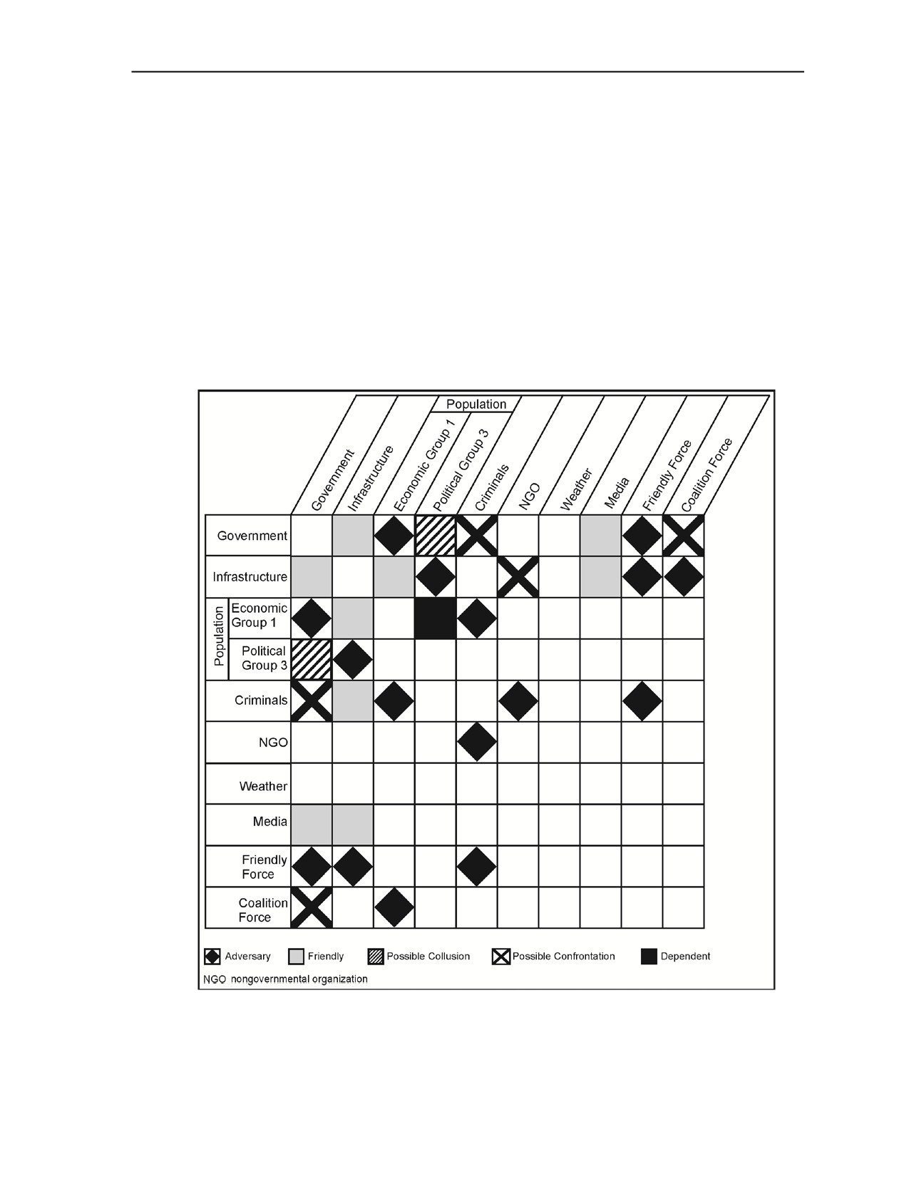
Urban Intelligence Tools and Products
infrastructure without contest from the owners or suppliers of the infrastructure. For example, this could be
considered the case when Slobodan Milosevic controlled the electricity supply for Kosovo. He apparently
used the infrastructure at his disposal to supply electricity to the population, but intermittently threatened to
deny the service in order to maintain control over a possibly hostile population. How can this information
be used by the commander and his staff? Perhaps by understanding the nature of two components of the
operational environment, the link between the two elements can either be eliminated or leveraged in order
to suit the needs of the friendly unit.
A-12. Using figure A-4, there is a relationship of possible collusion that exists between the government and
political group 3, and a friendly relationship between the government and the media. Some questions the
intelligence analyst might ask when reviewing this information include—
z
How can the government use the media to its advantage?
z
Will the government seek to discredit political group 3 using the media?
z
Will the population view the media’s reporting as credible?
z
Does the population see the government as willfully using the media to suit its own ends?
Figure A-4. Example relationship matrix
23 December 2015
TC 2-91.4
A-5

Appendix A
Activities Matrixes
A-13. Activities matrices help analysts connect individuals
(such as those in association matrices) to
organizations, events, entities, addresses, and activities—anything other than people. Information from this
matrix, combined with information from association matrices, assists analysts in linking personalities as
well. (See figure A-5.)
Figure A-5. Example activities matrix
Time Event Chart
A-14. Time event charts are chronological records of individual or group activities designed to store and
display large amounts of information in a small space. Analysts can use time event charts to help analyze,
for example, larger-scale patterns of activity and relationships. (See figure A-6.)
A-6
TC 2-91.4
23 December 2015

Urban Intelligence Tools and Products
Figure A-6. Example time event chart
LISTS AND TIMELINES OF KEY DATES
A-15. In many operations, including most stability operations, key local national holidays, historic events,
and significant cultural and political events can be extremely important. Soldiers are often provided with a
list of these key dates in order to identify potential dates of increased or unusual activity. These lists,
however, rarely include a description of why these dates are significant and what can be expected to happen
on the holiday. In some cases, days of the week themselves are significant. For example, in Bosnia
weddings were often held on Fridays and celebratory fire was a common occurrence on Friday afternoons
and late into the night. Timelines—a list of significant dates along with relevant information and analysis—
seek to provide a context to operational conditions. These timelines could include descriptions of
population movements or political shifts that are relevant to the operational area. They could also include a
brief historical record of the population or area, highlighting the activities of a certain population sector. As
analytic tools, timelines might help the intelligence analyst predict how key sectors of the population might
react to given circumstances.
23 December 2015
TC 2-91.4
A-7
Appendix A
CULTURE DESCRIPTION OR CULTURE COMPARISON CHART OR MATRIX
A-16. In order for the intelligence analyst to avoid the common mistake of assuming that only one
perspective exists, it may be helpful to clearly point out the differences between local ideology, politics,
predominant religion, acceptable standards of living, norms and mores, and U.S. norms. A culture
comparison chart can be a stand-alone tool, listing just the different characteristics of the culture in
question, or it can be comparative—assessing the host-nation population relative to known and familiar
conditions.
PERCEPTION ASSESSMENT MATRIX
A-17. Perception assessment matrices are often used by psychological operations personnel and can be a
valuable tool for intelligence analysts. Friendly force activities intended to be benign or benevolent might
have negative results if a population’s perceptions are not considered, then assessed or measured. This is
true because perceptions--more than reality--drive decision making and in turn could influence the
reactions of entire populations. The perception assessment matrix seeks to provide some measure of
effectiveness for the unit’s ability to reach an effect (for example, maintain legitimacy) during an operation.
In this sense, the matrix can also be used to directly measure the effectiveness of the unit’s civil affairs,
public affairs, and MISO efforts.
A-18. One proposed MISO campaign developed for Operation Restore Democracy in Haiti illustrates why
perception assessment is necessary. Prior to deployment, leaflets were published informing the Haitian
populace of U.S. intentions. The original leaflet was published in French, the language of the Haitian elite.
The one actually used for the MISO campaign was published in Creole, the official language of Haiti,
because an astute psychological operations team member realized the need to publish to the wider audience.
A-19. If the French flier had been dropped on Port-au-Prince, it could have undermined the American
mission to the country in several ways. The majority of the population would have been unable to read the
flier. The subsequent deployment of U.S. forces into the country, therefore, could have been perceived to be
hostile. The mission itself, which was intended in part to restore equity within the nation’s social structure,
could have backfired if the Haitians viewed the French flier as an indication of U.S. favoritism to the
Haitian elite.
A-20. Perception can work counter to operational objectives. Perceptions should therefore be assessed both
before and throughout an operation. Although it is not possible to read the minds of the local national
population, there are several means to measure its perceptions:
z
Demographic analysis and cultural intelligence are key components of perception analysis.
z
Understanding a population’s history can help predict expectations and reactions.
z
Human intelligence can provide information on population perceptions.
z
Reactions and key activities can be observed in order to decipher whether people act based on
real conditions or perceived conditions.
z
Editorial and opinion pieces of relevant newspapers can be monitored for changes in tone or
opinion shifts that can steer or may be reacting to the opinions of a population group.
A-21. Perception assessment matrices aim to measure the disparities between friendly force actions and
what population groups perceive. (See figure A-7 for a sample matrix.)
A-8
TC 2-91.4
23 December 2015

Urban Intelligence Tools and Products
Figure A-7. Perception assessment matrix
23 December 2015
TC 2-91.4
A-9
Appendix A
In addition to trying to assess the perceptions of each population group within an operational
area, it might serve the interests of the unit to assess its own perceptions of its activities. All
of the following questions can begin to be addressed by the unit’s scrutinizing its view of an
operation:
z
Are members of the unit exhibiting decidedly Western or American values that are not
appreciated by the host-nation population?
z
Are embedded American beliefs preventing the unit from understanding the host-nation
population or its multinational partners?
z
Is what the intelligence and command staff perceives really what is going on in the operational
area?
z
Does the population believe what the unit believes?
z
Is there something that is part of the population’s (or a subgroup’s) perception that can be
detrimental to the unit?
CIVIL AFFAIRS PRODUCTS
A-22. As mentioned previously in chapter 3, when deployed, civil affairs teams normally create an
assessment of the AO to which they are assigned. These assessments can provide intelligence personnel
with more detailed and more up-to-date information on the local situation. Civil affairs teams begin initial
assessments upon deployment to an AO and continuously update them throughout the duration of the
mission. While the information may initially be sparse, the categories of information that the civil affairs
teams are attempting to obtain clearly coincide with information that is of interest to intelligence staffs as
well.
(See FM 3-57 for doctrine on civil affairs area studies and assessments. See ATP 3-57.60 for
associated techniques and formats for civil affairs products.)
PRODUCTS
A-23. When conducting operations in the urban environment, many products may be required. These
products may be used individually or combined, as the mission requires. Many of the products listed in this
appendix will be created in conjunction with multiple staff elements.
POPULATION STATUS OVERLAYS
A-24. Population status overlays are a group of products rather than a single product. These products depict
how the population of a designated area is divided based on a single characteristic such as age, religion,
ethnicity, or income. For instance, one population status overlay can show what areas of a city are Catholic,
Protestant, Muslim, Hindu, and so on. Another overlay can indicate income levels or areas of known gang
membership. There is no limit to the number of overlays that can be created to depict the population
characteristics of a chosen area. The benefits of these overlays range from determining possible lines of
contention (that can exist between groups) or identification of the population or location in greatest need of
a certain activity or asset. (See figure A-8.)
A-25. Many examples of this type of overlay are produced by the United Nations Office for the
Coordination of Humanitarian Affairs and are readily available on its Web site (Relief Web). Population
status overlays and descriptions resulting from assessing the demographic characteristics of the host city
population might reveal significant differences between groups which can further enhance situational
understanding.
A-26. These overlays can be useful in identifying critical areas of the urban environment based on cultural
factors such as ethnic breakdown, tribal affiliation, or religious breakdown. One common method of
constructing these overlays is to color code sections of an urban area based on the majority identifications
of that area. This, however, can be misleading in some situations; an alternative method that more
accurately reflects the information that needs to be conveyed to the commander may be necessary. An
alternative method may entail dividing the urban area into sectors (as noted in chapter 3) using the same city
divisions used by local authorities (such as the local police precincts or municipal districts). Then insert pie
A-10
TC 2-91.4
23 December 2015

Urban Intelligence Tools and Products
charts for each sector showing each group and numbers or percentages. This technique can often help
clarify the situation as well as aiding in coordination efforts with the local authorities.
A-27. Population dispersal can vary significantly throughout the day. Another type of population status
overlay could indicate the location of population groups during the day, and how this changes over time.
This could assist in identifying possibly restrictive operating conditions or reveal times that are most
conducive for completion of a given mission.
Figure A-8. Population status overlay
CONGREGATION POINTS OR MASS ASSEMBLY POINTS OVERLAYS
A-28. Congregation or mass assembly points overlays depict the numbers, types, and locations of sites
where large numbers of people can be gathered for situations such as demonstrations, protection, feeding, in
the event of a disaster. These sites may be depicted on maps of an urban area. These sites include places of
religious worship, parks, schools, restaurants, squares, recreational centers, sports facilities, or
entertainment centers. If normally used for large gatherings of people, these locations can also be coded
with information on the population group that frequents them, days and hours of operation, and type of
activity that occurs.
URBAN TERRAIN OVERLAYS
A-29. Urban terrain overlays depict specific aspects of terrain unique to the urban environment. These
overlays can depict the details of a single building, a group of buildings, a section of an urban area, or even
an entire urban area. This type of overlay can also depict the different terrain zones apparent in an urban
area. Different types of terrain could be indicated using hatch marks or other indicators on a map or aerial
photograph. Zone types may be defined as close, orderly block, or dense random construction (as they are
in FM 3-06), or by any other designated characteristics required by the mission, such as zones of threat
occupation or zones divided by the types of predicted weapons effects.
23 December 2015
TC 2-91.4
A-11
Appendix A
A-30. A building type overlay can depict particular types of buildings, such as industrial buildings,
government buildings, military buildings, residential areas, businesses, warehouses or storage buildings,
religious centers, or media locations. Each of the buildings can be numbered or otherwise identified
depending on the needs of the commander and his staff. Additionally, entire sections of a city can be
marked depending on the construction type prevalent in a particular area. For instance, an area of dense
construction or a shantytown can be identified by appropriately labeling it on an overlay or directly onto an
aerial photograph.
A-31. Shantytowns may need to be specifically highlighted because they may be areas with notable food
shortages and where disease and pollution are most prevalent. Shantytowns may lack public utility
infrastructure
(for example, plumbing and electricity). Buildings are often made from miscellaneous
materials, and there is no consistent pattern of streets or corridors, complicating military operations. These
types of conditions result in a concentration of population that is generally dissatisfied and is a potential
source of unrest.
A-32. Unoccupied locations or buildings should also be identified. These locations or buildings can be used
as shelter for troops (friendly or threat) or as locations for friendly forces to demonstrate firepower if
necessary. The latter utility was demonstrated in Kosovo when a tank round was shot into an unoccupied
building in order to quell an increasingly worrisome civil disturbance. Additionally, unoccupied locations or
buildings could be logistics storage sites or meeting sites for threat forces.
A-33. An overlay depicting street widths in terms of major weapon systems can help identify which
formations or routes are most advisable for an area. A street wide enough to allow two Abrams tanks to
advance side by side enables the vehicles to better cover upper floors on opposite sides of the street, thereby
providing security for each other. Also, depicting buildings that exceed the depression or elevation
capabilities of vehicle weapons systems can identify areas of concern and potential enemy ambush
positions. Routes with such “dead spaces” may require convoys with additional or alternative weapons
systems able to eliminate this vulnerability.
A-34. Three urban terrain related products are used primarily in air operations: the roof coverage overlay,
the vertical and lateral references urban terrain feature overlay (also called UTFO), and the urban terrain
orientation graphic
(also called UTOG). (See ATP 3-06.1.) In urban terrain, roof coverage is more
meaningful to aviation operations than a ground-based horizontal visibility (fields of fire) analysis. The roof
coverage overlay depicts concealment from aerial observation and directly relates to the density of
structures. (See figure A-9.)
A-35. The vertical and lateral reference urban terrain feature overlay is used to prepare aircrews for aviation
urban operations. It annotates prominent navigation features as points (vertical structures), lines (lateral
references), or areas. The altitude in feet above mean sea level and, in parentheses, height above ground
level; for example, “1,460 feet (940 feet), follows vertical features. Elevation data, both mean sea level and
above ground level, are important for mission planning. This overlay may be combined with the urban
terrain orientation graphic detailed below. The urban terrain feature overlay identifies and plots—
z
Dominant vertical features.
z
Significant linear features.
z
Prominent, unique structures.
z
Currently known deliberate hazards or helicopter countermeasures.
A-12
TC 2-91.4
23 December 2015

Urban Intelligence Tools and Products
Figure A-9. Example roof cover overlay
A-36. The urban terrain orientation graphic overlay is used for aircrew orientation. A graphical depiction of
urban terrain characteristics allows a more thorough orientation than map reconnaissance alone. The urban
terrain orientation graphic is prepared by dividing the terrain into areas classified by density of structures
and building construction. Digital feature analysis data (also called DFAD) codes may be used on overlay
products to minimize clutter. This product serves as a substitute for the traditional combined obstacle
overlay for aviation operations and may be combined with the urban terrain feature overlay. (See figure A-
10 on page A-14.) The urban terrain orientation graphic provides the following urban area general
characteristics:
z
Density of structures.
z
Building construction.
z
Street pattern.
LINES OF COMMUNICATIONS OVERLAYS
A-37. LOC overlays identify the major LOCs within and around an urban area. This includes roads,
airfields, waterways, railroads, and foot paths. More advanced versions of these overlays can be combined
with the traffic conditions overlay and long-term surveillance of LOCs to determine what LOCs are most
heavily traveled at different times of the day. Threat forces can take advantage of higher volumes of civilian
traffic to use these LOCs for their own purposes.
A-38. These overlays can provide mobility information to assist planners and operators in determining what
equipment can move along the city’s mobility corridors. Pertinent data would include street widths, their
load capacity, sharp turns, potential ambush positions, potential sniper positions, and overhanging
obstacles.
A-39. Even though aerial surveillance can detect heavy traffic and traffic jams, it cannot predict when or
why they occur or whether or not they were part of the normal traffic pattern in the urban area. Creating an
LOC overlay that depicts normal traffic conditions can help the unit determine best times to operate. It can
also provide an indicator of an unusual event.
A-40. Waterways can play a significant role in the urban terrain. Among other things, they can be obstacles
or LOCs for illicit traffic (arms smuggling, drug smuggling, black marketeering). An overlay of local water
systems can list such important items as the width and depth of the waterway, key crossing sites (depending
on the size of the waterway), and key uses of that waterway (such as commerce, water source for crops,
drinking water source for the local population).
23 December 2015
TC 2-91.4
A-13
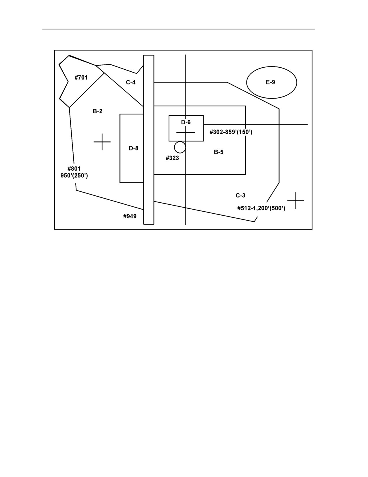
Appendix A
Figure A-10. Combined urban terrain orientation graphic/urban terrain feature overlay
(simplified example)
LINE OF SIGHT OVERLAYS
A-41. Perhaps even more important in the complex urban environment than in noncomplex terrain, line-of-
sight overlays can help define avenues of approach to an objective. Just as important are reverse line-of-
sight overlays that show the friendly avenues of approach from the enemy standpoint. The enemy can be
expected to try to cover dead space from the objective area with other positions or devices such as mines or
improvised explosive devices. However, if the enemy on the objective simply wants to flee, dead spaces
may only be covered by some type of early warning system.
A-42. Line-of-sight overlays can help pinpoint potential sniper positions along each relevant avenue of
approach based on the best possible locations given line of sight, elevation, exposure, and other pertinent
considerations. These positions are important because friendly forces can position personnel at these
locations to secure them or observe from them as readily as threat forces. (See ATP 2-01.3 for line-of-sight
overlay techniques.)
KEY INFRASTRUCTURE OVERLAYS
A-43. These overlays depict the locations of key infrastructure in an urban environment. Like population
status overlays, this type of overlay is a group of products rather than a single product. These overlays can
be produced by using a map, aerial photography, or graphic design that is appropriately marked with a
numbering or a color-coded system that indicates the type of asset as well as its specific attributes.
A-44. Key infrastructure required to sustain a city can be used as a tool of warfare both in the physical and
information domains. Securing key infrastructure from destruction will often be key to gaining and
maintaining a positive perception of friendly forces by the local populace. The most important part of the
key infrastructure is the critical infrastructure. This may include electricity generation plants, hydroelectric
A-14
TC 2-91.4
23 December 2015
Urban Intelligence Tools and Products
dams, pumping stations, water purification plants, sewage treatment plants, and anything that, if harmed,
can affect the living conditions of the population.
A-45. Key infrastructure overlays can be useful for identifying protected urban terrain. Protected terrain
encompasses areas that should not be destroyed, attacked, or occupied, or that have other use restrictions
based on international treaties, rules of engagement, and common sense—such as schools, hospitals, areas
with large amounts of phone and/or electrical wiring, and buildings with many stories. For example,
medical facilities may be depicted on their own key infrastructure overlay. Medical facilities are generally
no-fire areas for friendly forces and should be protected from damage or destruction so that they can
continue to take care of the local population once friendly forces have secured the urban area. Inadequate
health care for the local population can lead to both a negative perception of friendly forces and an
uncontrolled increase in disease which can affect friendly forces personnel working in the urban
environment directly.
A-46. Other types of key infrastructure overlays may depict media facilities, transportation facilities,
resource sites, culturally significant structures, dangerous facilities or subterranean infrastructure. Media
facilities include locations of transmission stations, antennas, newspaper production and distribution sites,
and television and radio stations. Transportation facilities include rail hubs, major bus connection sites,
subway lines, freeways, major thoroughfares, and intersections that are significant to the operation. A
resource sites key infrastructure overlay can depict locations where resources or supplies can be obtained,
such as building material locations, car lots, and appliance warehouses. This can include petroleum and
natural gas processing plants. Generally, these are the resources and infrastructure that are used to support
the critical resource needs of a population.
A-47. A key infrastructure overlay could highlight culturally significant structures such as places of
religious worship
(for example, churches, temples, mosques), all relevant government buildings and
internationally significant buildings (for example, embassies and consulates), and other structures or areas
of notable cultural importance. A key infrastructure overlay of dangerous facilities could depict structures
with known chemical, biological, or incendiary features. These are primarily toxic industrial material sites,
such as pharmaceutical plants, oil refineries, or fertilizer plants, but can include military-related areas like
ammunition storage sites. Finally, an overlay depicting key subterranean infrastructure can include
underground railways, sewer systems, electrical wiring, or any other underground feature of significance for
the operation.
URBAN MODELS
A-48. Operations within the urban environment follow standard Army doctrine regarding the wargaming
process. Because of the level of detail, however, there is a need for a modeling tool. These tools can range
from plastic or wooden models to overhead images to sand tables. Probably the best is the combination of
overhead imagery and three-dimensional models. Figure A-11 on page A-16 is an example of the imagery
and urban models. It reflects the Shugart-Gordon Urban training site at Fort Polk, Louisiana, and includes
an aerial imagery and a three-dimensional model with a multiple perspective view. These products should
be used together.
IMAGERY
A-49. Analysis of any urban environment would be incomplete without the use of imagery. Imagery
products for the urban environment include both aerial photography and satellite imagery. In many cases,
tasked aerial reconnaissance platforms, such as unmanned aircraft systems, respond directly to the
commander, thus ensuring timely and focused data collection. Because of technical limitations or priorities
established at the higher echelons, space-based and other national collection assets may not be available to
the commander and staff. Additionally, as each collection system has its own unique capabilities, traditional
black and white or infrared imagery may offer the best view of the target in a given situation.
23 December 2015
TC 2-91.4
A-15
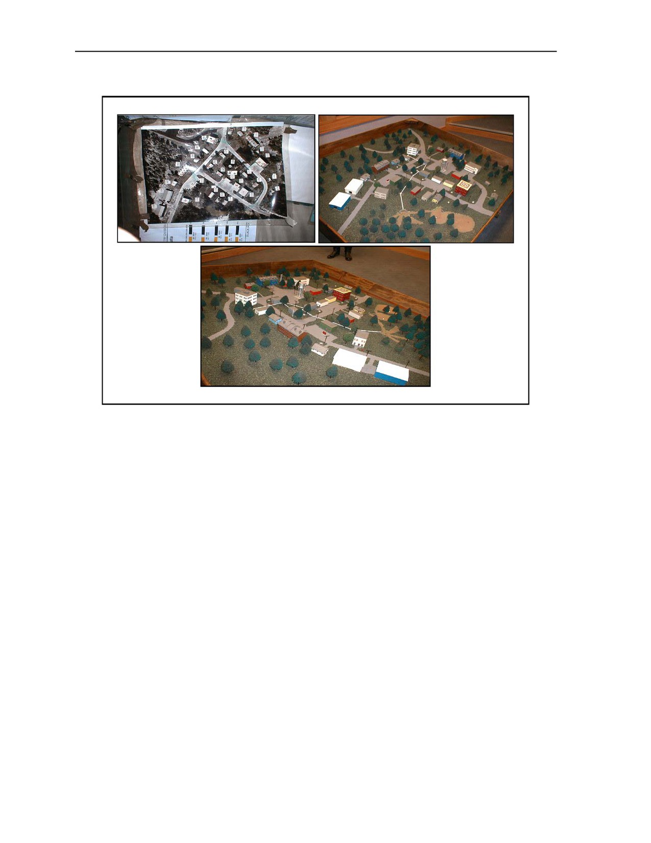
Appendix A
Figure A-11. Example of imagery and urban models
A-50. A key element in future urban operations may be the real-time imagery downlink capabilities of
space-based intelligence collection platforms. Employing state-of-the-art multispectral, infrared, electro-
optical imagery, and synthetic aperture radar (also called SAR) imaging, space-based systems can provide
important information in the urban environment. Data collected from such sources is transferred in digital
format, which then can be manipulated to address specific requirements. Intelligence staffs must be fully
aware of the capabilities and limitations of these systems as well as the procedures necessary to request this
support.
A-51. Advanced geospatial intelligence products are produced using any combination of imaging platforms:
visible, infrared, radar, or spectral depending on the requestor’s needs. Due to the versatility of these
products, they have a wide range of applications in the urban environment. Presenting imagery in an oblique
perspective by combining it with digital terrain elevation data provides a perspective view. Using spectral
imagery can accomplish discovery and identification of manmade and indigenous activity from patterns of
heat distribution and determination of changes in a scene imaged at various times. Other uses include
facility analysis, structural analysis, target detection, soil analysis, and damage assessment.
A-16
TC 2-91.4
23 December 2015
Source Notes
Paragraph
2-17
“In Vietnam, over two-thirds of Army hospital admissions were for disease. In 1968, disease
cost U.S. forces some 943,809 man days--roughly the equivalent of an infantry division for 2
months.” Spurgeon Neel, Medical Support of the U.S. Army-Vietnam 1965-1970, (U.S. Army
Historical Series), Washington, DC: U.S. Government Printing Office, 1972.
“Medical records of one Russian Brigade in Chechnya show that 15 percent of the brigade was
down with hepatitis at one time. Dirty water was the main culprit in the transmission of
hepatitis.” Lester W. Grau and William A. Jorgensen, “Viral Hepatitis and the Russian War in
Chechnya,” Army Medical Department Journal, May-June 1997, 2-4. Available online at the
Foreign Military Studies Office Web site: http://fmso.leavenworth.army.mil. Accessed
28 October 2015.
23 December 2015
TC 2-91.4
Source Notes-1
This page intentionally left blank.
Glossary
The glossary lists acronyms and terms with Army or joint definitions, and other
selected terms. Where Army and joint definitions are different, (Army) follows the
term. For multi-Service terms shared with the Marine Corps (Army/Marine Corps)
follows the term
SECTION I - ACRONYMS AND ABBREVIATIONS
ADP
Army doctrine publication
ADRP
Army doctrine reference publication
AO
area of operations
AR
Army regulation
ASCOPE
areas, structures, capabilities, organizations, people, and events
ATP
Army techniques publication
ATTP
Army tactics, techniques, and procedures
CALL
Center for Army Lessons Learned
CBRN
chemical, biological, radiological,and nuclear
DA
Department of the Army
FM
field manual
FMFRP
Fleet Marine Force reference publication
G-2
assistant chief of staff, intelligence
JP
joint publication
JWICS
Joint Worldwide Intelligence Communications System
LOC
line of communications
MCRP
Marine Corps reference publication
MCWP
Marine Corps warfighting publication
METT-TC
mission, enemy, terrain and weather, troops and support available, time
available, and civil considerations (mission variables) (Army)
MISO
military information support operations
NGA
National Geospatial-Intelligence Agency
NGO
nongovernmental organization
S-2
battalion or brigade intelligence staff officer
SIPRNET
SECRET Internet Protocol Router Network
TC
training circular
TTP
tactics, techniques, and procedures
U.S.
United States
23 December 2015
TC 2-91.4
Glossary-1
Glossary
SECTION II - TERMS
avenue of approach
(joint) An air or ground route of an attacking force of a given size leading to its objective or to key
terrain in its path. (JP 2-01.3)
combat information
(joint) Unevaluated data, gathered by or provided directly to the tactical commander which, due to its
highly perishable nature or the criticality of the situation, cannot be processed into tactical intelligence
in time to satisfy the user’s tactical intelligence requirements. (JP 2-01)
enemy
A party identified as hostile against which the use of force is authorized. (ADRP 3-0)
intelligence
(joint) 1. The product resulting from the collection, processing, integration, evaluation, analysis, and
interpretation of available information concerning foreign nations, hostile or potentially hostile forces
or elements, or areas of actual or potential operations. 2. The activities that result in the product.
3. The organizations engaged in such activities. (JP 2-0)
intelligence preparation of the battlefield
(Army) The systematic process of analyzing the mission variables of enemy, terrain, weather, and civil
considerations in an area of interest to determine their effect on operations. (ATP 2-01.3/ MCRP 2-3A)
intelligence requirement
(joint) 1. Any subject, general or specific, upon which there is a need for the collection of information,
or the production of intelligence. 2. A requirement for intelligence to fill a gap in the command’s
knowledge or understanding of the operational environment or threat forces. (JP 2-0)
intelligence warfighting function
The related tasks and systems that facilitate understanding of the enemy, terrain, and civil
considerations. (ADRP 3-0)
key terrain
(joint) Any locality, or area, the seizure or retention of which affords a marked advantage to either
combatant. (JP 2-01.3)
liaison
(joint) That contact or intercommunication maintained between elements of military forces or other
agencies to ensure mutual understanding and unity of purpose and action. (JP 3-08)
line of communications
(joint) A route, either land, water, and/or air, that connects an operating military force with a base of
operations and along which supplies and military forces move. (JP 2-01.3)
line of sight
(Army/Marine Corps) The unobstructed path from a Soldier’s/Marine’s weapon, weapon sight,
electronic sending and receiving antennas, or piece of reconnaissance equipment from one point to
another. (ATP 2-01.3/MCRP-2-3A)
mobility corridor
(joint) Areas that are relatively free of obstacles where a force will be canalized due to terrain
restrictions allowing military forces to capitalize on the principles of mass and speed (JP 2-01.3).
Glossary-2
TC 2-91.4
23 December 2015
References
REQUIRED PUBLICATIONS
These documents must be available to the intended users of this publication.
Most joint publications are available online: www.dtic.mil/doctrine/new_pubs/jointpub.htm.
Most Army doctrinal publications are available online: www.apd.army.mil.
ADRP 1-02. Terms and Military Symbols. 2 February 2015.
ATP 3-06.1. Aviation Urban Operations: Multi-Service Tactics, Techniques, and Procedures for
Aviation Urban Operations. 19 April 2013.
ATTP 3-06.11. Combined Arms Operations in Urban Terrain. 10 June 2011.
FM 3-06. Urban Operations. 26 October 2006.
JP 1-02. Department of Defense Dictionary of Military and Associated Terms. 8 November 2010.
RELATED PUBLICATIONS
These documents are cited in this publication.
JOINT AND DEPARTMENT OF DEFENSE PUBLICATIONS
Most joint publications are available online: www.dtic.mil/doctrine/new_pubs/jointpub.htm.
JP 2-0. Joint Intelligence. 22 October 2013.
JP 2-01. Joint and National Support to Military Operations. 5 January 2012.
JP 2-01.3. Joint Intelligence Preparation of the Operational Environment. 21 May 2014.
JP 3-06. Joint Urban Operations. 20 November 2013.
JP 3-08. Interorganizational Coordination During Joint Operations. 24 June 2011.
JP 3-13. Information Operations. 27 November 2012.
JP 3-13.2. Military Information Support Operations. 21 November 2014.
JP 3-57. Civil-Military Operations. 11 September 2013.
ARMY PUBLICATIONS
Most Army doctrinal publications are available online: www.apd.army.mil.
ADRP 2-0. Intelligence. 31 August 2012.
ADRP 3-0. Unified Land Operations. 16 May 2012.
ADRP 5-0. The Operations Process. 17 May 2012.
ATP 2-01. Plan Requirements and Assess Collection. 19 August 2014.
ATP 2-01.3/MCRP 2-3A. Intelligence Preparation of the Battlefield/Battlespace. 10 November 2014.
ATP 2-19.4. Brigade Combat Team Intelligence Techniques. 10 February 2015.
ATP 2-33.4. Intelligence Analysis. 18 August 2014.
ATP 2-91.7. Intelligence Support to Defense Support to Civil Authorities. 29 June 2015.
ATP 3-36. Electronic Warfare Techniques. 16 December 2014.
ATP 3-53.2. Military Information in Conventional Operations. 7 August 2015.
ATP 3-57.50. Civil Affairs Civil Information Management. 6 September 2013.
23 December 2015
TC 2-91.4
References-1
References
ATP 3-57.60. Civil Affairs Planning. 27 April 2014.
ATP 3-90.37. Countering Improvised Explosive Devices. 29 July 2014.
FM 2-0. Intelligence Operations. 15 April 2014.
FM 3-07. Stability. 2 June 2014.
FM 3-13. Inform and Influence Activities. 25 January 2013.
FM 3-24/MCWP 3-33.5. Insurgencies and Countering Insurgencies. 13 May 2014.
FM 3-55. Information Collection. 3 May 2013.
FM 3-57 (FM 3-05.40). Civil Affairs Operations. 31 October 2011.
FM 3-90-1. Offense and Defense Volume 1. 22 March 2013.
FM 3-97.6. Mountain Operations. 28 November 2000.
FM 6-0. Commander and Staff Organization and Operations. 5 May 2014.
FM 27-10. The Law of Land Warfare. 18 July 1956.
OTHER PUBLICATIONS
Medical Support of the U.S. Army-Vietnam 1965-1970. U.S. Army Historical Series. Spurgeon Neel.
Washington, DC: U.S. Government Printing Office. 1972.
NSG: Geospatial-Intelligence (GEOINT) Basic Doctrine Publication 1-0. National Geospatial
Intelligence Agency. September 2006. Available online at https://www.us.army.mil. Log in to
Army Knowledge Online. Then navigate to the following folder: Files> Organizations> DOD
Organizations>Army>Headquarters, Department of the Army>Chief of Staff of the
Army>Intelligence>FOUO MI Doctrine>Related references. Accessed 23 October 2015.
“Viral Hepatitis and the Russian War in Chechnya.” Lester W. Grau and William A. Jorgensen. Army
Medical Department Journal, May-June 1997, 2-4. Available online at the Foreign Military
Studies Office Web site: http://fmso.leavenworth.army.mil. Accessed 28 October 2015.
WEB SITES
Army Geospatial Center. http://www.tec.army.mil. Accessed. 23 October 2015.
GEOnet Names Server. http://geonames.nga.mil/gns/html/index.html. Accessed 2 November 2015.
Intelligence Knowledge Network. https://www.ikn.army.mil/.
Accessed 29 October 2015.
National Center for Medical Intelligence. https://www.ncmi.detrick.army.mil.
Accessed 27 October 2015.
National Geospatial-Intelligence Agency (NIPRNET). https://www.nga.mil/.
Accessed 27 October 2015.
National Geospatial-Intelligence Agency (SIPRNET). https://globe.NGA.smil.mil.
Accessed 27 October 2015.
National Geospatial-Intelligence Agency (JWICS). globe.nga.ic.gov. Accessed 28 October 2015.
United Nations Office for the Coordination of Humanitarian Affairs. http://www.reliefweb.int.
Accessed 23 October 2015.
RECOMMENDED READINGS
These sources contain relevant supplemental information.
JOINT PUBLICATIONS
Most joint publications are available online: www.dtic.mil/doctrine/new_pubs/jointpub.htm.
JP 3-13.3. Operations Security. 4 January 2012.
References-2
TC 2-91.4
23 December 2015