Military reference books and manuals (2009-2023, Volume 8) - page 27
FOR OFFICIAL USE ONLY
Appendix A
Table A-1. Example civil affairs assessment (continued)
1. Identified emergency centers (gyms, schools, etc).
2. Hospital surge capabilities.
3. Medical staff requirements (doctors, nurses, etc).
4. Communications systems.
D. Disaster relief.
1. Disaster relief materials and assets available.
a. Supplies and foodstuffs.
b. Materials.
c. Medicine (medical supplies).
d. Heavy equipment (construction).
e. Contractors (transportation, water storage, power generation).
f. Transportation assets (air, ground, water).
g. Mobile power generation (generators and size).
h. Labor.
i. Emergency shelters.
j. Water treatment and storage.
k. Mobile medical units and/or hospitals.
2. Emergency transportation network analysis.
a. Assumptions.
b. Roads, railways, airports, etc., that have sustained damage in previous disasters.
E. In-country POCs by position and telephone number.
1. US POCs (Embassy, US Agency for International Development, Defense Attaché Office
personnel).
2. HN POCs (with telephone numbers).
PRODUCTS
A-24. When conducting operations in the urban environment, many products may be required. These
products may be used individually or combined, as the mission requires. Many of the products listed in this
appendix will be created in conjunction with multiple staff elements.
POPULATION STATUS OVERLAYS
A-25. Population status overlays are a group of products rather than a single product. These products depict
how the population of a designated area is divided based on a single characteristic such as age, religion,
ethnicity, or income. For instance, one population status overlay can show what areas of a city are Catholic,
Protestant, Muslim, Hindu, and so on. Another overlay can indicate income levels or areas of known gang
membership. There is no limit to the number of overlays that can be created to depict the population
characteristics of a chosen area. The benefits of these overlays range from determining possible lines of
contention (that can exist between groups) or identification of the population or location in greatest need of
a certain activity or asset. (See Figure A-8.)
A-30
FM 2-91.4
January 2008 (Draft)
FOR OFFICIAL USE ONLY

FOR OFFICIAL USE ONLY
Urban Intelligence Tools and Products
Figure A-8. Population status overlay
A-26. Many examples of this type of overlay are produced by the United Nations Office for the
Coordination of Humanitarian Affairs and are readily available on its web site at http://www.reliefweb.int.
Population status overlays and descriptions resulting from assessing the demographic characteristics of the
host city population might reveal significant differences between groups which can further enhance
situational understanding.
A-27. These overlays can be useful in identifying critical areas of the urban environment based on cultural
factors such as ethnic breakdown, tribal affiliation, or religious breakdown. One common method of
constructing these overlays is to color code sections of an urban area based on the majority identifications
of that area. This, however, can be misleading in some situations; an alternative method that more
accurately reflects the information that needs to be conveyed to the commander may be necessary. An
alternative method may entail dividing the urban area into sectors (as noted in Chapter 3) using the same
city divisions that local authorities such as the local police precincts or municipal districts can often help
clarify the situation as well as aid in coordination efforts with the local authorities and then inserting pie
charts for each sector showing each group and numbers and/or percentages.
January 2008 (Draft)
FM 2-91.4
A-31
FOR OFFICIAL USE ONLY
FOR OFFICIAL USE ONLY
Appendix A
A-28. Population dispersal can vary significantly throughout the day. Another type of population status
overlay could indicate the location of population groups during the day, and how this changes over time.
This could assist in identifying possibly restrictive operating conditions or reveal times that are most
conducive for completion of a given mission.
CONGREGATION POINTS OR MASS ASSEMBLY POINTS OVERLAYS
A-29. Congregation or mass assembly points overlays depict the numbers, types, and locations of sites
where large numbers of people can be gathered for situations such as demonstrations, protection, feeding,
in the event of a disaster. These sites may be depicted on maps of an urban area. These sites include places
of religious worship, parks, schools, restaurants, squares, recreational centers, sports facilities, or
entertainment centers. If normally used for large gatherings of people, these locations can also be coded
with information on the population group that frequents them, days and hours of operation, and type of
activity that occurs.
URBAN TERRAIN OVERLAYS
A-30. Urban terrain overlays depict specific aspects of terrain unique to the urban environment. These
overlays can depict the details of a single building, a group of buildings, a section of an urban area, or even
an entire urban area. This type of overlay can also depict the different terrain zones apparent in an urban
area. Different types of terrain could be indicated using hatch marks or other indicators on a map or aerial
photograph. Zone types may be defined as close, orderly block, or dense random construction (as they are
in FM 3-06), or by any other designated characteristics required by the mission, such as zones of threat
occupation or zones divided by the types of predicted weapons effects.
A-31. A building type overlay can depict particular types of buildings, such as industrial buildings,
government buildings, military buildings, residential areas, businesses, warehouses or storage buildings,
religious centers, or media locations. Each of the buildings can be numbered or otherwise identified
depending on the needs of the commander and his staff. Additionally, entire sections of a city can be
marked depending on the construction type prevalent in a particular area. For instance, an area of dense
construction or a shantytown can be identified by appropriately labeling it on an overlay or directly onto an
aerial photograph.
A-32. Shantytowns may need to be specifically highlighted because they may be areas with notable food
shortages and where disease and pollution are most prevalent. Shantytowns may lack public utility
infrastructure
(for example, plumbing and electricity). Buildings are often made from miscellaneous
materials, and there is no consistent pattern of streets or corridors, complicating military operations. These
types of conditions result in a concentration of population that is generally dissatisfied and is a potential
source of unrest.
A-33. Unoccupied locations or buildings should also be identified. These locations or buildings can be
used as shelter for troops (friendly or threat) or as locations for friendly forces to demonstrate firepower if
necessary. The latter utility was demonstrated in Kosovo when a tank round was shot into an unoccupied
building in order to quell an increasingly worrisome civil disturbance. Additionally, unoccupied locations
or buildings could be logistics storage sites or meeting sites for threat forces.
A-34. An overlay depicting street widths in terms of major weapon systems can help identify which
formations or routes are most advisable for an area. A street wide enough to allow two Abrams tanks to
advance side by side enables the vehicles to better cover upper floors on opposite sides of the street,
thereby providing security for each other. Also, depicting buildings that exceed the depression or elevation
capabilities of vehicle weapons systems can identify areas of concern and potential enemy ambush
positions. Routes with such “dead spaces” may require convoys with additional or alternative weapons
systems able to eliminate this vulnerability.
A-32
FM 2-91.4
January 2008 (Draft)
FOR OFFICIAL USE ONLY

FOR OFFICIAL USE ONLY
Urban Intelligence Tools and Products
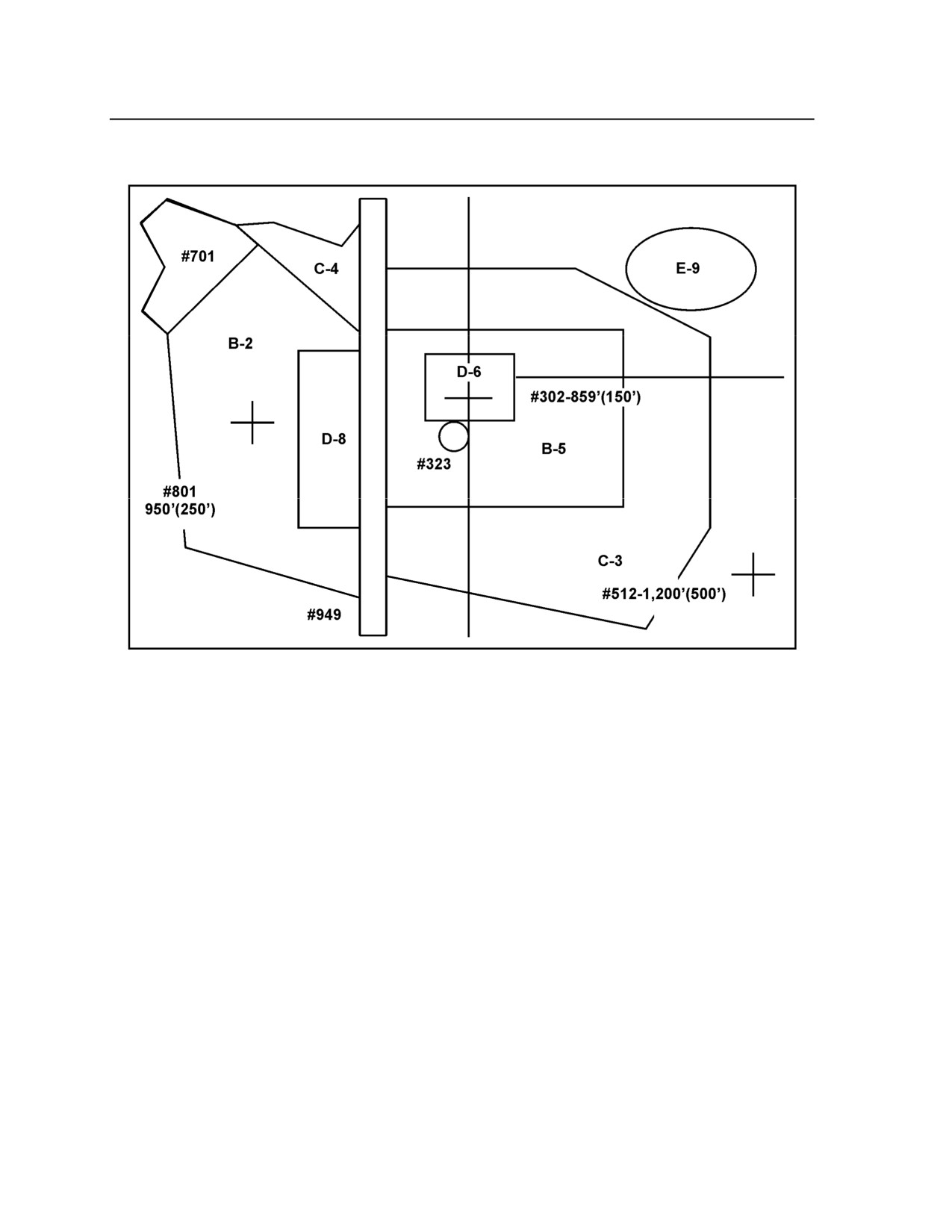
A-35. Three urban terrain related products that are used primarily in air operations are the roof coverage
overlay, the vertical and lateral references urban terrain feature overlay (UTFO), and the urban terrain
orientation graphic (UTOG). (See FM 3-06.1.) In urban terrain, roof coverage is more meaningful to
aviation operations than a ground-based horizontal visibility (fields of fire) analysis. The roof coverage
overlay depicts concealment from aerial observation and directly relates to the density of structures. (See
Figure A-9.)
A-36. The vertical and lateral reference UTFO is used to prepare aircrews for aviation urban operations. It
annotates prominent navigation features as points (vertical structures), lines (lateral references), or areas.
The altitude in feet above mean sea level (MSL) and, in parentheses, height above ground level (AGL); for
example, “1,460 feet (940 feet), follows vertical features. Elevation data, both MSL and AGL, are
important for mission planning. This overlay may be combined with the UTOG detailed below. The UTFO
identifies and plots:
z
Dominant vertical features.
z
Significant linear features.
z
Prominent, unique structures.
z
Currently known deliberate hazards or helicopter countermeasures.
Figure A-9. Example roof cover overlay
A-37. The UTOG overlay is used for aircrew orientation. A graphical depiction of urban terrain
characteristics allows a more thorough orientation than map reconnaissance alone. The UTOG is prepared
by dividing the terrain into areas classified by density of structures and building construction. Digital
Feature Analysis Data (DFAD) codes may be used on overlay products to minimize clutter. This product
serves as a substitute for the traditional combined obstacle overlay for aviation operations and may be
combined with the UTFO. (See Figure A-10.) The UTOG provides the following urban area general
characteristics:
z
Density of structures.
z
Building construction.
January 2008 (Draft)
FM 2-91.4
A-33
FOR OFFICIAL USE ONLY
FOR OFFICIAL USE ONLY
Appendix A
z
Street pattern.
Figure A-10. Combined UTOG/UTFO (simplified example)
LINES OF COMMUNICATION OVERLAYS
A-38. LOC overlays identify the major LOCs within and around an urban area. This includes roads,
airfields, waterways, railroads, and foot paths. More advanced versions of these overlays can be combined
with the traffic conditions overlay and long-term surveillance of LOCs to determine what LOCs are most
heavily traveled at different times of the day. Threat forces can take advantage of higher volumes of
civilian traffic to use these LOCs for their own purposes.
A-39. These overlays can provide mobility information to assist planners and operators in determining
what equipment can move along the city’s mobility corridors. Pertinent data would include street widths,
their load capacity, sharp turns, potential ambush positions, potential sniper positions, and overhanging
obstacles.
A-40. Even though aerial surveillance can detect heavy traffic and traffic jams, it cannot predict when or
why they occur or whether or not they were part of the normal traffic pattern in the urban area. Creating an
LOC overlay that depicts normal traffic conditions can help the unit determine best times to operate. It can
also provide an indicator of an unusual event.
A-41. Waterways can play a significant role in the urban terrain. Among other things, they can be obstacles
or LOCs for illicit traffic (arms smuggling, drug smuggling, black marketeering). An overlay of local water
systems can list such important items as the width and depth of the waterway, key crossing sites
A-34
FM 2-91.4
January 2008 (Draft)
FOR OFFICIAL USE ONLY
FOR OFFICIAL USE ONLY
Urban Intelligence Tools and Products
(depending on the size of the waterway), and key uses of that waterway (such as commerce, water source
for crops, drinking water source for the local population).
LINE OF SIGHT OVERLAYS
A-42. Perhaps even more important in the complex urban environment than in non-complex terrain, line-
of-sight overlays can help define AAs to an objective. Just as important are reverse line-of-sight overlays
that show the friendly AAs from the enemy standpoint. We can expect the enemy to try to cover dead
space from the objective area with other positions or devices such as mines or IEDs. If the enemy on the
objective simply wants to flee, dead spaces may simply be covered by some type of early warning system.
A-43. Line-of-sight overlays can help pinpoint potential sniper positions along each relevant AA based on
the best possible locations given line of sight, elevation, exposure, and other pertinent considerations.
These positions are important because friendly forces can position personnel at these locations to secure
them or observe from them as readily as threat forces.
KEY INFRASTRUCTURE OVERLAYS
A-44. These overlays depict the locations of key infrastructure in an urban environment. Like population
status overlays, this type of overlay is a group of products rather than a single product. These overlays can
be produced by using a map, aerial photography, or graphic design that is appropriately marked with a
numbering or a color-coded system that indicates the type of asset as well as its specific attributes.
A-45. Key infrastructure required to sustain a city can be used as a tool of warfare both in the physical and
information domains. Securing key infrastructure from destruction will often be key to gaining and
maintaining a positive perception of friendly forces by the local populace. The most important part of the
key infrastructure is the critical infrastructure. This may include electricity generation plants, hydroelectric
dams, pumping stations, water purification plants, sewage treatment plants, and anything that, if harmed,
can affect the living conditions of the population.
A-46. Key infrastructure overlays can be useful for identifying protected urban terrain. Protected terrain
encompasses areas that should not be destroyed, attacked, or occupied, or that have other use restrictions
based on international treaties, ROE, and common sense—such as schools, hospitals, areas with large
amounts of phone and/or electrical wiring, and buildings with many stories. For example, medical facilities
may be depicted on their own key infrastructure overlay. Medical facilities are generally NFAs for friendly
forces and should be protected from damage or destruction so that they can continue to take care of the
local population once friendly forces have secured the urban area. Inadequate health care for the local
population can lead to both a negative perception of friendly forces and an uncontrolled increase in disease
which can affect friendly forces personnel working in the urban environment directly.
A-47. Other types of key infrastructure overlays may depict media facilities, transportation facilities,
resource sites, culturally significant structures, dangerous facilities or subterranean infrastructure. Media
facilities include locations of transmission stations, antennas, newspaper production and distribution sites,
and television and radio stations. Transportation facilities include rail hubs, major bus connection sites,
subway lines, freeways, major thoroughfares, and intersections that are significant to the operation. A
resource sites key infrastructure overlay can depict locations where resources or supplies can be obtained,
such as building material locations, car lots, and appliance warehouses. This can include petroleum and
natural gas processing plants. Generally, these are the resources and infrastructure that are used to support
the critical resource needs of a population.
A-48. A key infrastructure overlay could highlight culturally significant structures such as places of
religious worship
(for example, churches, temples, mosques), all relevant government buildings and
internationally significant buildings (for example, embassies and consulates), and other structures or areas
of notable cultural importance. A key infrastructure overlay of dangerous facilities could depict structures
with known chemical, biological, or incendiary features. These are primarily TIM sites, such as
January 2008 (Draft)
FM 2-91.4
A-35
FOR OFFICIAL USE ONLY

FOR OFFICIAL USE ONLY
Appendix A
pharmaceutical plants, oil refineries, or fertilizer plants, but can include military-related areas like
ammunition storage sites. Finally, an overlay depicting key subterranean infrastructure can include
underground railways, sewer systems, electrical wiring, or any other underground feature of significance
for the operation.
URBAN MODELS
A-49. Operations within the urban environment follow standard Army doctrine regarding the wargaming
process. Because of the level of detail, however, there is a need for a modeling tool. These tools can range
from plastic or wooden models to overhead images to sand tables. Probably the best is the combination of
overhead imagery and 3D models. Figure A-11 is an example of the imagery and urban models. It reflects
the Shugart-Gordon Urban training site at Fort Polk, LA, and includes an aerial imagery and a 3D Model
with a multiple perspective view. These products should be used together.
IMAGERY
A-50. Analysis of any urban environment would be incomplete without the use of imagery. Imagery
products for the urban environment include both aerial photography and satellite imagery. In many cases,
tasked aerial reconnaissance platforms, such as UASs, respond directly to the commander, thus ensuring
timely and focused data collection. Because of technical limitations or priorities established at the higher
echelons, space-based and other national collection assets may not be available to the commander and staff.
Additionally, as each collection system has its own unique capabilities, traditional black and white or
infrared imagery may offer the best view of the target in a given situation.
Figure A-11. Example of imagery and urban models
A-36
FM 2-91.4
January 2008 (Draft)
FOR OFFICIAL USE ONLY
FOR OFFICIAL USE ONLY
Urban Intelligence Tools and Products
A-51. A key element in future urban operations may be the real-time imagery downlink capabilities of
space-based intelligence collection platforms. Employing state-of-the-art multispectral, infrared, EO
imagery, and synthetic aperture radar
(SAR) imaging, space-based systems can provide important
information in the urban environment. Data collected from such sources is transferred in digital format,
which then can be manipulated to address specific requirements. Intelligence staffs must be fully aware of
the capabilities and limitations of these systems as well as the procedures necessary to request this support.
A-52. Advanced geospatial intelligence products are produced using any combination of imaging
platforms: visible, infrared, radar, or spectral depending on the requestor’s needs. Due to the versatility of
these products, they have a wide range of applications in the urban environment. Presenting imagery in an
oblique perspective by combining it with digital terrain elevation data provides a perspective view. Using
spectral imagery can accomplish discovery and identification of manmade and indigenous activity from
patterns of heat distribution and determination of changes in a scene imaged at various times. Other uses
include facility analysis, structural analysis, target detection, soil analysis, and damage assessment.
January 2008 (Draft)
FM 2-91.4
A-37
FOR OFFICIAL USE ONLY
FOR OFFICIAL USE ONLY
Appendix B
Non-US Small Arms and Light Weapons Effects in the
Urban Environment
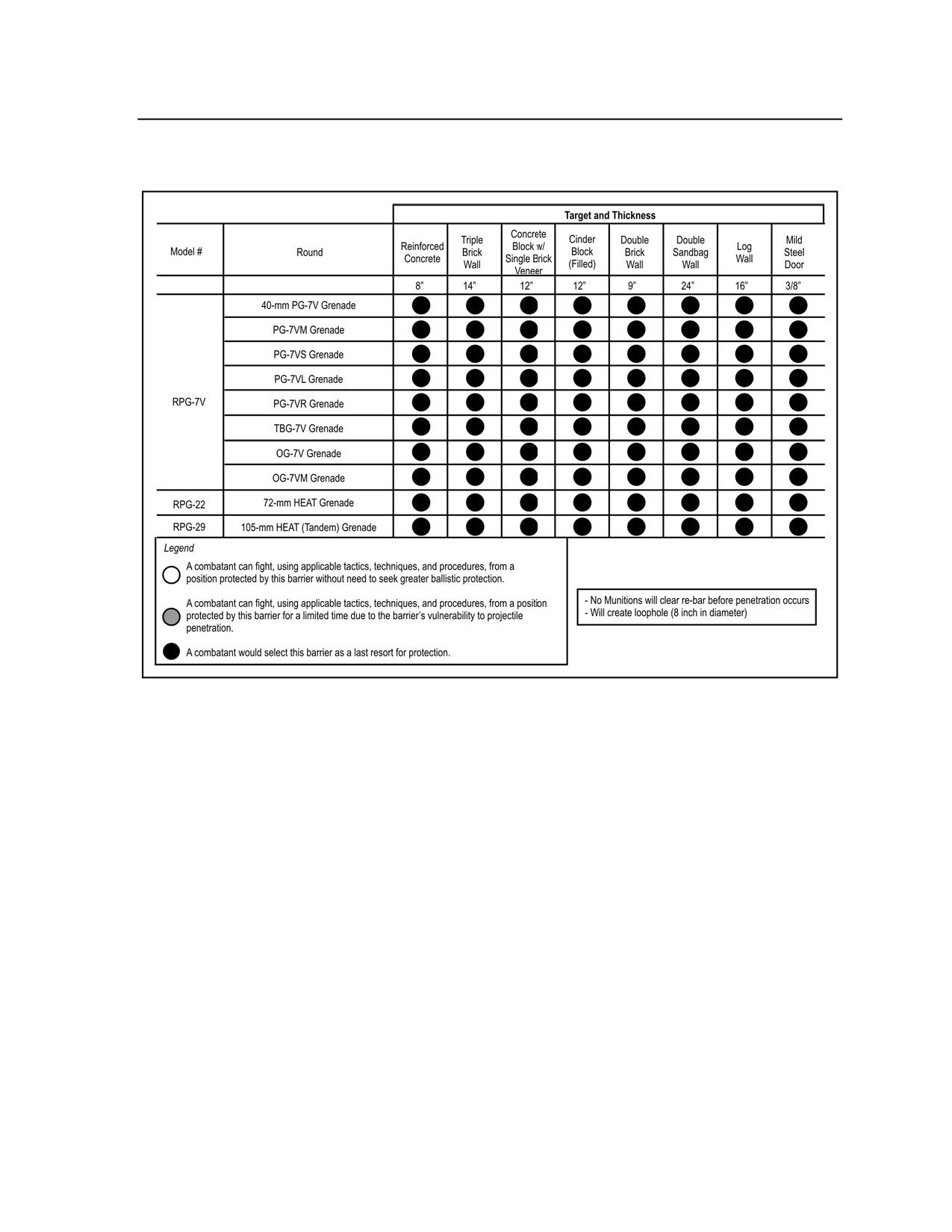
B-1. The US Army Materiel Systems Analysis Activity provided the data in this appendix to use as a
reference for planning and training. The charts were compiled to assess a variety of threat (non-US)
weapons against many structures or materials found in an urban environment. This assessment was based
on a review of limited test data, comparisons to US weapons data against urban structures and materials,
subject matter expertise, and professional military judgment.
B-2. There are seven tables. The acronym list and Note at the end of this appendix pertain to these tables.
January 2008 (Draft)
FM 2-91.4
B-1
FOR OFFICIAL USE ONLY

FOR OFFICIAL USE ONLY
Appendix B _______________________________________________________________________________
Table B-1. Rifles, machine, and submachine guns
B-2
FM 2-91.4
January 2008 (Draft)
FOR OFFICIAL USE ONLY

FOR OFFICIAL USE ONLY
Non-US Small Arms and Light Weapons Effects in the Urban Environment
Table B-2. Grenade launchers
January 2008 (Draft)
FM 2-91.4
B-3
FOR OFFICIAL USE ONLY

FOR OFFICIAL USE ONLY
Appendix B _______________________________________________________________________________
Table B-3. Antitank guided missiles
B-4
FM 2-91.4
January 2008 (Draft)
FOR OFFICIAL USE ONLY
FOR OFFICIAL USE ONLY
Non-US Small Arms and Light Weapons Effects in the Urban Environment
Table B-4. Antitank grenade launchers (RPGs)
January 2008 (Draft)
FM 2-91.4
B-5
FOR OFFICIAL USE ONLY

FOR OFFICIAL USE ONLY
Appendix B _______________________________________________________________________________
Table B-5. Artillery
B-6
FM 2-91.4
January 2008 (Draft)
FOR OFFICIAL USE ONLY

FOR OFFICIAL USE ONLY
Non-US Small Arms and Light Weapons Effects in the Urban Environment
Table B-6. Antiaircraft
January 2008 (Draft)
FM 2-91.4
B-7
FOR OFFICIAL USE ONLY

FOR OFFICIAL USE ONLY
Appendix B _______________________________________________________________________________
Table B-7. Weapons systems on helicopters
B-8
FM 2-91.4
January 2008 (Draft)
FOR OFFICIAL USE ONLY
FOR OFFICIAL USE ONLY
Non-US Small Arms and Light Weapons Effects in the Urban Environment
Table B-8. Acronyms used in the tables
AP
Armor Piercing
APE
Armor Piercing Explosive
APFSDS-T
Armor Piercing, Fin Stabilized, Discarding Sabot-Tracer
API
Armor Piercing Incendiary
API-T
Armor Piercing Incendiary-Tracer
ATGM
Anti Tank Guided Missile
AT-HE
Anti Tank-High Explosive
CC
Cargo Carrier
CMU
Concrete Modular Unit
Duplex T
Duplex Tracer
FRAG
Fragmentation
FRAG-HE
Fragmentation-High Explosive
HE
High Explosive
HEFI
High Explosive Fragmentation Incendiary
HEI
High Explosive Incendiary
HEI-T
High Explosive Incendiary-Tracer
HEAT
High Explosive Anti Tank
HEAT-FS
High Explosive Anti Tank-Fin Stabilized
HVAP-T
Hypervelocity Armor Piercing-Tracer
Incendiary-T
Incendiary-Tracer
RA
Reactive Armor
RPG
Rocket Propelled Grenade
TP
Target Practice
Note. The CMU used in the worst case scenario is a cinderblock filled with concrete and
reinforced with one-half inch rebar placed at 8- to 10-inch intervals. The limited test data that is
available is primarily focused on perpendicular engagements. Engagements at reasonable
oblique angles (less than 45 degrees) would have the biggest impact on small arms, probably
some limited impact on medium caliber AP rounds and no impact on large caliber rounds,
missiles, or RPGs.
January 2008 (Draft)
FM 2-91.4
B-9
FOR OFFICIAL USE ONLY
FOR OFFICIAL USE ONLY
Glossary
The glossary lists acronyms and terms with Army or joint definitions, and other selected terms. Where Army
and joint definitions are different, (Army) follows the term. Terms for which FM 2-0 is the proponent
FM (authority) are marked with an asterisk (*) and followed by the number of the paragraph (¶) where they are
discussed. For other terms, the number of the proponent FM follows the definition. JP 1-02 and FM 1-02 are
posted in the Joint Electronic Library, which is available online and on CD-ROM.
SECTION I - ACRONYMS AND ABBREVIATIONS
3D
three dimensional
AA
avenue of approach
AC
Active Component
ACE
Analysis Control Element
ACT
Analysis Control Team
ADA
air defense artillery
AFMIC
Armed Forces Medical Intelligence Center
AGL
above ground level
AIDS
acquired immune deficiency syndrome
AKO
Army Knowledge Online
AMD
air and missile defense
AO
area of operation
AOI
area of interest
ASCOPE
areas, structures, capabilities, organization, people, and events
BDE
brigade
BN
battalion
C2
command and control
CAT
category
CBRN
chemical, biological, radiological, nuclear
CED
captured enemy document
CI
counterintelligence
CICA
Counterintelligence Coordinating Authority
CNA
computer network attack
CNO
computer network operations
COA
course of action
COG
center of gravity
C-SIGINT
counter-signals intelligence
CSP
contingency support package
CSS
contingency support study
DA-IIS
Department of the Army Intelligence Information Service
DF
direction finding
DFAD
Digital Feature Analysis Data
January 2008 (Draft)
FM 2-91.4
Glossary-1
FOR OFFICIAL USE ONLY
FOR OFFICIAL USE ONLY
Glossary
DHA
detainee holding area
DIA
Defense Intelligence Agency
DMZ
demilitarized zone
DNA
Deoxyribonucleic Acid
DOD
Department of Defense
DOCEX
document exploitation
DTED
digital terrain evaluation data
DTG
date-time group
EEI
Essential Elements of Information
EM
electromagnetic
EO
electro-optical
EOD
explosive ordnance disposal
EPW
enemy prisoner of war
etc
and so forth
EW
electronic warfare
FID
Foreign Internal Defense
FLIR
forward-looking infrared
FM
frequency modulation
FP
force protection
GEOINT
geospatial intelligence
GPS
global positioning system
GRG
gridded reference graphic
HAT
HUMINT Analysis Team
HCT
human intelligence collection team
HOC
HUMINT Operations Cell
HIV
human immunodeficiency virus
HLZ
helicopter landing zone
HN
host nation
HUMINT
human intelligence
ICL
intelligence coordination line
IDF
Israel Defense Force
IED
improvised explosive device
IMINT
imagery intelligence
INTELINK
intelligence link
IO
information operations
IPB
intelligence preparation of the battlefield
ISR
intelligence, surveillance, and reconnaissance
JTF
joint task force
JSTARS
Joint Surveillance Target Attack Radar System
Glossary-2
FM 2-91.4
January 2008 (Draft)
FOR OFFICIAL USE ONLY
FOR OFFICIAL USE ONLY
Glossary
JWICS
Joint Worldwide Intelligence Communications System
LANDSAT
land satellite
LOB
line of bearing
LOC
line of communication
LZ
landing zone
MANPADS
Manportable Air Defense Systems
MASINT
measurement and signature intelligence
MDMP
military decision-making process
METT-TC
mission, enemy, terrain and weather, troops and support available, time
available, and civil considerations
MGRS
Military Grid Reference System
MI
Military Intelligence
MSL
mean sea level
NA
not applicable
NAI
named area of interest
NATO
North Atlantic Treaty Organization
NFA
no-fire area
NGA
National Geospatial-Intelligence Agency
NGIC
National Ground Intelligence Center
NGO
nongovernmental organization
NISH
NEO intelligence support handbook
NVD
night vision device
OAKOC
observation and fields of fire, avenues of approach, key terrain, obstacles,
cover and concealment
OSC
Open Source Center
OSINT
open source intelligence
PEO
peace enforcement operation
PEWD
platoon early warning device
PIR
priority intelligence requirement
POL
petroleum, oils, and lubricants
PLO
Palestine Liberation Organization
plt
platoon
PSYOP
psychological operations
PZ
pickup zone
RFI
request for information
RPG
rocket-propelled grenade
SALUTE
size, activity, location, unit, time, equipment (spot report)
SAM
surface-to-air missile
SAR
synthetic aperture radar
January 2008 (Draft)
FM 2-91.4
Glossary-3
FOR OFFICIAL USE ONLY
FOR OFFICIAL USE ONLY
Glossary
SBU
sensitive but unclassified
SIGINT
signals intelligence
SIPRNET
Secret Internet Protocol Router Network
SJA
staff judge advocate
SOCCE
Special Operations Command and Control Element
SOCRATES
Special Operations Command Research, Analysis, and Threat Evaluation
System
SOF
special operations forces
SOP
standing operating procedure
SOR
special orders and requests
SPA
Special PSYOP Assessment
SPS
Special PSYOP Study
ST
special text
SWO
staff weather officer
TAI
target area of interest
TEC
Topographic Engineering Center
TECHINT
technical intelligence
TIM
toxic industrial material
TS
Top Secret
TTP
tactics, techniques, and procedures
UAS
unmanned aircraft system
UHF
ultra high frequency
US
United States
USAIC
US Army Intelligence Center
USAR
US Army Reserve
USSOCOM
US Special Operations Command
UTAMS
unattended transient acoustic measurement and signature intelligence sensor
UTFO
urban terrain feature overlay
UTM
universal transverse mercator
UTOG
urban terrain orientation graphic
UTP
Urban Tactical Planner
WGS
World Geodetic System
WIT
weapons intelligence team
WMD
weapons of mass destruction
WSS
Weapon Surveillance System
WTI
weapons technical intelligence
Glossary-4
FM 2-91.4
January 2008 (Draft)
FOR OFFICIAL USE ONLY
FOR OFFICIAL USE ONLY
Glossary
SECTION II - TERMS
avenue of approach
(joint) An air ground route of an attacking force of a given size leading to its objective or to key terrain
in its path.term. (JP 1-02)
combat information
(joint) Unevaluated data gathered or provided to the tactical commander which, due to its highly
perishable nature or the criticality of the situation, cannot be processed into tactical intelligence in time
to satisfy the user's tactical intelligence requirements.(JP 1-02)
detainee
(Army) An individual who is captured by or placed in the custody of a duly constituted governmental
organization for a period of time.(FM 34-52)
dislocated civilian
(Army) A generic term that describes a civilian who has been forced to move by war, revolution, or
natural or man-made disaster from his or her home to some other location. Dislocated citizens include
displaced persons, refugees, evacuees, stateless persons, and war victims. Legal and political
considerations define the subcategories of a dislocated civilian. (FM 3-07)
displaced person
(joint) A civilian who is involuntarily outside the national boundaries of his or her country.[Note:
Army adds: “or as an internally displaced person is a civilian involuntarily outside his area or region
within his country.” (JP 1-02)
enemy
The individual, group of individuals (organized or not organized), paramilitary or military force,
national entity, or national alliance that is in opposition to the United States, its allies, or multinational
partners.
enemy prisoner of war (Army) (EPW)
(Army) An individual or group of individuals detained by friendly forces in any OPERATIONAL
ENVIRONMENT who meet the criteria as listed in Article 4 of the Geneva Convention Relative to the
Handling of Prisoners of War. (FM 1-02)
infrastructure
(joint) All building and permanent installations necessary for support, redeployment, and military
forces operations (e.g., barracks, headquarters, airfields, communications facilities, stores, port
installations, and maintenance stations). (JP 4-01.8)
intelligence
(joint) 1. The product resulting from the collection, processing, integration, analysis, evaluation, and
interpretation of available information concerning foreign countries or areas. 2. Information and
knowledge about an adversary obtained through observation, investigation, analysis, or understanding.
(JP 2-0)
intelligence preparation of the battlefield
The systematic, continuous process of analyzing the threat and environment in a specific geographic
area. Intelligence preparation of the battlefield is designed to support the staff estimate and military
decision-making process. Most intelligence requirements are generated as a result of the IPB process
and its interrelation with the decision making process. (FM 34-130)
January 2008 (Draft)
FM 2-91.4
Glossary-5
FOR OFFICIAL USE ONLY
FOR OFFICIAL USE ONLY
Glossary
intelligence process
(joint) The process by which information is converted into intelligence and made available to users.
The process consists of six interrelated intelligence operations: planning and direction, collection,
processing and exploitation, analysis and production, dissemination and integration, and evaluation
and feedback. (JP 2-01)
intelligence requirement
(joint) 1. Any subject, general or specific, upon which there is a need for collection of information or
the production of intelligence. 2. A requirement for intelligence to fill a gap in the commander’s
knowledge or understanding of the operational environment or threat forces. (JP 2-0).
intelligence warfighting function
The related tasks and systems that facilitate understanding of the enemy, terrain, weather, and civil
considerations. (FMI 5-0.1)
J-2X
The joint directorate responsible for controlling, coordinating, and deconflicting all human
intelligence and counterintelligence collection activities and keeping the joint force J-2 informed on
all human intelligence and counterintelligence activities conducted in the joint force area of
responsibility. (FM 2-0)
key terrain
(joint) Any locality or area, the seizure or retention of which, affords a marked advantage to either
combatant. (JP 1-02)
liaison
(joint) That contact or intercommunication maintained between elements of military forces or other
agencies to ensure mutual understanding and unity of purpose and action. (JP 3-08)
lines of communication
(joint) A route, either land, water, and/or air, that connects an operating military force with a base of
operations and along which supplies and military forces move. (JP 1-02)
line of sight
The unobstructed path from a soldier, weapon, weapon site, electronic sending and receiving antennas,
or piece of reconnaissance equipment to another point. (FM 34-130).
mobility corridor
(joint) Areas where a force will be canalized due to terrain restrictions. They allow military forces to
capitalize on the principles of mass and speed and are therefore relatively free of obstacles. (JP 2-
01.3).
named area of interest
(joint) The geographical area where information that will satisfy a specific information requirement
can be collected. named areas of interest are usually selected to capture indications of adversary
courses of action, but also may be related to conditions of the operational environment. (JP 2-01.3)
noncombatant
1. An individual, in an area of combat operations, who is not armed and is not participating in any
activity in support of any of the factions or forces involved in combat. 2. An individual, such as
chaplain or medical personnel, whose duties do not involve combat. (FM 3-07)
order of battle
(joint) The identification strength, command structure, and disposition of the personnel, units, and
equipment of any military force. (JP 2-01.3)
Glossary-6
FM 2-91.4
January 2008 (Draft)
FOR OFFICIAL USE ONLY
FOR OFFICIAL USE ONLY
Glossary
priority intelligence requirement
(joint) An intelligence requirement stated as a priority for intelligence support, that the commander
and staff need to understand the adversary or operational enviornment. (JP 5-0)
processing (intelligence)
(joint) A system of operations designed to convert raw data into useful information. (JP 1-02)
production (intelligence)
Conversion of information into intelligence through the integration, analysis, evaluation, and
interpretation of all-source data and the preparation of intelligence products in support of known or
anticipated user requirements. (FM 2-0)
relevant information
All information of importance to commanders and staffs in the exercise of command and control.
(FM 3-0)
request for information
(joint) Any specific, time-sensitive ad hoc requirement for intelligence information or products to
support an ongoing crisis or operation not necessarily related to standing requirements or scheduled
intelligence production. A request for information can be initiated to respond to operational
requirements and will be validated in accordance with the theater command’s procedures. (JP 2-01)
Tactical Questioning
(Army) The questioning of the local population (noncombatants and enemy prisoners of
war/detainees) for information of immediate tactical value.
terrain analysis
(joint) The collection, analysis, evaluation, and interpretation of geographic information on the natural
and manmade features of the terrain, combined with other relevant factors, to predict the effect of the
terrain on military operations. (JP 1-02)
Traffic Control Post
(Army) Manned post used to preclude interruption of traffic flow or movement along designated
routes. They are used to support maneuver and mobility support operations only when needed. (FM 3-
19.4)
January 2008 (Draft)
FM 2-91.4
Glossary-7
FOR OFFICIAL USE ONLY
FOR OFFICIAL USE ONLY
References
The bibliography lists field manuals by new number followed by old number.
DOCUMENTS NEEDED
These documents must be available to the intended users of this publication.
AR 525-13, Antiterrorism, 4 January 2002
FM 1-02 (101-5-1)/MCRP 5-12A, Operational Terms and Graphic, 21 September 2004
FM 2-22.3, Human Intelligence Collector Operations, 1 March 2006
FM 2-91.6, Soldier Surveillance and Reconnaissance: Fundamentals of Tactical Information
Collection, December 2007
FM 3-06, Urban Operation, 26 October 2006
FM 3-06.1, Aviation Urban Operations-Multiservice Procedures for Aviation Urban Operations,
9 July 2005
FM 3-06.11 (90-10-1), Combined Arms Operations in Urban Terrain, 28 February 2002
FM 7-98, Operations in a Low Intensity Conflict, 19 October 1992
FM 27-10, Law of Land Warfare, July 1956
ST 2-91.2, Intelligence Support to the Installation Commander’s Antiterrorism (AT) and Force
Projection (FP) Programs, February 2004
DD Form 2745, Enemy Prisoner of War Capture Tag, May 1996
READINGS RECOMMENDED
These sources contain relevant supplemental information.
National Geospatial - Intelligence Agency, Geospatial Intelligence (GEOINT) Basic Doctrine,
GEOINT Publication 1, June 2004
JOINT PUBLICATIONS
Most joint publications are available online: http://www.dtic.mil/doctrine/jel/
JP 2-0, Doctrine for Intelligence Support to Joint Operations, 9 March 2000
JP 3-06, Doctrine for Joint Urban Operations, 16 September 2002
JP 3-07, Joint Doctrine for Military Operations Other Than War, 16 June 1995
JP 3-53, Doctrine for Joint Psychological Operations, 10 July 1996
JP 3-54, Joint Doctrine for Operations Security, 24 January 1997
JP 3-57, Joint Doctrine for Civil-Military Operations, 8 February 2001
JP 3-57.1, Joint Doctrine for Civil Affairs, 14 April 2003
Joint Task Force Commander’s Handbook for Peace Operations, 16 June 1997
Handbook for Joint Urban Operations, 17 May 2000
MARINE CORPS PUBLICATIONS
Most Marine Corps doctrinal publications are available online: https://www.doctrine.quantico.usmc.mil/
MCWP 2-1, Intelligence Operations, February 1998
MCWP 2-12, MAGTF Intelligence Production and Analysis, 27 September 2001
MCWP 3-35.3, Military Operations on Urbanized Terrain (MOUT), 16 April 1998
NAVMC 2890, Small Wars (Reprint of 1940 US Marine Corps Small Wars Manual), 1 April 1987
Urban Generic Information Requirements Handbook (UGIRH), 2000
January 2008 (Draft)
FM 2-91.4
References-1
References
ARMY PUBLICATIONS
Most Army doctrinal publications are available online: http://155.217.58.58/atdls.htm
Most of the Center for Army Lessons Learned (CALL) products are available online: http://call.army.mil/
The Foreign Military Studies Office publications area available online:
AR 195-5, Criminal Investigation Evidence Procedures, 28 August 1982
AR 381-10, US Army Intelligence Activities, 1 July 1984
FM 33-1-1, Psychological Operations Techniques and Procedures, 1994
FM 2-0 (34-1), Intelligence, May 2004
FM 2-01.3 (34-130), Intelligence Preparation of the Battlefield, 8 July 1994 [Revision to be published
in 2005]
FM 3-07 (100-20), Stability Operations and Support Operations, 20 February 2003
FM 6-0, Mission Command: Command and Control of Army Forces, 11 August 2003
FM 7-15, Army Universal Task List (AUTL), 31 August 2003
FM 7-92, The Infantry Reconnaissance Platoon and Squad (Airborne, Air Assault, Light Infantry),
23 December 1992. Change 1, 13 December 2001
FM 34-3, Intelligence Analysis, 15 March 1990
FM 34-54, Technical Intelligence, 30 January 1998
FM 41-10, Civil Affairs Operations, 11 January 1993
FMI 2-22.9, Open Source Intelligence, December 2006
ST 2-22.3 (FM 34-52), Human Intelligence Collection, 28 September 1992 [Revision to be published
in August 2004]
ST 2-22.7, Tactical Human Intelligence and Counterintelligence Operations, April 2002
ST 2-91.1 (FM 34-7), Intelligence Operations in Stability Operations and Support Operations,
4 November 2004
TC 2-22.602, Signals Intelligence Tactics, Techniques, and Procedures
TC 25-20, A Leader’s Guide to After-Action Reviews, 30 September 1993
Interpreter OPS, Multi-Service Reference Manual for Interpreter Operations, February 2004 (Copies
can be obtained by email: alsa.director@langley.af.mil)
CALL Newsletter 99-16, Urban Combat Operations TTP, November 1999
CALL Newsletter 03-4, Small Unit Leader’s Guide to Urban Operations, May 2003
CALL Newsletter 03-20, Stability Operations and Support Operations (SOSO), July 2003
How They Fight: Armies of the World, National Ground Intelligence Center Publication
NGIC-1122-0062-01, MOUT-Worldwide, Volume 4-01, August 2001
Medical Support in a Counter-Guerrilla War: Epidemiological Lessons Learned in the Soviet-Afghan
War, Lester W. Grau, FMSO, and MAJ William A. Jorgensen, U.S. Army, 1995. This article
was previously published in U.S. Army Medical Department Journal, May-June 1995
The Battle of Grozny: Deadly Classroom for Urban Combat, Timothy L. Thomas, FMSO. This article
was previously published in Parameters, Summer 1999
The Caucasus Conflict and Russian Security: The Russian Armed Forces Confront Chechnya, Part 1:
Section 1. Timothy L. Thomas, FMSO, 1995. This article was previously published in Journal
of Slavic Military Studies, June 1995
The Caucasus Conflict and Russian Security: The Russian Armed Forces Confront Chechnya, Part 1:
Section 2. Timothy L. Thomas, FMSO, 1995. This article was previously published in Journal
of Slavic Military Studies, June 1995
The Caucasus Conflict and Russian Security: The Russian Armed Forces Confront Chechnya III. The
Battle for Grozny, 1-26 January 1995, Timothy L. Thomas, FMSO, 1995. This article was
previously published in Journal of Slavic Military Studies, March 1997.
References-2
FM 2-91.4
January 2008 (Draft)
FOR OFFICIAL USE ONLY
Glossary
Changing Russian Urban Tactics: The Aftermath of the Battle for Grozny. Lester W. Grau, FMSO,
July 1995. This article was previously published in INSS Strategic Forum, July 1995.
Air Operations in Low Intensity Conflict: The Case of Chechnya, Timothy L. Thomas, Foreign
Military Studies Office, Fort Leavenworth, KS. This article was previously published in
Airpower Journal Winter 1997.
A 'Crushing' Victory: Fuel-Air Explosives and Grozny 2000. Lester W. Grau and Timothy Smith,
Illustrated by John Richards and Ivan Pavlov, Foreign Military Studies Office, Fort
Leavenworth, KS. This article was previously published in Marine Corps Gazette August
2000.
Geopolitics and Urban Armed Conflict in Latin America, Geoffrey Demarest, FMSO, 1995. This
article was previously published in Small Wars and Insurgencies, Spring 1995.
Grozny 2000: Urban Combat Lessons Learned. Timothy L. Thomas, Foreign Military Studies Office,
Fort Leavenworth, KS. This article was previously published in Military Review, July-August
2000.
Viral Hepatitis and the Russian War in Chechnya. Lester W. Grau , FMSO and William A. Jorgensen,
DO MC USAR, 1997, (CALL Publication #98-23). This article was previously published in
U.S. Army Medical Department Journal, May-June 1997.
Mars and Hippocrates in Megapolis: Urban Combat and Medical Support, Leavenworth, KS and
CDR Charles J. Gbur Jr., MC, USNR, March 2003. This article was previously published in
U.S. Army Medical Department Journal January-March 2003.
MOUT in Iraq: Population Dependent? Mr. Timothy L. Thomas, Foreign Military Studies Office, Fort
Leavenworth, KS
Night Stalkers and Mean Streets: Afghan Urban Guerrillas, Ali A. Jalali and Lester W. Grau, Foreign
Military Studies Office, Fort Leavenworth, KS. This article was previously published in
Infantry January-April 1999.
Combat in Cities: The LA Riots and Operation R, William W. Mendel, FMSO, 1996
Russian Lessons Learned From the Battles For Grozn,. Timothy L. Thomas and Mr. Lester W. Grau,
FMSO. This article was previously published in Marine Corps Gazette, April 2000.
Russian-Manufactured Armored Vehicle Vulnerability in Urban Combat: The Chechnya Experience,
Lester W. Grau, FMSO. This article was previously published in Red Thrust Star, January
1997
A Face of Future Battle: Chechen Fighter Shamil Basayev, MAJ Raymond C. Finch, III, FMSO, 1997.
This article was previously published in Military Review, June-July 1997.
“Soft Log” and Concrete Canyons: Russian Urban Combat Logistics in Grozny, Lester W. Grau and
Mr. Timothy L. Thomas, Foreign Military Studies Office, Fort Leavenworth, KS. This article
was previously published in Marine Corps Gazette, October 1999.
Bashing The Laser Range Finder With a Rock, Lester W. Grau, FMSO, 1997. This article was first
published in Military Review, May-June 1997.
Urban Warfare Communications: A Contemporary Russian View, Lester W. Grau, FMSO. This article
was previously published in Red Thrust Star, July 1996.
Urban Combat: Confronting the Specter, Lester W. Grau and Dr. Jacob W. Kipp, Foreign Military
Studies Office, Fort Leavenworth, KS. This article was previously published in Military
Review, July-August 1999.
A Weapon For All Seasons: The Old But Effective RPG-7 Promises to Haunt the Battlefields of
Tomorrow, Lester W. Grau, FMSO. This article was previously published in Infantry,
May-August 1998.
Why the Russian Military Failed in Chechnya, MAJ Raymond C. Finch, III, U. S. Army, FMSO,
(CALL Publication #98-16)
January 2008 (Draft)
FM 2-91.4
References-3
References
Future War: Non-Lethal Weapons in Twenty-First Century Warfare, New York: St. Martin’s Press,
1999
DEPARTMENT OF DEFENSE PUBLICATIONS
DOD Directives available online: http://web7.whs.osd.mil/corres.htm
DOD O-2000.12-H, DOD Antiterrorism Handbook, 9 February 2004.
PUBLIC LAW AND OTHER PUBLICATIONS
The United States Code is available online: http://uscode.house.gov/usc.htm
Most RAND studies are available online: http://www.rand.org/publications/
Die Hard Buildings: Control Architecture - a Challenge for the Urban Warrior, Military Review,
September-October 2003
The Savage Wars of Peace: Soldiers’ Voices 1945-1989, London: Michael Joseph, 1990
Street Smart: Intelligence Preparation of the Battlefield for Urban Operations, Russell W. Glenn and
Jamison Joe Medby, RAND Document Nr. MR-1287-A, 2002
Aerospace Operations in Urban Environments: Exploring New Concepts, Alan Vick, John Stillion, et
al. RAND Document Nr. MR-1187-AF, 2000
Heavy Matter: Urban Operations' Density of Challenges, Russell W. Glenn, RAND Document
Nr. MR-1239-JS/A, 2000
Marching under Darkening Skies: The American Military and the Impending Urban Operations
Threat, Russell W. Glenn, RAND Document Nr. MR-1007-A, 1998
Mars Unmasked: The Changing Face of Urban Operations. Sean J.A. Edwards, RAND Document
Nr. MR-1173-A, 2000
Russian Snipers In the Mountains and Cities of Chechnya, Lester W. Grau and Charles Q. Cutshaw,
Infantry magazine, Summer 2002
The Art of Darkness: Deception and Urban Operations. Scott Gerwehr and Russell W. Glenn, RAND
Document Nr. MR-1132-A, 2000
The City's Many Faces: Proceedings of the RAND Arroyo-MCWL-J8 UWG Urban Operations
Conference, Russell W. Glenn, RAND Document Nr. CF-148-A, 2000
Detainee Treatment Act of 2005
References-4
FM 2-91.4
January 2008 (Draft)
FOR OFFICIAL USE ONLY
Index
Entries are by paragraph number unless stated otherwise.
A
Armed Forces Medical
Buildings
Intelligence Center
Activities Matrix, A-13,
Analysis of, 1-27, 1-29,
(AFMIC), 3-13, 3-14
Table 5-1
Figure A-5
ASCOPE, 1-3, 1-4, Figure 1-1
Example information
Air Operations, 1-55, 3-19,
Association Matrix
requirements for,
A-35
Table 1-4
as software tool, A-4
Airspace
Types of, 1-9, 1-23, 1-25,
Example, Figure A-3
in urban operations, 1-27,
1-31, 1-43, 1-49, 1-89,
1-28, 1-31
Purpose, A-8
4-12, A-31 through
used by Military Police,
Air Defense Artillery (ADA),
A-34, A-48, Tables 1-4,
3-29
3-21
1-16, 5-1
Avenues of Approach (AA),
Air Level. See multidimensional
1-38
battlefield.
C
Air or ground route, 1-38
Analysis, 1-27, 1-29, 1-34, A-8
CBRN, 1-20
Biological, Table A-1
Friendly, 1-34, A-42
Effects, 3-19
Counterintelligence (CI),
in airspace, 1-28, 1-31
Hazards, 3-19
4-30
in line of sight overlays,
A-43
Types of weapons,
Demographic, A-20,
Tables 2-1 and 2-2
Table A-4
in mobility corridors, 1-27
Civil Affairs, 3-23
DFAD codes, A-37
in multidimensional
battlefield, 1-27, 1-37
Assessment, 3-23, A-17,
Geospatial, 4-8, 4-9, A-50,
A-23, Table A-1
A-52
in urban terrain, 1-15
Example, Table A-1
in Civil Affairs, Table A-1
MASINT monitoring of,
4-27
Team, 3-24, A-23,
Link, 2-6, A-4, A-6
Table A-1
Relevant, A-43
Network, Table A-1
Civilians
Aviation, 3-19
Nodal, 3-37
Collecting information,
Assets, 1-31
OSC, 4-44
2-10
Hazards, 2-24
Pattern, 1-49, 2-6, A-4,
Dislocated, Table A-1
Operations, 2-24, A-35,
A-5, Figure A-1
Hazards in aviation, 2-24
A-36, A-37
Plot sheet, Figure A-1
in urban environment,
Units, 2-24, 3-19
Structural, 1-30, 1-32,
1-60, 1-73
1-52, 2-25, A-52
CNA. See Computer Network
B
Terrain and society, 1-21,
Attack.
1-91, 3-41, 3-38
Balkans
Combat
Terrain and weather, 1-5,
US operations in Bosnia,
Assessments, 1-41, 2-14
1-55
1-76, 1-77, A-15
Definition, Glossary-5
Tools, 4-2, A-4, A-6
US operations in Kosovo,
Urban, 1-44, 1-55, 2-5,
1-76, 1-77, A-11, A-33
Urban, 4-2, 4-8, 4-36,
Table 2-1
5-18, A-50
Bosnia. See Balkans.
Combined obstacle overlay,
Analyst Notebook, A-4
Boundaries, 1-14, 1-18, 1-88,
A-37
1-106, 3-54, 4-6, Tables 1-5
Anti-tank Guided Missiles
Communications. See
and A-1
(ATGM), Table B-3
Infrastructure.
January 2008 (Draft)
FM 2-91.4
Index-1
Index
Computer Network Attack
Digital Topographic Support
in criminal organizations,
(CNA), 2-13, Table 2-5
System, A-4
2-9
Contingency Support Study
Document Exploitation
Threat in urban
(CSS), 3-38. See also
(DOCEX), 4-4
environment, 2-1,
Defense Intelligence
Table 2-2
Agency.
E
Counterintelligence (CI)
H
Electronic Warfare
Functions, 4-28, 4-29
Handbooks
Enemy, 2-14
Technical services, 4-31
for Medical Facilities, 3-13
In information operations,
Screening, 4-28, 4-29
2-11, Table 2-5
noncombatant evacuation
Crime
operations Intelligence
Tactical jamming, 2-14
Support, 3-43
in urban populations,
Energy. See also
Table 1-5
Health Issues. See Medical.
Infrastructure.
Organizations, 2-10,
Human Intelligence (HUMINT),
in weapon systems,
Tables 2-4 and A-1
4-3 through 4-7, 5-20
Table B-7
Crimelnk, A-4
Assets, 4-1, 4-6
Engagement area
Cultural Comparison Chart,
Collectors, 4-3, 4-4, 4-7
Definition, 1-39, 1-40
A-16
in stability operations and
in mobility corridors, 1-37
Culture
civil support operations,
in multidimensional
5-20
and social structure, 1-57,
battlefield, 1-26, 1-27,
1-62, 1-71, Table A-1
Intelligence discipline, 4-3
1-37
in urban environment,
in urban environment, 4-3,
Engineers, 3-9
1-14, 1-57, 1-60, 3-7,
4-5, A-20
City, 1-55
4-7, 5-3, A-16
Operational Management
Combat, 1-52, 1-53
Team, B-36
Comparison chart or
in CI, 4-28, 4-29
matrix, A-16
Screening, 4-4
National and Local, 1-96
Responsibilities, 1-27
D
I
Explosive Ordnance Disposal
Debriefing
Imagery Intelligence (IMINT),
(EOD)
1-38, 1-44, 4-23, A-50,
conducted by collectors, 4-4
in ISR planning, 3-32
Figure A-11, Table 1-4
format, 5-24
Analysis, 4-9
military personnel, 5-24,
F
and geospatial
5-25
Fire Hazards. 2-25
intelligence, 4-8, A-52
techniques, 3-2
Food Distribution. See
Briefs, 3-41
transportation personnel,
Infrastructure.
CSP, 3-38
3-33
Forward Looking Infrared
EO, A-51
Defense Intelligence Agency
Radar, 3-22
GRG, 3-40
(DIA)
in deception operations,
Contingency Support
G
Tables 1-6 and 2-5
Package, 3-38
Geospatial
LANDSAT, 3-38
Contingency Support
Information, 4-8, 4-50,
Overhead, 3-43, 4-11,
Study, 3-38
4-51
4-13, 4-14, A-49
Gridded Reference
Products, 3-10, A-52
Products, 3-41, 4-18, 5-9,
Graphics, 3-40
Gridded Reference Graphic
A-50
Intelligence Support
(GRG), 3-40. See also
SAR, A-51
Package, 3-37
Defense Intelligence Agency
Systems, 4-9
Denial and Deception. See
(DIA).
Information Operations (IO)
UAS, 4-12
Guerrillas. See also insurgents.
Index-2
FM 2-91.4
January 2008 (Draft)
FOR OFFICIAL USE ONLY
FOR OFFICIAL USE ONLY
____________________________________________________________________________________ Index
Urban models, A-51,
SIGINT effects, 4-19, 4-30
Support package, 3-37
Figure A-11
Transportation, 1-93, 1-94,
Intelligence collection. See
Indicators
A-47, Tables 1-6, 2-1,
Intelligence.
5-1, and A-1
Potential, 4-16
Intelligence products. See
Facilities, A-47
Intelligence.
Specific, 4-22
in cities, 1-12, 1-90,
Information Operations (IO)
1-91
K
as a threat, 2-11
in low visibility, 1-52, 1-55
Key infrastructure overlay,
Considerations, Table 2-5
in urban functional zones,
A-44
Denial and Deception,
1-23
Kosovo. See Balkans.
2-11 through 2-15,
Network, 1-93
Table 2-5
Information requirements,
Personnel, 3-33
L
Table 2-5
Public, 1-86, Table A-1
Law enforcement and fire
in satellite patterns, 1-18,
Systems, 1-14
fighting. See Infrastructure.
1-20
Water and waste, 1-101,
Line of communication
OAKOC factors, Table 1-6
(LOC), 1-41, 1-71,
Insurgents. See guerillas.
A-38, A-40, Table 1-13
Infrastructure, 1-88, 3-17, 3-47,
in criminal organizations,
3-50, 3-53, 3-55, A-9, A-11,
Overlay, A-38, A-40
2-10, 3-54, 5-3,
A-32, A-45
Table 2-4
Line of Sight, 1-37, 1-45, 1-49,
Characteristics, 1-1, 1-7,
A-41, A-43, Table 5-1
Information requirements
1-88, Glossary-5
for, Table 2-4
Definition, Glossary-6
Communications, 1-95,
Intelligence, 2-2, 5-8. See also
Overlay, 3-10, A-42, A-43
1-97
IPB and ISR.
Linguists, 3-34
Consistent, 1-47, 1-49
Adversary, 4-20, 4-31,
Link Analysis Tools, A-6
Digital, 1-39
4-36
LOC overlay, A-38, A-40
Degraded, 1-45, 2-24
Analysis, 1-52, 4-9, 4-36
Local Nationals, 1-52, 1-63,
1-
in functional zones,
Boundaries, 4-6
66, 1-76, 3-4, 3-7, 3-23, 3-
1-23
Civil affairs, 3-22, 3-23
25, 3-26, 3-34, 3-39, 3-54, 4-
in information
47, 5-12, A-15, A-20
Collection, 2-7, 2-9, 3-45,
operations, 2-12
3-46, 4-1, 4-2, 4-6,
Local population, 1-68 through
Crisis Management and
4-21, 4-23, 5-12, 5-15,
1-104, 2-3, 2-11, 2-13, 3-7,
Civil Defense, 1-107,
5-23, A-1, A-51, Tables
3-23, 3-26, 3-34, 5-13, 5-14,
Table 1-14
2-1 and 2-2
A-20, A-41, A-46
Energy, 1-98, Table 1-8
Counterintelligence (CI),
4-21, 4-23, 4-25
Food distribution, 1-104,
M
Table 1-11
Critical, 3-26, 3-46, 5-18
Maps, 5-8 through 5-11
in residential areas, 1-24
EOD, 3-32
Measurement and Signature
in urban environments,
Geospatial, 4-8, 4-33,
Intelligence (MASINT), 4-15,
4-41, 4-50, Table 5-1
4-50, A-52
4-20 through 4-25, Table 2-5
Law enforcement and fire,
in socio-cultural
REMBASS, 4-15
Table 1-13
environment, 1-57,
Systems, 4-15, 4-22
3-54, 4-3, 5-4
Medical facilities, 1-88,
Technology, 4-20, 4-24,
1-84, 1-105, 2-4, 2-22,
Joint/DOD, 3-36
4-25
3-13, Tables 1-3 and A-
Open-source, 4-39, 4-48
Medical, 1-70, 3-12,
1
Patrol Report Format,
See also Health Issues.
NGO, 1-66, 1-104, Tables
5-26
Armed Forces Medical
1-5 and A-1
Priorities, 4-45, 5-16, 5-18
Intelligence Center
Restoration effects, 1-90,
Products, 5-1, 5-6, A-4,
(AFMIC), 3-13
1-102
Glossary-8 and 10
Assessments, 3-13
Resource and material
Sources, 3-34
Enemy supplies, 4-22
production, Table 1-10
January 2008 (Draft)
FM 2-91.4
Index-3
FOR OFFICIAL USE ONLY
Index
Facilities, 1-77, 1-94, 2-13,
NEO Intelligence Support
UTFO, A-35 through A-37,
2-20, Tables 1-13 and
Handbook (NISH), 3-43
Figure A-10
A-1
National Geospatial-
UTOG, A-35 through A-37,
Health issues, 2-16, 3-12
Intelligence Agency. See
Figure A-10
NGA.
Infrastructure, 1-88, Table
1-12
Nongovernmental
P
Organizations (NGOs), 1-63,
Intelligence elements,
3-
Paramilitary. See Threat.
1-104, 3-50
13
Pattern Analysis, 2-6
Protection, Table 2-3
Intelligence information,
Overlays, A-5
3-13
Sources, 3-34, 3-52
Plot sheet, Figure A-1
Overlays, A-46
Urban tactical planner
Personnel, 3-15, 3-16
O
(UTP), A-4
Reports, 3-13, 3-15
Observation
Perception. See also PSYOP.
Screening, 4-22
Aerial, A-35
Example, A-18
Support, 1-70, 1-73, 3-12,
Air defense, 3-20
Questions, A-22
3-15, Table 1-5
and LOS, 1-42
Planning considerations, 5-13
Units, 3-16, Table A-1
Commander’s eyes and
Population, 1-73, Table A-1
Medical facilities. See
ears, 3-1
Infrastructure.
as an information source,
in aviation, 1-28, 3-18
1-54, 1-74, 3-22,
Medical reports, 3-13, 3-15
in buildings, 1-26,
3-26,3-33, 3-55, A-16
METT-TC Factors, 1-2, 5-2
Table 1-3
as a threat, 2-2, 2-7, 2-10,
Military Police, 3-28
in supersurface levels,
2-12, Tables 1-6, 2-1
1-25
Database, 3-30
and 2-3
Military police, 3-28
Functions, 3-29
Characteristics, 1-1, 1-5
OAKOC factors, Table 5-1
Police intelligence
in cities, 1-12, 1-95
operations (PIO), 3-29
Posts, 4-15
through 1-100
Relationships, 3-30, 4-22
Visibility effects, 1-52
in Civil Affairs, Table A-1
Mobility Corridors
Open-Source Information,
Information requirements,
4-39 through 4-45
Table 1-5
Definition, Glossary-6
from local national
Infrastructure, 1-88, 1-94,
Example of, 1-35
authority, 3-54
3-17
in multidimensional
in urban environments,
in urban environment,
battlefield, 1-26, 1-27,
3-54
1-13, 1-14, 1-57, 1-78,
1-37
Tables 1-3 and 1-5
Types of, 3-55
Multidimensional Battlefield,
in weather, 1-55
1-26, 1-27, 1-37
Overlays, 3-10
Key infrastructure, A-44
Civilians in, 1-31
Congregation or mass
through A-48
assembly points, A-29
in urban terrain, 1-13,
Line of sight, 1-37, 1-45,
Figure 1-4
Key information, 3-10,
1-49, A-42, A-43,
A-44, A-46, A-47
Table 5-1
N
Line of communications,
LOC, 1-37
A-38, A-40
NGA, 3-39
Perceptions, A-20, A-21
Line of sight, 1-37, 1-45,
Graphics, 3-39
1-49, A-42, A-43,
Status Overlay, 2-7, A-25,
Maps, 5-9
Table 5-1
A-26, A-28, A-44,
Products, 3-39, 3-40, 3-41,
Population status, 2-7,
Figure A-8
4-18, 5-9
A-25, A-26
teams, 3-25, A-18
Standards Catalog, 5-9
Slope, 3-10
Website, 3-41
Trafficability, 3-10
Psychological Operations
(PSYOP), 3-26 through 3-28
Urban terrain, A-30
Index-4
FM 2-91.4
January 2008 (Draft)
FOR OFFICIAL USE ONLY
FOR OFFICIAL USE ONLY
____________________________________________________________________________________ Index
for IO threats, Table 2-5
Intelligence discipline,
Linear, Table 1-2
1-39, 4-19, 4-30, 4-32,
Perception assessment
Radial, 1-25,
Table 2-5
matrix, A-17, A-18,
Tables 1-2 and 1-7
A-21, Figure A-7
Satellite system, 1-39
Radial-ring, 1-25,
SPA and SPS, 3-27
Snipers, 3-3 through 3-6
Table 1-2
Teams, A-18
as information collectors,
Rayed, 1-22,
3-3
Tables 1-2 and 1-7
Population status overlay. See
Population.
Cover and concealment
Rectangular or
for, 1-29, 1-50
Chessboard,
Tables 1-2 and 1-7
R
enemy, Tables 2-1 and
5-1
Studies, 3-13
Railroads, 1-12
in surveillance role, 3-3,
Area, 3-24
LOC overlays, A-38, A-40
3-6
Contingency support, 3-38
Transportation
in urban environment, 3-3
Geospatial, 4-50
infrastructure, 1-14,
Society (Socio-Cultural), 1-57
Tables 1-7 and A-1
PSYOP, 3-27
critical nodes, 1-69
Reconnaissance, 1-12, 1-31,
Special terrain, 4-51
Table 2-2
cultural awareness, 1-70,
Subsurface level. See also
Table 1-5
and surveillance, 2-6
multidimensional battlefield.
Key characteristics in
Assets, 3-3
Areas, 1-26, 1-36
urban environment, 1-1,
Considerations, 1-55
Dimensions, 1-30
1-91
in TTP, 4-16
Features, 1-23, 1-108,
Political, 1-67, Tables 1-5
Table 1-15
Patrols, 3-5, 4-25
and 2-2
in multidimensional
Reports, 1-41
Religious aspects, 1-62,
battlefield, 1-26, 1-27,
Scouts, 3-5
Tables 1-5 and A-1
1-37, Figure 1-4
Snipers, 3-3
Special Operations Forces
in urban terrain, 1-7, 1-13,
(SOF)
Tasks, 4-27
1-24, 1-32
Infrastructure effects,
UAS, 4-12, A-50
Mobility corridors, 1-37,
1-28, 1-36
UTOG overlay, A-35
5-7, and Table 5-1
Liaisons, 3-8
through A-37,
Subterranean features,
Figure A-10
Operations, 3-7, 3-8
1-20, Table 1-15
Relationship Matrix, A-9, A-10,
Special Operations
Subterranean features. See
Figure A-4
Command, 3-8
Subsurface level.
Reporting. See also debriefing.
Special Operations
Supersurface level. See also
Command and Control
multidimensional battlefield.
Single-source, 5-20
Element (SOCCE), 3-8
Timely, 5-18
Areas, 1-25
with JTF, 1-36
Resource and material
Dimensions, 1-27
Staff Weather Officer (SWO),
production. See
in multidimensional
1-56
Infrastructure.
battlefield, 1-26, 1-27,
Street patterns
Roof coverage overlay, A-35
1-37, Figure 1-4
and effects, Tables 1-2,
in urban terrain, 1-13, 1-32
1-7, and 5-1
S
Mobility corridors, 1-37,
Characteristics, 1-7, 1-8.
5-7, and Table 5-1
Scouts, 3-3, 3-5
1-24, A-37
Surface level. See also
Signals Intelligence (SIGINT)
Types of,
multidimensional battlefield,
Community, 4-32
Combined pattern,
1-32 through 1-34
Tables 1-2 and 1-7
Collecting, 4-19
Definition, 1-32
Contour forming,
Counter-SIGINT, 4-32
Dimensions, 1-32
Tables 1-2 and 1-7
Deception operations,
2-12, 4-9, 4-27, Tables
Irregular pattern,
1-6 and 2-5
Tables 1-2 and 1-7
January 2008 (Draft)
FM 2-91.4
Index-5
FOR OFFICIAL USE ONLY
Index
in multidimensional
Threat
Patrols in, 3-4
battlefield, 1-26, 1-27,
Assessments, 4-29
Patterns:
1-37, Figure 1-4
Avenues of approach,
Critical, 4-5
in urban terrain, 1-15
1-33
Effects, 1-22,
Mobility corridors, 1-37,
Criminals, Table 2-4
Table A-1
Table 5-1
Effects of, 1-54
Hub and satellite,
Obstacles, 1-31, 1-33,
1-18
EW, 2-15
1-39, 1-43, A-41
Linear, 1-20, Tables
Fire, 1-55, 2-25, 3-54
1-7 and 5-1
Health, 3-12, Table 5-1
T
Manmade, 1-17
Information Operations
Tactical Questioning
Network, 1-18, 1-19,
(IO), 2-12, Table 2-5
definition, Glossary-7
1-85, 1-87, 3-9,
Insurgents, 2-7, 2-10, 3-4,
Tables 1-7, 2-2,
Terrain,
3-22, Table 2-2
2-3, A-1, and 5-1
Analysis, 3-38, 3-41
Meeting sites, A-33
Street, 1-24,
and weather, 1-5, 1-6,
Models, 2-3
Tables 1-2, 2-4,
1-55
Munitions, 2-14, 3-32
and 5-1
Canalized, 1-18, 2-3
Organizations, 3-53, A-8
Terrain, Table 5-1
Characteristics, 1-6
Paramilitary forces, 2-2,
Wind, 1-55
Compartmented, 2-4
2-6, Table 2-1
Topography, 1-10, 1-55,
Databases, 4-51
TTP, 2-3, 5-21
Table A-1
DTED, 3-37, A-52
Time Event Chart, A-6, A-14,
Use of Gridded Reference
Effects of, 1-44
Figure A-6
Guide, 3-39
Factors, 1-46
toxic industrial material (TIM),
1-55, A-48
U
Key, 1-11, 1-38,
Glossary-9
Transportation. See
Urban pattern effects, 1-22,
in LOCs, 1-38
Infrastructure.
Table 1-1
in METT-TC factors, 1-2,
Unmanned Aircraft System
Urban Environment
(UAS), 1-46, 3-22, 4-12,
5-2
ADA, 3-21
4-13, A-50
Manmade and natural,
1-
Aviation hazards, 2-24
Urban areas. See also Terrain.
17 through 1-21, 1-73
CBRN in, 1-23, 1-55,
and counterterrorism, 2-9
Maps, 5-10
Operations in, 3-3,
3-
OAKOC, 1-83,
and NGOs, 1-66,
49, 5-1, 5-3, 5-6
Table 1-5
Tables 5-1
Characteristics, 4-3, 5-3,
Open, 1-12, 1-33
Characteristics, 1-1, 1-3,
A-25, A-26, A-38, Table
1-5, 1-6, 2-4, 5-3, A-26,
5-1
Operations in urban
A-37, Table 5-1
environment, 1-1, 1-4,
Civil Affairs, 3-23, A-17,
Chemical personnel in,
1-9, 1-13, 1-27,
A-23, A-1
3-17
1-52, Table 5-1
Civil defense in, 1-107,
Communications in, 1-47
Overlays, A-30, A-42
Tables 1-15 and A-1
Contingency operations,
Physical, 1-1, 1-11, 5-4
Civilians in, 1-73, 2-24,
3-5
3-12
Protected, A-46
Functional zones, 1-23
Consideration factors,
Unrestricted, 1-26, 1-55
Impact on economic and
Table 5-1
Urban, 1-1, 1-15, 1-30,
culture, 1-5, 1-8, 1-18,
Criminal activities, 2-11
1-49, 2-2, 2-14, A-41,
1-64, 2-7, 3-54, 5-3,
A-46, Table 5-1
Energy areas in, 1-98,
Tables 1-5 and A-1
Table 1-8
Urban products, A-30,
Medical personnel in, 3-15
A-35, A-37, A-42
EOD, 3-32
through 3-18, Table A-1
Terrorists. See Threat.
Health issues, 1-55, 2-17,
Operations, 1-6
3-12
Index-6
FM 2-91.4
January 2008 (Draft)
FOR OFFICIAL USE ONLY
FOR OFFICIAL USE ONLY
____________________________________________________________________________________ Index
HUMINT in, 4-3 through
3-7 through 3-54, 4-3,
Urban Functional Zones, 1-23
4-7, Table 2-5
4-41, 5-13, 5-14, A-9
Urban Models, A-49,
through A-25, Figure A-
IMINT in, 3-41, Table 2-5
Figure A-11
3, Tables 1-3 through
Information sources in,
Urban Pattern Effects, 1-22,
1-12, 2-1 through 2-3,
3-1, 4-50
Table 1-1
and A-1
Intelligence in, 4-1
Urban Tactical Planner, A-4.
Products and tools, 2-16,
See also pattern analysis.
in multidimensional
3-10, 3-11, 3-41, 3-42,
battlefield, 1-26, 1-27,
4-12, 4-18, 4-30, 4-33,
Urban Terrain Overlay, A-31
1-37, Figure 1-4
4-45, 4-51, 5-1, 5-6,
Urban Terrain Orientation
Intelligence disciplines in,
5-9, A-2 through A-52,
Graphic (UTOG), A-35
4-50, Table 2-5
Table A-1
through A-37, Figure A-10
Line of sight in, 1-37, 1-45,
Society effects, 1-21, 1-57,
Urban Terrain Feature Overlay
1-49, A-42, A-43,
1-62, 1-69, 1-70, 1-91
(UTFO), A-35 through A-37,
Table 5-1
Terrain, 1-1 through 1-26,
Figure A-10
LOC in, 1-10, 1-18, 1-19,
1-30, 1-33, 1-38, 1-41,
1-27, 1-33 through
1-
1-42, 1-44, 1-49, 1-55,
V
45, 1-53, 1-71, A-38,
1-73, 2-2, 2-4, 2-14,
Vietnam, 1-74, 2-17, 3-47,
A-40, Table 1-3
3-9, 3-38, 3-41, 3-54,
Table 1-6
5-4, 5-10, A-30, A-35,
MASINT in, 4-15, 4-20
A-37, A-41, A-46, A-52,
through 4-25, Table 2-5
Tables 1-6, 1-7, and
W
Mobility corridors, 1-27,
5-1
1-37, 1-38, 2-7, A-39,
Water and Waste Disposal,
Threat in, 2-1 through 2-6,
1-101. See also
Table 5-1
2-14, 3-12, 4-1, 4-6,
Infrastructure.
Patterns, 1-55, 1-60, 1-71,
4-19, A-5
1-72, 4-5, 4-21, 4-45,
Weapons effects, 1-53, 1-54,
Use of systems in, 1-7
A-30
A-14, A-52, Tables 2-4
through 1-14, 1-23,
and 5-1
Weapons of Mass Destruction
1-29, 1-36 through
1-
Planning in, 1-6, 1-13,
(WMD), 2-5, 2-22, 4-27,
49, 1-54, 1-99, 2-17, 3-
1-52, 1-54, 1-56, 1-72,
Table 2-3
19 through 3-22, 4-9
3-9, 3-15, 3-20, 3-32,
Weather,
through 4-15, 4-22
3-38, 3-40, 3-42, 4-12,
through 4-44, 5-10,
Analysis, 1-55
4-18, 4-22, 4-51, 5-6,
A-34, A-41, A-48, A-51,
Effects, 1-55, Table 5-1
5-12, 5-13
Tables 1-3, 1-7, A-1,
websites, 3-11, 3-13, 4-40,
Population in, 1-1 through
and B-7
4-42, 4-44, 4-46, 4-48
1-16, 1-40, 1-57 through
Weapons effects in, 1-53,
1-100, 2-3 through 2-14,
1-54, Appendix B
January 2008 (Draft)
FM 2-91.4
Index-7
FOR OFFICIAL USE ONLY
FM 2-91.4
By order of the Secretary of the Army:
GEORGE W. CASEY, JR.
General, United States Army
Chief of Staff
Official:
JOYCE E. MORROW
Administrative Assistant to the
Secretary of the Army
DISTRIBUTION:
Regular Army, Army National Guard, and Army Reserve: To be distributed in accordance with the
initial distribution number (IDN) ________, requirements for FM 2-91.4.
TC 2-91.4
Intelligence Support to Urban Operations
DECEMBER 2015
DISTRIBUTION RESTRICTION: Approved for public release; distribution is unlimited.
This publication supersedes FM 2-91.4, dated 20 March 2008.
Headquarters, Department of the Army
This publication is available at Army Knowledge Online
To receive publishing updates, please subscribe at
*TC 2-91.4
Training Circular
Headquarters
Department of the Army
No. 2-91.4
Washington, DC, 23 December 2015
Intelligence Support to Urban Operations
Contents
Page
PREFACE
iv
INTRODUCTION
v
Chapter 1
INTELLIGENCE AND THE URBAN ENVIRONMENT
1-1
Overview
1-1
Civil Considerations (ASCOPE)
1-1
Terrain
1-1
Weather
1-16
Society (Socio-Cultural)
1-17
Chapter 2
THE THREAT IN THE URBAN ENVIRONMENT
2-1
Overview
2-1
Conventional Military and Paramilitary Forces
2-1
Insurgents or Guerrillas
2-3
Terrorists
2-4
Crime and Criminal Organizations
2-5
Information Operations
2-6
Health Issues
2-7
Other Urban Concerns
2-8
Chapter 3
INFORMATION SOURCES IN THE URBAN ENVIRONMENT
3-1
Overview
3-1
Scouts, Snipers, and Reconnaissance
3-1
Special Operations Forces
3-2
Engineers
3-2
Medical
3-2
Aviation
3-3
Chemical, Biological, Radiological, and Nuclear
3-3
Air Defense Artillery
3-4
Civil Affairs
3-4
DISTRIBUTION RESTRICTION: Approved for public release; distribution is unlimited.
*This publication supersedes FM 2-91.4, dated 20 March 2008.
i
Contents
Military Information Support Operations
3-5
Military Police
3-5
Explosive Ordnance Disposal
3-6
Transportation and Logistics
3-6
Civilian Linguists and Local Hires
3-6
Joint and Department of Defense
3-6
Multinational
3-8
International and Intergovernmental Organizations
3-8
Nongovernmental Organizations
3-9
Local National Authorities
3-9
Chapter 4
OPERATIONS IN THE URBAN ENVIRONMENT
4-1
Overview
4-1
Plan
4-1
Prepare
4-4
Execute
4-4
Assess
4-4
Appendix A
URBAN INTELIGENCE TOOLS AND PRODUCTS
A-1
SOURCE NOTES
Source Notes-1
GLOSSARY
Glossary-1
REFERENCES
References-1
INDEX
Index-1
Figures
Figure 1-1. Keys to understanding the urban environment
1-2
Figure 1-2. Urban layout patterns
1-4
Figure 1-3. Funnel-fan effect
1-6
Figure 1-4. The multidimensional urban battlefield
1-9
Figure A-1. Example pattern analysis plot sheet
A-2
Figure A-2. Example link diagram
A-3
Figure A-3. Example association matrix
A-4
Figure A-4. Example relationship matrix
A-5
Figure A-5. Example activities matrix
A-6
Figure A-6. Example time event chart
A-7
Figure A-7. Perception assessment matrix
A-9
Figure A-8. Population status overlay
A-11
Figure A-9. Example roof cover overlay
A-13
Figure A-10. Combined urban terrain orientation graphic/urban terrain feature overlay
(simplified example)
A-14
Figure A-11. Example of imagery and urban models
A-16
ii
TC 2-91.4
23 December 2015
Contents
Tables
Table 1-1. Urban pattern effects
1-6
Table 1-2. Street patterns and effects
1-8
Table 1-3. Some key urban structural types
1-13
Table 1-4. Example information requirements for individual buildings
1-15
Table 1-5. Example information requirements for populations
1-20
Table 1-6. Example information requirements for transportation infrastructure—
airfields
1-25
Table 1-7. Example information requirements for transportation infrastructure—
helicopter landing zones
1-27
Table 1-8. Example information requirements for transportation infrastructure—
roadways
1-28
Table 1-9. Example information requirements for transportation infrastructure—
railroads
1-29
Table 1-10. Example information requirements for transportation infrastructure—
bridges
1-30
Table 1-11. Example information requirements for transportation infrastructure—
subways
1-31
Table 1-12. Example information requirements for transportation infrastructure—ports
and harbors
1-32
Table 1-13. Example information requirements for communications infrastructure
1-35
Table 1-14. Example intelligence requirements for energy infrastructure—general
information and power plant layout
1-37
Table 1-15. Example intelligence requirements for energy infrastructure—petroleum
and natural gas facilities
1-38
Table 1-16. Example information requirements for water and waste disposal
infrastructure
1-39
Table 1-17. Example information requirements for resources and material production
infrastructure
1-40
Table 1-18. Example information requirements for a food distribution infrastructure
1-40
Table 1-19. Example information requirements for medical infrastructure
1-41
Table 1-20. Example of information requirements for law enforcement and firefighting
infrastructures
1-42
Table 1-21. Example information requirements for a crisis management and civil
defense infrastructure
1-42
Table 1-22. Example information requirements for a subterranean infrastructure
1-43
Table 2-1. Example information requirements for conventional military and
paramilitary forces
2-2
Table 2-2. Example information requirements for insurgent and guerrilla forces
2-3
Table 2-3. Example information requirements for terrorist threats
2-4
Table 2-4. Example information requirements for criminal threats
2-5
Table 2-5. Example information requirements for information operations threats
2-7
Table 4-1. Basic intelligence consideration factors in the urban environment
4-2
23 December 2015
TC 2-91.4
iii
Preface
TC 2-91.4 provides intelligence professionals a basic framework within which to focus on providing
commanders with effective intelligence support for operations in the urban environment. This manual
incorporates intelligence and operational doctrine and terminology from FM 3-06 and ATTP 3-06.11.
The principal audience for TC 2-91.4 is intelligence staffs and Soldiers of units conducting intelligence support
to operations in the urban environment. It can also be used by commanders, staffs, and intelligence personnel at
all echelons.
TC 2-91.4 focuses on techniques used during offensive, defensive, and stability operations. See ATP 2-91.7 for
doctrine for defense support to civil authorities operations.
Commanders, staffs, and subordinates ensure their decisions and actions comply with applicable U.S.,
international, and, in some cases, host-nation laws and regulations. Commanders at all levels ensure their
Soldiers operate in accordance with the law of war and the rules of engagement. (See FM 27-10.)
TC 2-91.4 uses joint terms where applicable. Selected joint and Army terms and definitions appear in both the
glossary and the text. For definitions shown in the text, the term is italicized and the number of the proponent
publication follows the definition. TC 2-91.4 is not the proponent publication (the authority) for any terms.
TC 2-91.4 applies to the Active Army, Army National Guard/Army National Guard of the United States, and
United States Army Reserve unless otherwise stated.
The proponent of TC 2-91.4 is the U.S. Army Intelligence Center of Excellence. The preparing agency is the
Capabilities Development and Integration Directorate, U.S. Army Intelligence Center of Excellence. Send
comments and recommendations on a DA Form 2028 (Recommended Changes to Publications and Blank
Forms) to Commander, U.S. Army Intelligence Center of Excellence, ATTN: ATZS-CDI-D (TC 2-91.4), 550
Cibeque Street, Fort Huachuca, Arizona
85613-7017; by e-mail to usarmy.huachuca.icoe.mbx.doctrine
@mail.mil; or submit an electronic DA Form 2028.
iv
TC 2-91.4
23 December 2015
Introduction
URBAN AREAS AND MODERN OPERATIONS
With the continuing growth in the world’s urban areas and increasing population concentrations in urban
areas, the probability that Army forces will conduct operations in urban environments is ever more likely.
As urbanization has changed the demographic landscape, potential enemies recognize the inherent danger
and complexity of this environment to the attacker. Some may view it as their best chance to negate the
technological and firepower advantages of modernized opponents. Given the global population trends and
the likely strategies and tactics of future threats, Army forces will likely conduct operations in, around, and
over urban areas—not as a matter of fate, but as a deliberate choice linked to national security objectives
and strategy. Stability operations--where keeping the social structure, economic structure, and political
support institutions intact and functioning or having to almost simultaneously provide the services
associated with those structures and institutions is the primary mission--may dominate urban operations.
This requires specific and timely intelligence support, placing a tremendous demand on the intelligence
warfighting functions for operations, short-term planning, and long-term planning.
Providing intelligence support to operations in the complex urban environment can be quite challenging. It
may at first seem overwhelming. The amount of detail required for operations in urban environments, along
with the large amounts of varied information required to provide intelligence support to these operations,
can be daunting. Intelligence professionals must be flexible and adaptive in applying doctrine (including
tactics, techniques, and procedures) based on the mission variables: mission, enemy, terrain and weather,
troops and support available, time available, and civil considerations (METT-TC).
As with operations in any environment, a key to providing good intelligence support in the urban
environment lies in identifying and focusing on the critical information required for each specific mission.
The complexity of the urban environment requires focused intelligence. A comprehensive framework must
be established to support the commander’s requirements while managing the vast amount of information
and intelligence required for urban operations. By addressing the issues and considerations listed in this
manual, the commander, G-2 or S-2, and intelligence analyst will be able to address most of the critical
aspects of the urban environment and identify both the gaps in the intelligence collection effort and those
systems and procedures that may answer them. This will assist the commander in correctly identifying
enemy actions so that Army forces can focus on the enemy and seize the initiative while maintaining an
understanding of the overall situation.
FM 3-06 and ATTP 3-06.11 provide supporting material relevant to this manual.
SUMMARY OF CHANGES
The doctrine in TC 2-91.4 is essentially unchanged from the doctrine established in the publication it
supersedes. The manual has been reformatted to comply with publication standards established under
Doctrine 2015. In addition, it contains the following changes:
z
Terminology has been updated.
z
References have added or updated as appropriate.
z
The descriptions of civil affairs and military information support operations in chapter 3 have
been revised.
z
Chapter 4 has been removed. See ADRP 2-0 for an overview of the intelligence disciplines. For
doctrine on an intelligence discipline see the appropriate Army techniques publication.
z
The example of a civil affairs assessment has been removed from appendix A. See ATP 3-57.60
for the formats of civil affairs products, including the civil affairs area study.
z
Appendix B has been removed. Tables portraying information on threat weapons effects are
available in command publications posted on the Intelligence Knowledge Network Web site.
23 December 2015
TC 2-91.4
v
This page intentionally left blank.
Chapter 1
Intelligence and the Urban Environment
OVERVIEW
1-1. The special considerations that must be taken into account in any operation in an urban environment
go well beyond the uniqueness of the urban terrain. JP 3-06 identifies three distinguishing characteristics of
the urban environment: physical terrain, population, and infrastructure. Also, FM 3-06 identifies three key
overlapping and interdependent components of the urban environment: terrain (natural and manmade),
society, and the supporting infrastructure.
CIVIL CONSIDERATIONS (ASCOPE)
1-2. Normally the factors used in the planning and execution of tactical military missions are evaluated in
terms of the mission variables: METT-TC. Due to the importance of civil considerations (the letter “C” in
METT-TC) in urban operations, those factors are discussed first in this manual. Civil considerations are the
influence of manmade infrastructure, civilian institutions, and attitudes and activities of the civilian leaders,
populations, and organizations within an area of operations on the conduct of military operations (ADRP 5-
0). They are a factor in all types of military operations: offense, defense, stability, and civil support. If the
military’s mission is to support civil authorities, civil considerations define the mission.
1-3. An appreciation of civil considerations and the ability to analyze their impact on operations enhances
several aspects of urban operations--among them, the selection of objectives; location, movement, and
control of forces; use of weapons; and force protection measures. Civil considerations comprise six
characteristics, expressed in the acronym ASCOPE:
z
Areas.
z
Structures.
z
Capabilities.
z
Organizations.
z
People.
z
Events.
1-4. Civil considerations, in conjunction with the components of the urban environment, provide a useful
structure for intelligence personnel to begin to focus their intelligence preparation of the battlefield and
organize the huge undertaking of providing intelligence to operations in the urban environment. They
should not be considered as separate entities but rather as interdependent. Understanding this
interrelationship of systems provides focus for the intelligence analyst and allows the commander a greater
understanding of the urban area in question. (See figure 1-1 on page 1-2.)
TERRAIN
1-5. Terrain in the urban environment is complex and challenging. It possesses all the characteristics of
the natural landscape, coupled with manmade construction, resulting in a complicated and fluid
environment that influences the conduct of military operations in unique ways. Urban areas, the populace
within them, their expectations and perceptions, and the activities performed within their boundaries form
the economic, political, and cultural focus for the surrounding areas. What military planners must consider
for urban areas may range from a few dozen dwellings surrounded by farmland to major metropolitan cities.
23 December 2015
TC 2-91.4
1-1

Chapter 1
Figure 1-1. Keys to understanding the urban environment
1-6. Prior to conducting operations in urban areas, it is critical to understand the terrain. Much of the
difficulty and confusion with planning and conducting operations in the urban environment results from a
basic lack of understanding of the common characteristics of urban terrain. Order does exist in the urban
environment and characteristics can be quantified, or at least described sufficiently, to enable planning.
1-7. Density of construction and population, street patterns, compartmentalization, affluent and poor
sections, modernization, and presence of utility systems characterize all cities of the world. The differences
in urban areas are in size, level of development, and style.
1-8. Due to the historical impact of colonization over centuries, most major cities throughout the world
have European characteristics. They have combinations of street patterns, distinct economic and ethnic
sections, and areas known as shantytowns--all of which present potential obstacles, or at least challenges,
to operations.
1-9. Variations in cities are caused mainly by differences in economic development, government policies,
and cultural needs. Some urban trends include high-rise apartments, reinforced concrete construction, truck-
related industrial storage, shopping centers, detached buildings, suburbs at outer edges, apartment
complexes, and major subterranean infrastructure that support the city.
1-10. Urban topography is an elaborate combination of horizontal, vertical, interior, and exterior forms
superimposed on a landscape’s natural relief, drainage, and vegetation. Urban areas may range from a few
dozen dwellings to major metropolitan areas. A city may be technologically advanced or developing. Most
cities feature many construction styles and building materials, each with its own texture and strength.
Concrete and steel high-rise structures may stand alongside tin or wooden shacks. Additionally, lines of
communications (LOCs) often consist of a confusing array of roads, alleys, bridges, elevated roadways,
subway tunnels, rail systems, drainage canals, and sewer networks.
1-11. In the close confines of urban areas, small arms and light weapons (such as rocket-propelled
grenades) can have a dramatic effect. Urban operations can radically alter the physical nature of the terrain.
For example, the walls and roofs may collapse on some buildings, or whole city blocks may be destroyed or
burned down, leaving only piles of rubble. These effects can be tactically significant, as some key terrain
features completely disappear and fields of fire open and close.
1-2
TC 2-91.4
23 December 2015
Intelligence and the Urban Environment
1-12. Buildings affect wave propagation, thus degrading friendly communication systems and some
information collection efforts. While streets provide the means for rapid advance or withdrawal, military
vehicles moving along streets are often channeled by buildings and have little space for maneuver. Because
they are more difficult to bypass, obstacles on streets in urbanized areas are usually more effective than
those on roads in open terrain. Forced to maneuver through congested city streets, U.S. forces must account
for the volume of vehicle and pedestrian traffic. Operating forces should expect noncombatants to
inadvertently or intentionally constrain fire and movement.
1-13. Small teams of enemy combatants can rapidly assimilate themselves within the urban population. In
order to limit the possibility of excessive collateral damage in relation to the direct military advantage
anticipated, U.S. forces may use conservative collateral estimation methodologies and fire control measures
which may limit some lethal options and require more detailed planning and coordination, as well as
authorization from higher levels of command.
1-14. Urban areas are usually regional centers of finance, politics, transportation, industry, and culture.
They have population concentrations ranging from several thousand up to millions of people. The larger the
city, the greater its regional influence. Because of their psychological, political, or logistic value, control of
regionally important cities has often led to pitched battle scenes. In the last 40 years, many cities have
expanded dramatically, losing their well-defined boundaries as they extend into the countryside.
Transportation systems (highways, canals, and railroads) are built to connect population centers. Industries
grow along these connectors, creating strip areas. Rural areas, although retaining much of their farm-like
character, are connected to towns by a network of secondary roads. Not all connecting roads are paved, let
alone depicted on maps.
1-15. Urban terrain is a unique environment that provides both attacker and defender with numerous
avenues of approach and fields of fire. Urban terrain is divided into four basic levels: air, supersurface,
surface, and subsurface. Operations can be conducted from all of these levels, and most operations will
include actions on all levels simultaneously.
URBAN AREAS
1-16. As defined in FM 3-06, urban areas are generally classified as--
z
Megalopolis (population over 10 million).
z
Metropolis (population between 1 to 10 million).
z
City (population 100,000 to 1 million).
z
Town or small city (population 3,000 to 100,000).
z
Village (population less than 3,000).
URBAN PATTERNS
1-17. Manmade terrain in the urban environment is overlaid on the natural terrain of the area, and manmade
patterns are affected by the underlying natural terrain. It can be useful to keep the underlying natural terrain
in mind when analyzing the manmade patterns of the urban environment. For example, roads will often
follow the contours of the underlying terrain and parks may be built in areas unsuitable to building
construction such as flood plains. Four major urban patterns can influence operations in the urban
environment. (See figure 1-2 on page 1-4.)
23 December 2015
TC 2-91.4
1-3

Chapter 1
Figure 1-2. Urban layout patterns
Hub and Satellite Patterns
1-18. Central to two of the patterns (satellite and network) is the hub, or dominant urban area or pattern,
around which outlying urban areas or patterns radiate. (A segmented urban area, because it tends to be a
larger urban area, can often be a hub.) In offensive and defensive operations, the hub serves as a pivot or
strong point; as such, it often becomes a major obstacle to an attacker. If the attacker chooses to bypass the
urban area (hub) located along his axis of advance without first isolating the area, he may expose his flank
to attack from the hub as well as dependent urban areas or subordinate satellite patterns. Because stability
operations focus on people, commanders understand the value and influence of the hub to the economic,
political, or cultural well-being of the surrounding area. Whether or not a hub, commanders must remember
that urban areas are not islands; all are connected to the surrounding rural (and other urban) areas through
fluid and permeable boundaries and LOCs.
1-19. The satellite pattern consists of a central hub surrounded by smaller, dependent urban areas. LOCs
tend to converge on the hub. The natural terrain throughout this pattern is relatively homogenous. Outlying
areas often support the principal urban area at the hub with means of reinforcement, resupply, and
evacuation. In some instances, they may serve as mutually supporting battle positions. Commanders should
consider the effects of the outlying urban areas of operations (AOs) within the hub and, conversely, the
effects of operations within the hub on outlying urban areas. For example, military information support
operations targeted primarily at the hub of a satellite pattern may subsequently influence outlying urban
areas and achieve necessary effects without having to commit specific resources to these areas.
1-4
TC 2-91.4
23 December 2015
Intelligence and the Urban Environment
Network Pattern
1-20. The network pattern represents the interlocking of the primary hubs of subordinate satellite patterns.
Its elements are more self-sufficient and less supportive of each other, although a dominant hub may exist.
Major LOCs in a network extend more than in a satellite pattern and take more of a rectangular rather than a
convergent form. Its natural terrain may vary more than in a single satellite array. Operations in one area
may or may not easily influence, or be influenced by, other urban areas in the pattern.
Linear Pattern
1-21. Potentially a sub-element of the network and satellite patterns, the linear pattern may form one ray of
the satellite pattern or be found along connecting links between the hubs of a network. Most frequently, this
pattern results from the stringing of minor urban areas along a confined natural terrain corridor, such as an
elongated valley, a body of water, or a manmade communications route. In offensive and defensive
operations, this latter form of the linear pattern facilitates developing a series of strong defensive positions
in depth, effectively blocking or delaying an attacking force moving along the canalized terrain.
Segment Pattern
1-22. When dominant natural terrain (such as a river) divides an urban area, it creates a segmented pattern.
This pattern often makes it easier for commanders to assign AOs to subordinate commanders. However, this
pattern may fragment operations and increase risk to an operation requiring mutual support between
subordinate units. The segmented urban areas may allow commanders to isolate threats more easily in these
areas and focus operations within segments that contain their decisive points. Although an integral part of
the whole (the urban area), each segment may develop distinct social, economic, cultural, and political
characteristics. This social segmenting may benefit commanders faced with limited assets to influence or
control the urban populace. A thorough analysis of the society may allow the intelligence analyst to help the
commander focus military information support operations and populace and resources control measures
against only specific segments that affect decisive operations. Analysts should consider how isolating
segments or just monitoring segments for any significant changes in the attitudes, beliefs, or actions of the
civilians located there may aid in mission accomplishment.
PATTERN EFFECTS
1-23. There are three major urban pattern effects: blocking, funnel, and funnel-fans. (See table 1-1 on page
1-6.) The consequences of maneuvering military units within the urban patterns identified in table 1-1 will
significantly affect combat operations. In addition to the basic blocking action caused by the hub
phenomenon, other effects can be associated with urban patterns. (See figure 1-3 on page 1-6 for an
example of the funnel-fan effect.)
URBAN FUNCTIONAL ZONES
1-24. To provide an accurate depiction of an urban area, it is necessary to have a basic understanding of its
numerous physical subdivisions or zones. These zones are functional in nature and reflect
“where”
something routinely occurs within the urban area. The structure of these zones will vary from country to
country. For example, a country book may describe Yongin, South Korea, as “a typical Korean city with
cities within a city, a city core, urban sprawl, and outlying industry.” Another country book might describe
Cologne, Germany, as “a typical German city with narrow streets, circular configuration, and low terrain.”
Both definitions are accurate but provide little practical use to the analyst. What is required is a more
substantial definition of these urban zones as well as employment of standardized terminology. (See FM 3-
06 for a more detailed discussion of the zones.) The following paragraphs describe the urban functional
zones.
23 December 2015
TC 2-91.4
1-5

Chapter 1
Table 1-1. Urban pattern effects
Effect
Description
Blocking effect
Often the shape and density of the hub, width of major streets, and proximity of
side streets have, either individual or in combination, the effect of blocking or
degrading movement into and out of an urban zone.
Funnel effect
Funnel or concentration and canalization of forces may occur without immediate
fanning. This occurs most frequently when the linear pattern is encountered. The
linear pattern limits the number of maneuver units that may be applied against a
series of hubs. This situation requires confronting hubs in succession and forces a
greater reliance on long-range and indirect fire weapons.
Funnel-fan effect
The funnel-fan effect normally occurs when the hub is located between terrain
features that are unsuitable for mounted operations. Movement of units into the
hub area results in the unwanted concentration of units, loss of offensive
momentum, and canalization, Beyond the hub, units are required to spread or fan
out before full combat power can be achieved. The funnel-fan effect favors the
defense because it creates an accordion effect in units moving through the hub,
making control difficult and reducing operational command effectiveness.
Figure 1-3. Funnel-fan effect
Core
1-25. The core is the heart of the urban area, the downtown or central business district. It is relatively small
and compact, but contains a larger percentage of the urban area’s shops, offices, and public institutions. It
will also normally house the highest density of multistory buildings and subterranean features.
Core Periphery
1-26. This area is located at the edges of the core. Generally, it has undergone less change than the core
resulting in buildings of uniform height (generally two to three stories in towns and five to ten stories in
larger cities).
1-6
TC 2-91.4
23 December 2015
Intelligence and the Urban Environment
Industrial Area
1-27. Industrial areas often developed on the outskirts of the urban areas where commercial transportation
is easiest (along airfields and major sea, river, rail, and highway routes). The dispersed pattern of the
buildings provides sufficient space for large cargoes, trucks, and material-handling equipment. These areas
may provide ideal sites for logistic bases and maintenance sites. Multistory structures usually have
reinforced concrete floors and ceilings. Additionally, the industrial area may include large storage areas of
chemicals, petroleum products, fertilizers, and other toxic materials. In the more advanced states many of
these areas have been abandoned or have undergone change to another type of zone as the industrial areas
have moved.
High-Rise Area
1-28. High-rise areas consist of multistoried apartments, commercial offices, and businesses separated by
large open areas such as parking lots, parks, sports arenas, and smaller single-story structures. High-rise
buildings are framed, light-clad construction, with thin walls of brick, lightweight concrete, or glass.
Residential Area
1-29. Residential areas can be found dispersed throughout the urban area; however, large suburban areas
(or sprawl) normally form on the outskirts of the city proper. Residential areas often consist of row houses
or single-family dwellings set in a grid or ringed pattern within a planned development project. It may also
include many of the urban area’s supporting infrastructure (power, water, and communications).
Commercial Ribbon Area
1-30. Commercial ribbon areas include rows of stores, shops, and restaurants built along both sides of
major streets that run through and between urban areas and often serve to connect one urban area to
another. Structures here are usually smaller than those found in the industrial and high-rise areas but larger
than those found in residential areas (three to five stories).
Military Areas
1-31. Fortifications and military installations are found everywhere in the world and should be given
special consideration because they have been specifically built for military purposes. Permanent-type
fortifications can be made of earth, wood, rock, brick, concrete, steel-reinforced concrete, or any
combination of these. Some of the latest variants have been built underground and employ heavy tank or
warship armor, major caliber and other weapons, internal communications, service facilities, and chemical,
biological, radiological, and nuclear (CBRN) overpressure systems. Many of the Baltic States possess long
coastlines relative to their overall size. To meet their defensive needs, they have developed coast defense
works that include extensive subterranean facilities, many contiguous to urban areas. Other nations share
borders with potentially hostile neighbors. North Korea is a prime example, with numerous hardened
artillery, missile, and command and control facilities along both of its coasts as well as along the
demilitarized zone. The analyst should also realize that even if depicted as “inactive,” these fortifications
might be rapidly modified to their original role and even if not activated they may still serve as choke points
and obstacles. Finally, even if hardened fortifications are not present, many cities include large military
garrisons. Examples of cities with large military garrisons include Capetown, South Africa
(Table
Mountain), and Seoul, South Korea.
STREET PATTERNS
1-32. The development of street patterns within a given urban environment can be attributed to an
architect’s deliberate design, natural features, and manmade structures that serve in various capacities.
Geographers have identified at least eight major street patterns with any number of variations. Table 1-2 on
page 1-8 shows these major street patterns.
23 December 2015
TC 2-91.4
1-7

Chapter 1
1-33. These patterns exist for trafficability in daily life but also can be significant during military
operations. The core areas of both Paris and Washington, DC, were originally laid out in a rayed pattern to
maximize the defensibility of the government buildings. These were later modified to radial and radial-ring
patterns. During Russian operations in Grozny, the Chechnyans used the city’s street patterns to maximize
their ability to strike at Russian armor while at the same time minimizing the Russians’ ability to return
massed fires.
Table 1-2. Street patterns and effects
MULTIDIMENSIONAL BATTLEFIELD
1-34. Commanders operating in unrestricted terrain normally address their AO and area of interest in terms
of air and ground. However, operations within the urban environment provide numerous manmade
structures and variables not found in unrestricted terrain. Commanders conducting urban operations must
broaden the scope of their thinking, looking not only at the air and ground but also at the threats that may
appear from a structure’s top, exterior or interior, as well as subsurface areas.
1-8
TC 2-91.4
23 December 2015

Intelligence and the Urban Environment
1-35. FM 3-06 addresses the multidimensional battlefield and identifies the dimensions that must be
considered as air, supersurface, surface, and subsurface. Although spatially separated, each dimension is
interrelated and may be used as an avenue of approach or mobility corridor, LOC, or engagement area.
Figure 1-4 depicts the elements of the multidimensional urban battlefield.
Figure 1-4. The multidimensional urban battlefield
Supersurface and Airspace
1-36. For analytical purposes, the supersurface and airspace consist of all areas above the surface level in
an urban environment. These areas include the internal floors or levels (intrasurface areas), external roofs or
tops of buildings, stadiums, towers, or other vertical structures, and the airspace. They can provide cover
and concealment; limit or enhance observation and fields of fire; and restrict, canalize, or block movement.
However, forces can move within and between intrasurface areas creating additional, although normally
secondary, avenues of approach. Buildings--
z
Provide cover and concealment.
z
Limit or increase observation and fields of fire.
z
Canalize, restrict, or slow movement of forces, especially mechanized forces.
z
Can adversely affect the employment of special operations forces and airmobile insertion of
infantry due to the number of power lines, clotheslines, antennas, and other obstructions that may
exist, especially on rooftops.
z
Provide optimal locations
(via roofs and intrasurface areas) with excellent cover and
concealment for snipers, lightweight, handheld antitank weapons, and man-portable air defense
systems, enabling top-down attacks against the weakest points of armored vehicles and
unsuspecting aircraft.
23 December 2015
TC 2-91.4
1-9
Chapter 1
1-37. Engineers must provide an analysis of buildings for their structural integrity and obstacles. Such
obstacles include electrical wires, antennas, and enemy emplaced mines (although personnel may be
inserted by jumping, rappelling, or fast roping from a hovering helicopter and extracted by hoist
mechanisms). Rooftops may offer ideal locations for landing helicopters for employment of anti-helicopter
mines. Some rooftops are designed as helipads. Overall, elevated firing positions reduce the value of any
cover in surrounding open areas and permit engagement at close range without risk of immediate close
assault. The supersurface and subsurface dimensions require commanders to think, plan, and execute
ground operations vertically as well as horizontally. The complex terrain aspects of urban operations share
strong similarities with mountain operations. (See FM 3-97.6.)
1-38. Aircraft and aerial munitions use the airspace as rapid air avenues of approach in urbanized areas.
Forces can use aviation assets for observation and reconnaissance, aerial attack, or high-speed insertion and
extraction of Soldiers, supplies, and equipment. Some surface obstacles, such as rubble, do not affect
aviation assets. However, buildings of varying height and the increased density of towers, signs, power
lines, and other urban constructions create obstacles to flight and the trajectory of many munitions
(masking). These obstacles can limit low-altitude maneuverability in the urban airspace. Excellent cover
and concealment afforded enemy gunners in an urban area increase aviation vulnerability to small arms and
man-portable air defense systems, particularly when supporting ground forces.
Surface
1-39. FM 3-06 defines surface areas as exterior ground level areas such as parking lots, airfields, highways,
streets, sidewalks, fields, and parks. For purposes of analysis, the ground floor of buildings should also be
considered as part of the surface dimension. Because ground vehicles can directly access a structure’s
ground floor, analysts must consider them part of the surface dimension. Analysts must also consider the
surface of waterways as part of the surface dimension.
1-40. Streets often provide primary avenues of approach and the means for rapid advance. However,
buildings and other structures often canalize forces moving along them. As such, obstacles on urban surface
areas usually have more effect than those in open terrain since bypass often requires entering and transiting
buildings or radical changes to selected routes. Where urban areas abut the ocean or sea, large lakes, and
major rivers, the surface of these bodies of water may provide key friendly and threat avenues of approach
or essential LOCs and, therefore, may be a significant consideration for Army commanders. As such,
amphibious and river-crossing operations may be an integral part of the overall urban operation.
1-41. Larger open areas--such as stadiums, sports fields, school playgrounds, and parking lots--are often
critical areas during urban operations. They can provide locations for displaced civilians, interrogation
centers, and enemy prisoner of war holding facilities, and detainee holding areas. These areas also can
afford suitable aircraft landing zones and pickup zones and artillery firing locations. They can provide
logistic support areas and aerial resupply possibilities because they are often centrally located.
Subsurface
1-42. These areas are below surface level. This dimension includes areas both below the ground and below
water. (For example, the Han River is a major avenue of approach in Seoul and can be infiltrated at the
surface level or subsurface level.) These areas may serve as secondary and, in fewer instances, primary
avenues of approach at lower tactical levels. When thoroughly reconnoitered and controlled, they offer
excellent covered and concealed LOCs for moving supplies and evacuating casualties. These areas may also
provide sites for caching and stockpiling supplies.
1-43. Subsurface areas include the subways, tunnels, sewers, drainage systems, cellars, civil defense
shelters, and other various underground utility systems. In older cities, they may include ancient hand-dug
tunnels and catacombs. Both attacker and defender can use subsurface areas to gain surprise and maneuver
against the rear and flanks of a threat and to conduct ambushes. However, these areas are often the most
restrictive and easiest to defend or block. Their effectiveness depends on superior knowledge of their
existence and overall design. Army commanders and analysts may need to consider potential avenues of
approach afforded by the subsurface areas of rivers and major bodies of water that border urban areas. This
1-10
TC 2-91.4
23 December 2015
Intelligence and the Urban Environment
particularly applies when operating as part of a joint task force task organized with special operations forces
or when opposing a threat with similar capabilities.
MOBILITY CORRIDORS
1-44. Each element of the urban environment’s multidimensional battlefield identified in figure 1-4 (on
page 1-9) may be used as avenues of approach, mobility corridors, and LOCs. They are predominantly used
as mobility corridors within a larger avenue of approach. Mobility corridors areas that are relatively free of
obstacles where a force will be canalized due to terrain restrictions allowing military forces to capitalize on
the principles of mass and speed (JP 2-01.3). In the urban environment, mobility corridors (supersurface [to
include air], surface, and subsurface) are used individually, in any combination, or simultaneously. Multiple
vertical mobility corridors can combine to form a horizontal avenue of approach. Finally, their use as
mobility corridors, either in offensive or defensive roles, can trigger other battlefield effects (either lethal or
nonlethal) across any or all dimensions. For example, Soldiers may move from the roof of one building to
that of another. Depending on the exact location of the Soldiers involved, they may acquire an extended line
of sight, be subjected to increased dead spaces, or just the opposite, be able to establish an engagement
area. This situation is enhanced if multiple mobility corridors are opened (for example, simultaneous attacks
from rooftops, through interior walls, along the street, and through access tunnels).
Creating a Mobility Corridor
During Israeli operations against the Palestine Liberation Organization in the summer
of 2002, Israel Defense Force commanders found that casualties were reduced and
operations conducted more efficiently if Soldiers breached the outer walls of
structures and entered buildings on their interior floors. This is an example of
reducing an obstacle and creating a mobility corridor.
AVENUES OF APPROACH
1-45. An avenue of approach is an air or ground route of an attacking force of a given size leading to its
objective or to key terrain in its path (JP 2-01.3). Within a single urban avenue of approach, there may
literally be hundreds of mobility corridors. This level of complexity will require analysts to develop
(through extensive analysis) a thorough understanding of the size, pattern, and types of maneuver space
available in their area of interest.
LINES OF COMMUNICATIONS
1-46. A line of communications is a route, either land, water, and/or air, that connects an operating military
force with a base of operations and along which supplies and military forces move (JP 2-01.3). All key
LOCs bordering on or within the urban environment must be identified. Analysts must consider obstacles
and rubble that may reduce mobility within a given LOC. The advent of digital communications has further
expanded this definition to reflect telegraph and telephone lines, cell phones, radio (all types), television,
digital satellite links, the Internet, data passed to and from other satellite systems (signals intelligence and
Global Positioning System [also called GPS]), and laser communications.
1-47. In the larger cities, manmade LOCs may include hundreds of streets, alleys, rail lines, subways,
tunnels, and even canals. Analysts must prioritize their effort by focusing on those LOCs most critical to
mission success. They must identify key LOCs as they apply to friendly, enemy, and the civilian population.
1-48. LOCs often cross terrain that is relatively impractical for off-road vehicular traffic and as such are
heavily dependent on bridges, ramps, and overpasses. If these support systems (choke points) can be
destroyed, damaged, or blocked, the LOCs may become useless. LOC trafficability estimates must consider
information from all available sources to include reconnaissance reports, imagery, and combat assessments.
23 December 2015
TC 2-91.4
1-11
Chapter 1
ENGAGEMENT AREAS
1-49. An engagement area is an area where the commander intends to contain and destroy an enemy force
with the massed effects of all available weapons and supporting systems
(FM 3-90-1). In the
multidimensional urban environment, defenders can position forces in protected and mutually supportive
positions. This allows defending forces to maximize the effects of their combat power in the complex
terrain.
1-50. Engagement areas can be located almost anywhere in the urban environment, for example—
z
Narrow streets.
z
Turns in a road.
z
T intersections in roads.
z
Bridges.
z
Tunnels.
z
Split-level roads.
z
Open city squares or plazas.
z
Rubbled areas.
z
Individual buildings.
z
Individual floors in buildings.
1-51. Engagement areas can also be created in less obvious locations by using demolitions, mines, or
obstacles. These can shape an engagement area by creating impassable (countermobility) obstacles in urban
canyons as well as clearing fields of fire that may not otherwise be available.
1-52. Urban combat is often characterized by very short ranges and denser and smaller engagement areas.
Relatively few well-positioned defenders can generate significant combat power. Without the positional
advantage and the corresponding protective effects of the terrain, attacking forces often must mass numbers
to achieve necessary combat power.
LINE OF SIGHT
1-53. Line of sight is the unobstructed path from a Soldier’s/Marine’s weapon, weapon sight, electronic
sending and receiving antennas, or piece of reconnaissance equipment from one point to another.
(ATP 2-01.3/MCRP-2-3A). Digital or analog communication LOCs have important line-of-sight issues.
Depending on the situation, these LOCs may or may not be affected by line-of-sight limitations. This may
mean that because of an obstacle (hill or building) between two points, it may be impossible to acquire line
of sight on a target or communications emitter. Failure to anticipate interference with line of sight can have
catastrophic results. This occurred at Grozny where Russian forces were trapped among the city’s taller
buildings and lost their line of sight. Subsequently, they lost or experienced degraded communications with
their supporting units. Line of sight also impacts observation and fields of fire. Finally, line-of-sight
constraints within the urban environment are not one but three-dimensional and must be addressed from all
directions, both vertically and horizontally.
1-54. Unmanned aircraft systems can prove instrumental in overcoming many of the ground-based line-of-
sight restrictions. During Israel’s incursion into Lebanon in 1983, the Israel Defense Force employed
unmanned aerial vehicles as digital retransmission platforms, among other roles.
1-55. The use of satellite and landline communications may mitigate many line-of-sight problems. Satellite
phones, such as International Maritime Satellite phones, tend to provide more consistent communications in
urban areas. Additionally, suitcase digital, satellite, and burst transmission systems have proven effective in
the urban environment. Some of these systems have the added capability of allowing real-time imagery of
selected targets to be passed to the user.
1-12
TC 2-91.4
23 December 2015
Intelligence and the Urban Environment
STRUCTURAL TYPES
1-56. While the city’s structures serve as the focal point of the inhabitant’s work and living areas, religious
or cultural facilities, and sports arenas, they may also be significant to military operations conducted there.
Some of the most important structures and their importance are identified in table 1-3.
Table 1-3. Some key urban structural types
Structural type
Importance
Churches, hospitals, medical
These are protected places under the Geneva Conventions
facilities, and cemeteries
and usually declared no-fire areas. However, intelligence
which indicates the misuse of these and other protected
places may make them lawful targets. Additionally, the
location of hospitals is important planning information for
both civilian and military casualties.
Sewer systems, subways,
These underground systems can provide infiltration routes.
underground water systems,
Elevated systems and mass transit routes provide exposed
elevated railways, utilities, mass
lines of communications between city sectors while also
transportation routes
offering points for good observation and fields for fire. Utility
facilities are key targets for insurgents, terrorists, and others;
their destruction can hinder the capabilities of defending
forces, destabilize an area and affect the civilian population.
Stadiums, sports fields, playgrounds
These can provide excellent detainee holding areas. Can be
used as helipads, sheltered petroleum, oils, and lubricants
(also called POL), and ammunition storage areas.
Public baths, swimming pools,
These can serve as an alternate water source in case public
cisterns and reservoirs
water supplies break down. Allows water for washing and
other sanitary needs.
Construction sites, lumber yards,
These can serve as machine repair, obstacle construction
other commercial operations
facilities and material, and supports general engineer
operations.
Hazardous material, industrial
These present a hazard to both sides in an operation and
manufacturing and storage facilities,
must be accounted for. Dams, dikes, levies, and nuclear or
and other work and installations
electrical generating stations need to be protected from
attack. The attack or destruction of these facilities can cause
containing dangerous forces.
excessive civilian injury or damage by the release of
dangerous forces.
Purpose-built fortifications
These can range from fortresses built by the Crusaders
through modern underground facilities built to survive the
Cold War’s nuclear scare. The build of these, however, will
be of the period 1870 to 1914. They may include both
missiles and heavy caliber weapons and may pose a variety
of threats to any military force.
1-57. Today, especially in many third-world nations, the mix of new and old structures could create
problems for any military force operating there. Ancient temples and fortifications may stand back-to-back
with modern skyscrapers and high rise apartments. Port facilities, unique themselves, may stand next to the
remnants of huge defensive walls that in turn may encircle all or part of the city.
23 December 2015
TC 2-91.4
1-13
Chapter 1
Signal Degradation in Urban Areas
Signal degradation is proportional to structural density, the height of the buildings, and
other urban terrain factors. For purposes of audio and video line of sight, the linear
distances are less important than the structural density and disruption of the line of
sight between given points. This means it is difficult to maintain consistent
communications (for example, in the heart of a major metropolitan area). Even when
the situation does not involve armed conflict, effective use of frequency modulation
(also called FM) and ultrahigh frequency (also called UHF) radios may be impaired by
interference from trolley and other electrical lines. Some of these systems can
generate up to 300 times the interference over normal atmospheric interference on
the ultrahigh frequency band. Russian experience in Grozny showed that it was better
to dedicate one radio to communicate with each separate subunit rather than to try
communicating over a net. As for the use of wire-based systems, they are as they
have always been: effective but susceptible to intrusion, damage, or destruction—
especially in a large city where digging them in is not an option.
1-58. Structural composition is also important. Tank rounds fired into rooms occupied by snipers may pass
all the way through buildings without exploding but in the process killing and wounding noncombatants in
other rooms.
1-59. As another example, some of the ancient churches and other structures in the area, made of thick
stone blocks, proved resistant to even heavy machine gun fire while the walls of more modern business and
apartment complexes were easily penetrated by rifle fire and shrapnel.
1-60. Finally, there are differences in floor plans. Many structures, especially older ones, have intricate
passageways, underground tunnels, exceptionally low or high ceilings, and other features not common in the
United States. Local nationals--especially individuals that work in the buildings (for example, maintenance
personnel), individuals involved in city planning, individuals having access to building plans, assistance
from combat engineers, and other means--may prove valuable when obtaining information and conducting
intelligence analysis on key structures.
1-61. Detailed information is usually required when planning, preparing, and executing operations on
individual buildings. The degree of detail needed in such missions is reflected in table 1-4. The design and
construction of buildings within a particular urban area are influenced by numerous factors to include
climate, materials available, function, and cultural development of the region. Combat engineers can usually
provide information on the key characteristics of a building. Some of these key characteristics may be--
z
Relative protective value offered by building construction materials.
z
Level of force required to breach a building’s external and internal walls, roof, or floors.
z
Availability of internal LOCs.
z
Potential fire hazards.
1-62. Understanding the potential effects of threat (non-U.S.) small arms and light weapons on structures
and materials commonly found in the urban environment can be extremely important for planning purposes.
Tables portraying this information are available in command publications posted on the Intelligence
Knowledge Network Web site.
1-14
TC 2-91.4
23 December 2015
Intelligence and the Urban Environment
Table 1-4. Example information requirements for individual buildings
General building information
Identify basements and cellars.
Provide general building information.
Location of entrance.
Location.
Staircase location.
Type.
Dimensions.
Number of stories.
Use.
Date of construction.
Identify attic spaces.
Type of building construction.
Location.
Ownership.
Location of staircase.
Occupants.
Dimensions.
Obtain building blueprints or documents.
Use.
Obtain photographs or other imagery of the
Field of view from the attic.
outside of the building and surrounding area.
Identify ventilation system.
Identify individuals with knowledge of the
Location.
building interior (building engineer, building
Exhaust fans.
maintenance personnel, other).
Pipes.
Note the general proximity to other structures.
Chimney.
- Location.
Identify building specifications
- Dimension.
Identify building dimensions.
- Composition.
- Opening inside.
Identify the external and internal doors.
Location.
Identify stairwells.
Dimensions.
Location.
Type of material.
Type.
Composition.
Identify roof.
Size.
Windows.
Location of hinges.
Material.
Method of opening. (Determine whether
Access to interior.
the doors open outwards or inwards.)
Obstructions.
Locks.
Identify elevators.
Location.
Identify windows.
Locations.
Dimensions.
Type of construction materials.
Location of control box.
Dimensions.
Mechanism for opening elevator inside
Method of locking.
shaft.
Maintenance access routes.
Determine whether the windows open in,
out to the side, or up and down.
Describe the subterranean spaces.
Mouse holes.
Sewers.
- Location.
Subways.
- Dimensions.
Basements and cellars.
Other utility tunnels.
Identify hallways.
Location.
Examine the building’s utility and
Width.
communication systems.
Length.
Determine types of utilities used in the building.
Number of doors.
Determine whether utilities can be regulated
from outside the building.
Overhead openings.
Locate the utility control box or switches.
Areas the hallway connects.
Identify closet spaces.
Identify the building’s telephones.
Location.
Location.
Dimensions.
Number.
Type.
Method of opening.
Describe other means of communication.
Identify crawl spaces.
Location.
Radios.
Dimensions.
Internet.
Openings.
Cell phones.
Description.
23 December 2015
TC 2-91.4
1-15
Chapter 1
Table 1-4. Example information requirements or individual buildings (continued)
Support structure.
Examine building construction.
Insulation used in the walls (whether it is
Pattern of construction.
flammable).
Composition of the outer wall (whether
small arms fire will penetrate).
Composition of inner walls.
- Whether small arms will penetrate.
- Whether walls are reinforced.
WEATHER
1-63. Terrain analysis and weather analysis are inseparable in most situations. Operations in the urban
environment, however, present some unique concerns. Inclement weather can affect the availability of food
supplies. Mass demonstrations use good weather to get maximum turnout. Bad weather further degrades
poor road networks. Rain and heavy winds may disrupt or stop a military information support operations
(MISO) effort, such as a leaflet drop. Some common considerations include--
z
Winds.
z
Precipitation.
z
Visibility.
z
Cloud cover.
z
Temperature and humidity.
WINDS
1-64. Wind patterns and effects are important concerns in nearly all environments; however, the larger
urban areas offer some unique challenges that may otherwise be found only in rugged mountain areas.
Depending on weather conditions, when compared with unrestricted terrain, the wind may be blocked,
reduced, or enhanced in areas bordered by large structures. These in turn may cause a buildup of smog (or
lethal chemicals if present), enhance the fire threat, restrict the use of helicopters (swirling winds), and
others. These factors will make downwind predictions for CBRN and toxic industrial materials difficult.
(See paragraphs 2-17 through 2-22.) Finally, there may be radical temperature changes associated with the
combination of wind, precipitation, and structures (such as tunnels or high rises). Urban operations during
cold and wet periods may be significantly affected by the wind chill factor.
PRECIPITATION
1-65. City engineers and urban sanitation workers are well aware of the artificial changes manmade
structures make on the topography. Rain or melting snow often floods basements, underpasses, tunnels,
sewers, and subway systems; streets become impassable with water, snow, or ice; and exposed or weathered
electrical systems may short out. Chemical agents and toxic industrial material are washed into underground
systems by precipitation. Some areas may in fact become impassable or “toxic corridors,” and drinking
water supplies may be affected. As a result, these systems may contain toxic concentrations higher than
surface areas and become contaminated hot spots. These effects become more pronounced as chemical
agents and toxic industrial material are absorbed by brick or unsealed concrete sewer walls. Chemical
detection and decontamination crews will be required when operating in these areas.
VISIBILITY
1-66. Visibility is critical at any time but even more so during operations in urban environments.
Traditionally, night and periods of reduced visibility favor surprise, infiltration, detailed reconnaissance,
attacks across open areas, seizure of defended strong points, and reduction of defended obstacles. There
may be some areas where the tremendous amount of artificial and backg3round light created in even the
smallest urban areas puts unobserved movement at risk. The urban area’s numerous structures, easily
1-16
TC 2-91.4
23 December 2015
Intelligence and the Urban Environment
identifiable during the day, may not be so visible at night and compound the problem of disorientation.
Technology enhancements (such as night vision devices or Global Positioning System receivers) may be not
only desired but also essential for Soldiers operating there. Additionally, many urban areas are located
along canals or rivers which often create a potential for fog in low-lying areas. Industrial and transportation
areas are the most affected by fog due to their usual proximity to waterways. In heavy industrial areas, smog
can also limit visibility under all light conditions. Both fog and smog can affect ground operations by
limiting illumination and reflective heating as well as degrading many target acquisition systems and
limiting the use of infrared-guided artillery rounds and general aviation.
CLOUD COVER
1-67. In the urban environment, cloud cover can have some significant tactical effects. In addition to
visibility effects as stated above, cloud cover above an urban area may combine with shadows from
buildings to affect observation. Intermittent cloud cover may cause shadows on the ground which could
confuse observers. Low cloud cover over urban areas can restrict air operations due to the numerous
vertical manmade obstructions in these areas.
TEMPERATURE AND HUMIDITY
1-68. Air inversion layers are common over cities, especially cities located in low-lying bowls or river
valleys. Inversion layers may trap dust, pollutants, or even chemical agents and reduce visibility. These
layers can also create a greenhouse effect which may cause a rise in ground and air temperature. The
heating of buildings during the winter and the reflection and absorption of summer heat make built-up areas
warmer than surrounding open areas during both summer and winter. This difference can be as great as 10
to 20 degrees and may significantly add to the problems faced in urban operations. Summer heat, combined
with the very physical requirement of urban combat, can cause severe heat exhaustion problems and in the
winter Soldiers may fall victim to exposure in nominally protected areas such as tunnels or causeways.
Changes in temperature as a result of air inversions can also affect thermal sights during crossover periods
of warm to cold and vice versa. Air inversions can also trap pollution, smoke from fires, or gases closer to
the ground. This period should be identified, as it may differ from urban area to urban area. Extremely cold
temperatures and heavily constructed buildings many affect target identification for thermal sights. For
example, thick walls may make combat vehicle identification difficult by distorting hotspots, and increased
use of heaters and warming fires may clutter thermal sights with numerous hotspots.
WEATHER SUPPORT
1-69. Before Soldiers are sent into an urban area, especially those with an urban center composed of
numerous large structures, staff planners must have a good understanding of the weather and the effects of
the weather in the urban environment. The staff weather officer provides the basic weather forecasts for
planning purposes.
SOCIETY (SOCIO-CULTURAL)
1-70. When local support is necessary for success, as is often the case in operations in the urban
environment, the population is central to accomplishing the mission. The center of gravity for operations in
urban environments is often human. To effectively operate among an urban population and maintain their
goodwill, it is important to develop a thorough understanding of the society and its culture, to include
values, needs, history, religion, customs, and social structure.
1-71. U.S. forces can avoid losing local support for the mission and anticipate local reaction to friendly
courses of action by understanding, respecting, and following local customs when possible. The history of a
people often explains why the urban population behaves the way it does. For example, U.S. forces might
forestall a violent demonstration by understanding the significance of the anniversary of a local hero’s
death.
23 December 2015
TC 2-91.4
1-17
Chapter 1
1-72. Accommodating the social norms of a population is potentially the most influential factor in the
conduct of urban operations. Unfortunately, this is often neglected. Social factors have greater impact in
urban operations than in any other environment. The density of the local populations and the constant
interaction between them and U.S. forces greatly increase the importance of social considerations. The
fastest way to damage the legitimacy of an operation is to ignore or violate social mores or precepts of a
particular population. Groups develop norms and adamantly believe in them all of their lives. The step most
often neglected is understanding and respecting these differences.
1-73. The interaction of different cultures during operations in the urban environment may demand greater
recognition than in other environments. This greater need for understanding comes from the increased
interaction with the civilian populace. Norms and values could involve such diverse areas as food, sleep
patterns, casual and close relationships, manners, and cleanliness. Understanding these differences is only a
start in developing cultural awareness.
1-74. Religious beliefs and practices are among the most important, yet least understood, aspects of the
cultures of other peoples. In many parts of the world, religious norms are a matter of life and death. In many
religious wars, it is not uncommon to find suicidal acts in the name of their god. In those situations,
religious beliefs are considered more important than life itself.
1-75. Failure to recognize, respect, understand, and incorporate an understanding of the cultural and
religious aspects of the society with which U.S. forces are interacting could rapidly lead to an erosion of the
legitimacy of the U.S. or multinational force mission. When assessing events, intelligence professionals
must consider the norms of the local culture or society. For example, while bribery is not an accepted norm
in our society, it may be a totally acceptable practice in another society. If U.S. intelligence professionals
assess an incidence of this nature using our own societal norms and values as a reference, it is highly likely
that the significance of the event will be misinterpreted.
1-76. Some U.S. military missions will require U.S. forces to operate in support of the local government.
While it is important to articulate U.S. contributions to a given mission, it is also important to highlight the
accomplishments of the local national government for long-term success. U.S. military planners must
identify key government officials early in the operation. These individuals can provide valuable information
needed for successful completion of the operations to include city infrastructure, locations of enemy
concentration, and a common picture of cultural norms.
1-77. Many developing country governments are characterized by nepotism, favor trading, sabotage, and
indifference. Corruption is pervasive and institutionalized as a practical way to manage excess demand for
city services. The power of officials is often primarily based on family and personal connections, economic,
political or military power bases and age, and only after that on education, training, and competence.
1-78. A local government’s breakdown from its previous level of effectiveness will quickly exacerbate
problems of public health and mobility. Attempts to get the local-level bureaucracy to function along U.S.
lines will produce further breakdown or passive indifference. Any unintentional or intentional threat to the
privileges of ranking local officials or to members of their families will be stubbornly resisted. Avoiding
such threats and assessing the importance of particular officials requires knowledge of family ties.
1-79. U.S. military planners must also recognize that the urban populace will behave according to their own
self-interest. The urban populace will focus on the different interests at work: those of U.S. or multinational
forces, those of elements hostile to U.S. or multinational forces, those of international or nongovernmental
organizations (NGOs) that may be present; those of local national opportunities and those of the general
population. Friendly forces must be constantly aware of these interests and how the local national
population perceives them.
1-80. Another significant cultural problem is the presence of displaced persons within an urban area. Rural
immigrants, who may have different cultural norms, when combined with city residents displaced by urban
conflict, can create a significant strategic problem. Noncombatants and refugees without hostile intent can
stop an advancing unit or inadvertently complicate an operation. Additionally, there may be enemy troops,
criminal gangs, vigilantes, paramilitary factions, and factions within those groups hiding in the waves of the
displaced.
1-18
TC 2-91.4
23 December 2015
Intelligence and the Urban Environment
1-81. The enemy knows that it will be hard to identify the threat among neutral or disinterested parties.
Local combat situations can change rapidly as the seeming neutrals become the threat within close quarters
and friendly forces find themselves suddenly in an indefensible position. Chechen rebels and the Hezbollah
effectively used the cover of refugees to attack occupying forces and counted on heavy civilian casualties in
the counterattack to gain support with the local population. The goal is to place incalculable stresses on the
Soldiers in order to break down discipline and operational integrity. From Belfast to Lebanon, the constant
pressure of identifying the threat amongst nonbelligerent or disinterested parties taxed and sometimes
undermined rules of engagement, and in some cases, entire missions.
1-82. Defining the structure of the social hierarchy is often critical to understanding the population.
Identifying those in positions of authority is important as well. These city officials, village elders, or tribal
chieftains are often the critical nodes of the society and influence the actions of the population at large. In
many societies, nominal titles do not equal power--influence does. Many apparent leaders are figureheads,
and the true authority lies elsewhere.
1-83. Some areas around the world are not governed by the rule of law, but instead rely upon tradition.
Often, ethnic loyalty, religious affiliation, and tribal membership provide societal cohesion and the sense of
proper behavior and ethics in dealing with outsiders, such as the U.S. or multinational partners. It is
important to understand the complicated inner workings of a society rife with internal conflict, although to
do so is difficult and requires a thorough examination of a society’s culture and history.
1-84. Every city has discrete and discernible patterns of daily activity. The time of rush hour activity along
an LOC is one case in point. Business transactions, market sales, religious practices, governmental
functions, and criminal activity are other examples of daily behavior that can be analyzed for consistencies.
Disruptions or irregularities in these patterns serve as a warning that something is amiss in the city.
Identifying and understanding trends and patterns of activity provide critical information for intelligence
analysts and mission planners.
1-85. While certain patterns do exist, most urban centers are normally composed of a multitude of different
peoples, each with their own standards of conduct. Individuals act independently and in their own best
interest, which will not always coincide with friendly objectives. The presence or actions of the different
population components of an urban area cannot be ignored when conducting mission planning. Treating the
urban population as a homogenous entity can lead to false assumptions, cultural misunderstandings, and
poor situational understanding.
POPULATION
1-86. A population of significant size and density inhabits, works in, and uses the manmade and natural
terrain in the urban environment. Civilians remaining in an urban environment may be significant as a
threat, an obstacle, a logistics support problem (to include medical support), or a source of support and
information. The most significant problem regarding the local population is the fact each person is a
potential threat and can participate in an insurgency, terrorism, or other disruptive activity.
1-87. One of the most violent examples in U.S. military history was the Viet Cong. The Viet Cong laid
mines and demolitions, conducted ambushes and sniping, performed information collection missions for
Hanoi, and even participated in force-on-force engagements, primarily during the Tet Offensive in 1968.
The difficulty for the U.S. and coalition forces operating there lay in the fact that the Viet Cong looked like
their neighbors, often held jobs, and raised families in pro-government neighborhoods, and, in some cases,
even served in the South Vietnamese Army.
1-88. Another consideration when dealing with the local population is their ability to hinder military
operations. Regardless of causes or political affiliations, civilian casualties are often the focal point of press
coverage, often to the point of ignoring or denigrating any previous accomplishments. Within the
operational continuum, and especially during the conduct of urban operations, commanders can expect to
encounter restrictions on their use of firepower and challenges in their ability to conduct sustainment
missions. In the current operational environment, it is unacceptable to our leaders and the American
population to inflict large numbers of civilian casualties.
23 December 2015
TC 2-91.4
1-19
Chapter 1
1-89. Another issue is the local population’s requirement for logistic or medical support. U.S. troops
deployed to Somalia and the Balkans immediately had to deal with providing logistic support to starving
populations until local and international organizations could take over those functions. Disease and wounds
were also a problem among the local population, most notably in Somalia, Haiti (disease), and Bosnia and
Kosovo (wounds). The burden of caring for the locals was initially placed on the deployed commanders
until local national and international organizations could establish treatment facilities.
1-90. From an intelligence standpoint, the local population can be a valuable information source. This was
especially effective during U.S. operations in Bosnia and Kosovo when locals told of minefields, weapon
caches, infiltration routes, mass burials, and other proof of war crimes.
1-91. Some of the key requirements to identify when analyzing the local population in an urban
environment are shown in table 1-5.
Table 1-5. Example information requirements for populations
General information
Identify the extent (if any) of anti-American
Identify the values of the urban population.
sentiment in each of the following:
Family relations.
Individuals.
Religious values.
Society’s privileged.
Political views.
Lower class.
Ethnic tribal ties.
Government.
Nationalism.
Military.
Identify the current issues/problems facing the
Extremists.
urban population.
The media.
Economics.
Evaluate the city by geographic locations.
Politics.
Slums and shantytowns.
Religious conflict.
Areas where criminal gangs operate.
Crime.
Areas of the city where U.S. or
Drug or alcohol addiction.
multinational forces are likely to be
Ethnic strife.
unwelcome.
Housing.
Areas in the city where demonstration or
Assess the history of conflict in the state.
riots typically occur.
Internal and external.
Identify the social aspects/traits of the urban
Recent conflicts.
population.
Describe the significance of the urban area.
Family structure.
International.
Role of elders.
National.
Role of men.
Religious.
Role of women.
Military.
Role of children.
Economic.
Opposite sex interaction.
Historical.
Same sex interaction.
Identify key figures in the society.
Significance of pets and animals.
Government leaders.
Eating habits.
Religious leaders.
Sanitary practices.
Military leaders.
Alcohol and drug use.
Opposition leaders.
Firearm ownership.
Tribal chiefs/elders.
Crime/drug figures.
Other.
1-20
TC 2-91.4
23 December 2015
Intelligence and the Urban Environment
Table 1-5. Example information requirements for populations (continued)
Identify the influence of the media.
Males and females age 65 and older.
By form (print, radio, television).
Males age 15 to 49 (potential military age).
By origin (local, national, international).
Identify the trends in migration.
Media bias.
Number of migrants.
Groups or individuals that control the
Cause(s) of migration.
media
Average age of migrants.
Key media personnel.
Refugee situation.
Identify taboos or insulting social actions.
Origin of the refugees.
Verbal.
Size of the refugee population.
Nonverbal (such as, body gestures or
Size of the original population.
manner of dress).
Describe the relationship between refugees
Identify significant dates.
and the city populace.
Importance.
Supporting.
Dates or holidays significant to one portion
Hostile.
of populace but offensive to another.
Indifferent.
Effect on city.
Identify segments of the population that fled the
Violence.
city.
Demonstrations.
Cause.
Types of celebrations.
Region of resettlement.
Number of participants.
Circumstances that will afford their return.
Identify cultural landmarks and structures.
Identify the population of the rural areas
Location.
surrounding the urban area.
Type.
Numbers.
Religious.
Location and distance from urban area.
Historical.
Relationship to/with urban population.
Stadiums.
Travel.
Shopping centers.
Employment.
Other.
Interdependence.
Role in conflict (if any).
Demographics
Assess the urban area’s demographics.
Social structure
Ethnicity.
Identify the ethnic structure.
Race.
Percent of population by ethnic group.
Religion.
Physical boundaries of influence.
Economic status.
Dominant ethnic group (if any).
Political affiliation.
Reason for dominance.
Other.
Biases of the groups.
Identify languages spoken.
Role of ethnicity in conflict (past and
Official.
present).
Social.
Key personnel and location.
Business.
Identify the racial structure.
Dialects.
Percentage of population by race.
Slang.
Dominant racial group (if any).
Identify the urban population and population
Reason for dominance.
density.
Physical boundaries of influence.
Total.
Biases of the races.
By city area.
Role in conflict.
Center city.
Key personnel and location.
Residential.
Slum and shantytown.
Area of operations.
Identify the age structure.
Males and females age 0 to 14.
Males and females age 15 to 64.
23 December 2015
TC 2-91.4
1-21
Chapter 1
Table 1-5. Example information requirements for populations (continued)
Identify the religious structure.
Voting practices.
Beliefs.
- Suffrage.
Percentage of population.
- Election turnout.
Importance and influence in society.
- Election fraud.
Practices.
- Other voting irregularities.
Physical boundaries of influence.
Physical boundaries based on political
Biases.
beliefs.
Dominant religious group (if any).
Boundary overlap or possible areas of
Reason for dominance.
friction.
Role of religion in conflict.
Key leaders or personnel and location.
Key personnel and location.
Role of politics in conflict.
Identify the tribal and clan structure.
Issues motivating the political behavior of
Basis of affiliation.
each segment of society.
Percentage of population.
- Economic benefits.
Physical boundaries of influence.
- Social prestige.
Dominant tribe/clan (if any).
- Ethnic ties.
Reason for dominance.
- Religious affiliation.
Biases of the tribes/clans.
- Other.
Role in conflict.
Identify the city government structure.
Key personnel and location.
Executive branch.
Identify the economic class structure.
Legislative branch.
Distribution of wealth.
Judicial branch.
Per capita income.
Key personnel and location.
Percentage of population by economic
Administrative divisions.
sector (industry, service, other).
Physical boundaries of administrative
Percentage of population living in poverty.
divisions.
Percentage of population dependent on
Whether officials are elected or appointed.
economic aid.
Extent of the local government’s authority.
Type of aid.
Determine whether the urban area is the seat
Unemployment rate.
of the national government.
Underemployment rate.
Branches of the national government in the
Status of trade unions.
urban area.
Whether membership in the unions is
Relationship between city and national
compulsory.
governments.
Influence of unions in the urban area
Key personnel and location.
(politically, economically, other).
Identify the educational structure.
Key union personnel and location.
Literacy (percentage of total population,
Management class.
over age 15, male, female).
- Management class influence in the urban
Whether education is tuition-free and to
area.
what level.
- Key management class personnel and
Percentage of total population by
location.
education level (preschool or kindergarten,
Economic elite.
primary, secondary, university or college,
- Economic elite influence in the urban
postgraduate).
area.
Education level by sex.
- Key economic elite personnel and
Education level by type (academic,
location.
technical or vocational).
Physical boundaries based on economics.
Whether access to education is based on
Role of economics in the conflict.
class or other social affiliation.
Identify the political structure.
Effect that the conflict has had on
Political parties or political factions.
education.
Percent of population belonging to a
Identify the presence of nongovernmental
political faction or party.
organizations in the urban area of operations.
Dominant political party (if any).
Organizations name and country affiliation.
Reason for dominance.
Types of services provided.
Political factions, parties, or beliefs in the
Food.
urban area.
1-22
TC 2-91.4
23 December 2015