Military reference books and manuals (2009-2023, Volume 7) - page 14
Army GEOINT Implementation
Dissemination Methods
5-31. There are differences in dissemination methods for national, commercial, and aircraft systems. The
Image Product Library and the USAF Geospatial Product Library provide standard GEOINT and USAF
produced GI&S data that may have been derived from all three sources. Separate systems exist as the
primary dissemination method for each collection system.
National Systems
5-32. The National Information Library is the primary online system for storage of information derived
from national imagery systems. The command information library is a system that allows higher echelons
to make their GEOINT data available to and accessible by lower echelons. Both systems are capable of
push and pull dissemination. WARP may be used to research and download NTM imagery. WARP is on
JWICS and SIPRNET.
Commercial Systems
5-33. There are several dissemination systems used to distribute information derived from commercial
overhead systems. NGA has created a system known as the WARP unclassified national information
library for commercial imagery dissemination. The WARP unclassified national information library can be
accessed at https://warp.nga.mil. NGA has made commercial imagery available to DOD organizations
through Web-enabled distribution systems like the Rapid Dissemination of Online GEOINT Program.
5-34. The WARP unclassified national information library electronically receives NGA-purchased imagery
from commercial data providers. Users may access the WARP unclassified national information library to
research commercial satellite imagery availability and then download their selections.
Aircraft Systems
5-35. The Distributed Common Ground System (DCGS) is a family of systems connected through
designated points of interoperability designed to provide aircraft system-derived, multi-intelligence
discipline, ISR task, post, process, and use capabilities at the JTF level and below through a combination of
reachback, forward support, and collaboration. DOD and Service architectures are integrated components
of this net-centric joint force intelligence processing and dissemination system. Data collected through
DCGS are also available on WARP and CALA and can be stored on the National Information Library and
command information libraries. CALA stores FMV and MI data streams in one- and six-minute clips for
retrieval. (See JP 2-03.)
EVALUATION AND FEEDBACK
5-36. Several GEOINT operations are a combination of individual intelligence products that are powerful
capabilities in and unto themselves; they provide a stronger capability when combined. It is imperative that
intelligence personnel and consumers at all levels provide honest, timely feedback, throughout the intelligence
process, on how well the various intelligence operations perform to meet commanders’ requirements.
ARMY ORGANIZATIONS
5-37. The following discussion focuses on GEOINT implementation and interoperability between echelons.
ARMY SERVICE COMPONENT COMMAND
5-38. At the ASCC level, GEOINT cells support the warfighting functions by performing imagery
exploitation and GI&S missions. GEOINT cells at the ASCC level—
z
Support corps levels by producing GEOINT data to satisfy GEOINT requirements.
z
Provide updates to the COP through GPCs, which incorporate these updates into the TGD to
ensure consistency of geospatial data from ASCC to corps levels.
18 February 2011
TC 2-22.7
5-7
FOR OFFICIAL USE ONLY
Chapter 5
z
Support the ASCC’s planning and decisionmaking processes and operational requirements.
z
As the largest GEOINT personnel resource of the Service, support combatant commands or
geographic combatant commands via support to planning and operational requirements.
z
At a minimum, support the warfighting functions through the development of GEOINT
products.
5-39. The ASCC G-2/J-2 and engineer coordinator use geospatial companies to provide support for
missions outside the reasonable capacity of a GEOINT cell already dedicated to providing planning and
operational support to an ASCC commander and staff. Examples of geospatial company activities include
but are not limited to—
z
Combatant command or geographic combatant command requirements.
z
ASCC operational, forward, or contingency command posts.
z
Theater security posture and partnership operations.
z
Subordinate units or JTF operations or exercises.
5-40. Corps and subordinate units with TGD updates do not report data to the ASCC GEOINT cell;
instead, they provide these updates through GPCs. G-2s/J-2s and engineer coordinators in ASCCs without a
GEOINT cell or GPC use geospatial companies for these functions in addition to all warfighting functions.
5-41. Specialized GEOINT capabilities also exist at the ASCC for Army Forces Strategic Command with
its global areas of responsibility. These include deployable Army space support teams (ARSSTs), the
commercial imagery team and system deployed in the U.S. Central Command area of responsibility, and
the ASCC’s GEOINT division, a member of the Army’s AGI federation. ARSST members also contribute
to homeland defense support of civil authorities (DSCA) during times of domestic disasters to provide
space-related support.
ARMY CORPS
5-42. Army corps is a command and control headquarters that directs the operations of subordinate units.
The corps does not have an organic IMINT collection capability. It receives IMINT collection support from
NSG members, theater MI brigades, and battlefield surveillance brigades
(BFSBs). As part of its
intelligence staff, the corps has a GEOINT cell responsible for developing GEOINT products and
collection tasking to support corps operations.
5-43. The corps is a consumer of GEOINT products produced by NGA, as well as other members of the
NSG, and develops GEOINT that assists theater, division, and BCT intelligence staffs in performing tasks
associated with IPB, I&W, situation development, ISR, and targeting.
5-44. The corps GEOINT cell, organized under its G-2, conducts analysis and develops intelligence based
on motion imagery video from BFSB and echelons-above-division imagery collection platforms. It also
conducts terrain analysis, developing specialized terrain products and imagery-based products to support
corps planning and operations.
5-45. At corps levels, GEOINT cells—
z
Leverage theater-level direct down links to satisfy GEOINT production requirements.
z
Support the warfighting functions by performing imagery exploitation, GMTI, and GI&S
missions.
z
Support the division by producing GEOINT data to satisfy GEOINT requirements.
z
Maintain awareness of the operational environment and provide updates to the GPC for
inclusion in the TGD, thereby ensuring consistency of geospatial data from ASCC to division.
z
At a minimum, support the warfighting functions through the development of GEOINT products
in accordance with Annex B (Intelligence).
5-8
TC 2-22.7
18 February 2011
FOR OFFICIAL USE ONLY
Army GEOINT Implementation
ARMY DIVISION
5-46. Army division is a command and control headquarters that directs the operations of subordinate
units. It receives imagery collection support from theater MI brigades and BFSBs. As part of its
intelligence staff, the division has a GEOINT cell responsible for developing GEOINT products to support
division operations.
5-47. The division is a consumer of GEOINT products produced by NGA as well as other members of the
NSG. It develops GEOINT that assists theater, division, and BCT intelligence staffs in performing those
tasks associated with IPB, I&W, situation development, ISR, and targeting.
5-48. The division’s GEOINT cell, organized under the G-2 staff, conducts analysis and develops
intelligence based on motion imagery video from BFSB and echelons-above-division imagery collection
platforms. The GEOINT cell conducts terrain analysis and develops specialized terrain and imagery-based
products to support division planning and operations.
5-49. At division levels, GEOINT cells—
z
Support the warfighting functions by performing imagery exploitation, GMTI, and GI&S missions.
z
Support the BCT by producing GEOINT data to satisfy GEOINT requirements.
z
Maintain the COP and update the TGD, ensuring consistency of geospatial data from corps to
BCT levels.
z
Support the warfighting functions through the development of GEOINT products.
THEATER MILITARY INTELLIGENCE BRIGADE
5-50. The theater MI brigade is an intelligence collection, analysis, and production organization that
collects combat information and intelligence using a UAS. Through its UAS, the theater MI brigade
collects FMV in use by theater, corps, and division staffs to produce GEOINT.
5-51. The theater MI brigade contains the GPC, which provides GI&S for a theater of operations, including
management of the TGD. It also has a GEOINT cell within its operations battalion. This element normally
deploys as part of an analysis and control element under the operational control of the ASCC.
5-52. The GEOINT cell conducts analysis and develops intelligence based on FMV from theater UASs as
well as from national and multi-Service imagery collection platforms. Additionally, the GEOINT cell
conducts terrain analysis and develops specialized terrain products to support theater planning and operations.
BATTLEFIELD SURVEILLANCE BRIGADE
5-53. The BFSB is a unique multifunctional support brigade that collects combat information and
intelligence using UASs, ground-based SIGINT sensors, HUMINT collection teams, long-range
surveillance teams, and ground reconnaissance assets. Through its UASs, the BFSB collects FMV in use by
corps and division staffs to produce GEOINT. The BFSB S-2 section has a GI&S cell that provides terrain
analysis and management and dissemination of GEOINT to support brigade planning and operations. The
BFSB is connected to the NSG through DCGS-Army (DCGS-A).
BRIGADE COMBAT TEAM
5-54. The BCT is a combat organization that collects combat information and intelligence to support its
own and supported headquarters operations using UASs, ground-based SIGINT sensors, HUMINT
collection teams, and ground reconnaissance assets. Through its UASs, the BCT collects FMV in use by the
brigade intelligence staff to produce GEOINT.
5-55. The BCT GEOINT cell conducts terrain analysis and develops imagery-based products from the
brigade’s organic UAS as well as from echelons-above-brigade imagery collection platforms.
5-56. The geospatial engineer team conducts terrain analysis and develops specialized terrain products to
support brigade planning and operations.
18 February 2011
TC 2-22.7
5-9
FOR OFFICIAL USE ONLY
Chapter 5
5-57. At BCT levels, GEOINT cells focus on directly supporting commanders’ GEOINT requirements.
This does not exclude GEOINT cells from providing support to other elements within the BCT. GEOINT
cells use standard unit table of organization and equipment (TO&E) and modified table of organization and
equipment (MTOE) to satisfy mission requirements.
5-58. At BCT levels, the GEOINT cell in its most basic form encompasses the existing GMTI mission,
imagery analysis mission, and geospatial support to unified battle commands, including the maintenance of
the COP. At a minimum, GEOINT cells support the warfighting functions through the development of
GEOINT products.
ARMY SPECIAL OPERATIONS FORCES
5-59. Army special operations forces have GEOINT cells. Civil affairs brigades have geospatial engineers;
whereas, special operations aviation regiments have imagery analysts. Each of the above elements has an
NGA geospatial analyst; whereas, the ranger and special operations aviation regiments also have NGA
imagery analysts.
5-60. Through its UASs, the groups and regiments collect FMV in use by intelligence staffs to produce
GEOINT.
5-61. The GEOINT cell conducts topographic analysis and develops imagery-based products from the
organic UAS FMV, as well as from JTF and higher imagery collection platforms.
5-62. Geospatial engineers and imagery analysts provide support to unit planning and operations—
geospatial engineers through terrain analysis and development of specialized terrain products, and imagery
analysts through imagery exploitation and the development of unique imagery derived products.
5-63. GEOINT cells focus on directly supporting commanders’ GEOINT requirements. GEOINT cells use
standard equipment within the unit TO&E to satisfy mission requirements.
PERSONNEL DUTIES AND RESPONSIBILITIES
5-64. The G-2/S-2 directs all intelligence activities in the headquarters, including GEOINT. Additionally,
The G-2/S-2 is the principle staff officer responsible for gathering and analyzing knowledge on threat,
terrain, weather, and civil considerations for the commander. The G-2/S-2 leads the staff in the IPB process
and assists the G-3/S-3 in developing and executing the ISR plan. The G-2/S-2 also provides intelligence
support to lethal and nonlethal targeting operations, ensuring targeting priorities are developed based on
intelligence threat assessments and included in the ISR plan. The G-2/S-2 is the principle advisor to the
commander regarding the intelligence warfighting function. G-2/S-2 key responsibilities related to
GEOINT include—
z
Providing guidance on the production of terrain analysis products to support IPB, ISR, and
targeting.
z
Prioritizing requests for GEOINT support from the staff and subordinate commands.
z
Providing quality control over GEOINT products, databases, and data files.
z
Ensuring GEOINT support is performed in accordance with established battle rhythm.
z
Coordinating digital logistics with the G-6/S-6 for GEOINT support (storage, dissemination,
retrieval, and streaming).
z
Developing GEOINT collection tasking to support operational requirements.
z
Identifying threat electronic warfare
(EW) capabilities, which may impede GEOINT, with
assistance from the EW officer.
z
Coordinate EW support to GEOINT.
5-65. If a division or corps is functioning as a JTF, the G-2 assumes the role of the J-2. The primary
function of the G-2 when acting as a JTF J-2 is supporting the combined joint task force (CJTF) and staff
by ensuring the availability of reliable intelligence and timely I&W on the threat situation in the joint
operational area. Additionally, the JTF J-2 provides support to the CJTF force protection mission. The J-2
5-10
TC 2-22.7
18 February 2011
FOR OFFICIAL USE ONLY
Army GEOINT Implementation
is responsible for providing the CJTF, JTF staff, and JTF components and subordinate task forces with the
complete air, space, ground, and maritime threat situation by integrating threat assessments developed by
the combatant commander’s intelligence organization. (See JP 2-03 for information on joint GEOINT
operations.)
STAFF COORDINATION
5-66. GEOINT cells require staff coordination to identify and properly task members comprising the cell.
Forming an effective GEOINT cell and synchronizing its efforts requires teamwork between the
intelligence and engineer staffs. The G-2/S-2 is responsible for the GEOINT cell and collaborates with the
engineer coordinator to capture geospatial requirements. The G-2/S-2 and the engineer coordinator must
coordinate with their respective technicians and the G-3/S-3 to ensure clearly established priorities for the
geospatial effort throughout the operations process.
GEOINT CELL MANNING
5-67. The following MOSs comprise personnel manning the GEOINT cell. Personnel function under the
G-2/S-2 in respective teams—the IMINT team and the geospatial engineer team.
Imagery Intelligence Team
5-68. Army IMINT teams provide exploitation and imagery analysis. The team comprises an IMINT
technician (military occupational specialty [MOS] 350G) and multiple imagery analysts (MOS 35G).
Imagery Intelligence Technician
5-69. IMINT technicians are warrant officers that administer, manage, maintain, and operate IMINT
analytical and exploitation systems across Army operations. IMINT technicians—
z
Provide expert technical advice and input in all matters involving IMINT.
z
Manage and direct the imagery analysis process.
z
Provide input to the aircraft ISR planning process and imagery collection planning.
z
Coordinate with other IMINT producers to ensure imagery data and information flow remain fluid.
Imagery Analyst
5-70. Imagery analysts provide input based on imagery interpretation or analysis for the COP and the
commander’s MDMP process. Imagery analysts—
z
Exploit, interpret, analyze, and disseminate imagery from satellite and aircraft systems to
provide IMINT support to military, civil affairs, and military information support operations.
z
Assist and recommend in the planning and use of imaging sensors.
z
Are responsible for detecting, locating, and tracking ground targets, also known as MTIs.
Advanced Geospatial Intelligence Analyst
5-71. AGI analysts—
z
Discover, process, retrieve, and conduct analysis of AGI data using national databases and
appropriate exploitation tools.
z
Create, write, and quality-check graphical and textual reports.
z
Publish reports to the AMRDS.
z
Train imagery analysts in AGI and IMINT exploitation tactics and techniques.
18 February 2011
TC 2-22.7
5-11
FOR OFFICIAL USE ONLY
Chapter 5
Geospatial Engineer Team
5-72. Army geospatial engineer teams provide terrain analysis, terrain visualization, digitized terrain
products, tailored map products, map production, geospatial data management, and support to the
integration of other geospatial information requirements for the force at large. The team comprises a
geospatial engineering technician (MOS 125D) and multiple geospatial engineers (MOS 12Y).
Geospatial Engineering Technician
5-73. Geospatial engineering technicians are warrant officers and the Army’s terrain analysis and GI&S
experts. The technician’s primary function is to assist the commander and staff in understanding the
physical environment aspect of the operational environment. Geospatial engineering technicians do this
through assimilation and integration of large volumes of geospatial information and transforming it into
visualization, information, and knowledge of the terrain’s effects on friendly and threat operations. As an
integral part of the planning staff, the geospatial engineering technician participates in each step of the
MDMP to understand the mission and the commander’s intent. Geospatial engineering technicians
collaborate with imagery analysts to produce GEOINT, and may serve as the officer in charge of the
GEOINT cell, as required.
Geospatial Engineer
5-74. Geospatial engineers manage geospatial foundation data, from which all other information about the
physical environment is referenced to form the COP. Geospatial engineers use analysis and visualization
capabilities to integrate terrain, weather, people, processes, and tools, using multiple information resources
and collaborative analysis to build a shared knowledge of the physical environment to support the unit’s
mission and commander’s intent.
5-12
TC 2-22.7
18 February 2011
FOR OFFICIAL USE ONLY
Chapter 6
GEOINT Support to Planning and Operations
During planning, geospatial engineers and imagery analysts are responsible for
developing a specific set of terrain and imagery-based products within the confines of
well-defined guidance and timelines. Terrain-related products produced by GEOINT
cells, as part of their continuous analysis of the AO within IPB, have a significant
role in targeting and ISR operations.
SUPPORT TO PLANNING
6-1. To effectively assist in planning, imagery analysts and geospatial engineers—
z
Must understand—
The purpose, environment, and characteristics of the planning process as described in FM 5-0.
The IPB process as described in FM 2-01.3.
IPB tactics, techniques, and procedures as described in FMI 2-01.301.
Intelligence analysis as described in TC 2-33.4.
z
Should have a thorough understanding of the products, support, and capabilities provided by
commercial satellite collectors available through the NGA commercial imagery office.
z
Must understand—
Enemy tactics and operational art.
The fundamentals of full spectrum operations described in FM 3-0.
The art of tactics described in FM 3-90.
z
Must be familiar with the operations process (plan, prepare, execute, and assess).
z
Must understand how mission command, the commander’s visualization of the situation and
exercise of command and control, influence planning.
6-2. During planning, geospatial engineers are responsible for developing a specific set of terrain and
imagery-based products within the confines of well-defined guidance and timelines. Formal planning begins
with the receipt of the mission from higher headquarters or as directed by the commander. However, before
formal planning, GEOINT cells have a vast amount of preparation and data processing for mission analysis.
6-3. Before formal planning, the GEOINT cell must develop an understanding of terrain aspects of the
operational environment. Equally as important, the GEOINT cell must have constructed or received digital
terrain and imagery-based products necessary to support terrain analysis during IPB. Once the orders
process begins, time constraints might hinder building these products before the mission analysis briefing
or during the rest of the MDMP. The construction of digital overlays is an example of this. Additionally,
the amount of time the staff requires to build detailed terrain overlays in order to perform planning is
significant; the staff requires even more time to build the overlays necessary for urban operations.
Note. Although the GEOINT cell receives this information from its higher headquarters, it may
not be in the format needed to perform planning. Text, graphic, and spreadsheet products may
require transformation into digital products that can be used by staff elements in the
headquarters.
18 February 2011
TC 2-22.7
6-1
FOR OFFICIAL USE ONLY
Chapter 6
6-4. Generate intelligence knowledge is one of five subtasks of the intelligence task support to force
generation. (See FM 2-0.) The end state of the generate intelligence knowledge task is the development of
four general baseline datasets—threat, terrain, weather, and civil considerations.
6-5. The GEOINT cell is responsible for the terrain dataset and provides support to the all-source or
fusion cell for the civil considerations dataset. To accomplish this, the G-2/S-2, based on guidance from the
commander, focuses garrison GEOINT operations on specific threat forces worldwide, continually
gathering and refining data throughout the Army force generation
(ARFORGEN) cycle. Thus, the
intelligence staff is as prepared as it can be to begin planning upon receipt of mission.
SUPPORT TO OPERATIONS
6-6. A thorough mission analysis is crucial to planning. Both the process and products of mission analysis
help commanders to refine their situational understanding and determine their mission. Accurate situational
understanding enables commanders to better visualize the operation.
6-7. There are 17 separate tasks associated with mission analysis; the GEOINT cell is involved in almost
all of them. Generally, the intelligence portion of mission analysis is an evaluation of the following mission
variables: enemy, terrain, weather, and civil considerations. Additionally, mission analysis includes an
analysis of the plan and order of higher headquarters to determine—
z
Critical facts and assumptions.
z
Specified, implied, and essential tasks.
z
Constraints affecting ISR operations.
6-8. The end state includes—
z
The development of an initial ISR plan.
z
The commander refining the commander’s visualization based on a clear understanding of the
situation.
z
The staff refining staff running estimates based on that same understanding of the situation.
6-9. See appendix B and FM 5-0 for additional information on the conduct of mission analysis.
OFFENSIVE OPERATIONS
6-10. Offensive operations are combat operations conducted to defeat and destroy threat forces and seize terrain,
resources, and population centers (FM 3-0). Offensive operations at all levels require effective intelligence to
help the commander avoid the threat’s main strength and to deceive and surprise the threat. During offensive
operations, GEOINT must provide the commander with timely updated IPB products and products that support
the intelligence running estimate in order for the commander to significantly affect the threat.
6-11. GEOINT supports the S-2’s development of IPB products to assist the commander in identifying all
aspects within the AO or area of interest that can affect mission accomplishment. The entire staff, led by
the echelon intelligence staff, uses the IPB process to identify any aspects of the AO or area of interest that
affect threat, friendly, and third party operations.
6-12. Organic imagery collection supports the commander’s use of unit ISR assets to analyze the terrain
and confirm or deny the threat’s strengths, dispositions, and likely intentions. The G-2/S-2, in coordination
with the staff, develops an integrated ISR plan using imagery collection to satisfy the commander’s
maneuver, targeting, and information requirements.
6-13. In offensive operations, the commander’s information requirements tasked to GEOINT often include
but are not limited to—
z
Locations, composition, equipment, strengths, and weaknesses of the defending threat force,
including high-payoff targets and threat ISR capabilities.
z
Locations of possible threat assembly areas.
z
Locations of threat indirect fire weapon systems and units.
6-2
TC 2-22.7
18 February 2011
FOR OFFICIAL USE ONLY
GEOINT Support to Planning and Operations
z
Locations of gaps and assailable flanks.
z
Locations of areas for friendly and threat air assaults.
z
Locations of threat air defense gun and missile units.
z
Locations of threat EW units.
z
Effects of terrain, weather, and civil considerations on current and projected operations.
z
Numbers, routes, and direction of movement of displaced civilians.
z
Withdrawal routes of threat forces.
z
Locations of threat command and control and ISR systems.
z
Locations of potential integrated threat or civilian assembly areas.
z
Locations of friendly force assembly areas.
DEFENSIVE OPERATIONS
6-14. Defensive operations are combat operations conducted to defeat an enemy attack, gain time,
economize forces, and develop conditions favorable for offensive or stability operations (FM 3-0). The
immediate purpose of defensive operations is to defeat a threat attack. Commanders defend in order to—
z
Buy time.
z
Hold key terrain.
z
Hold the threat in one place while attacking in another.
z
Destroy threat combat power while reinforcing friendly forces.
6-15. Intelligence should determine the threat’s strength, COAs, and location of follow-on forces.
Defending commanders can then decide where to arrange their forces in an economy-of-force role to
defend and shape the operational environment. Intelligence support affords commanders the time necessary
to commit the striking force precisely.
6-16. In defensive operations, the commander’s information requirements tasked to GEOINT often include
but are not limited to—
z
Locations, composition, equipment, strengths, and weaknesses of the advancing threat force.
z
Locations of threat command posts, fire direction control centers, early warning sites, and target
acquisition sensors.
z
Locations of possible threat assembly areas.
z
Locations of threat indirect fire weapon systems and units.
z
Locations of gaps, assailable flanks, and other threat weaknesses.
z
Locations of areas for threat rotary wing and parachute assaults.
z
Locations of artillery and air defense gun and missile units.
z
Locations of threat EW units.
z
Locations of civilian populations.
z
Effects of terrain and weather and civil considerations on current and projected operations.
z
Likely withdrawal routes for threat forces.
z
Numbers, routes, and direction of movement of displaced civilians.
z
Locations of potential integrated threat or civilian assembly areas.
z
Locations of friendly force assembly areas.
z
Weaknesses of defensive structure.
z
Threat force disposition.
18 February 2011
TC 2-22.7
6-3
FOR OFFICIAL USE ONLY
Chapter 6
STABILITY OPERATIONS
6-17. Stability operations encompass various military missions, tasks, and activities conducted outside the
United States in coordination with other instruments of national power to maintain or reestablish a safe and
secure environment, provide essential governmental services, emergency infrastructure reconstruction, and
humanitarian relief (JP 3-0).
6-18. Missions where stability operations predominate are often more complex than those where offensive
and defensive operations are dominant; therefore, obtaining the intelligence required is often more
complicated. In stability operations, commanders often require more detailed intelligence and IPB products
to determine how best to conduct operations and influence the local populace to enhance regional stability.
6-19. The identification and analysis of the threat, terrain and weather, and civil considerations are critical
in determining the most effective missions, tasks, and locations to conduct stability operations. A lack of
knowledge about insurgents, local politics, customs, and culture, as well as how to differentiate between
local combatants, often leads to U.S. actions that result in unintended and disadvantageous consequences
(such as attacking unsuitable targets or offending or causing mistrust among the local population). This
lack of knowledge could potentially threaten mission accomplishment.
6-20. Commander information requirements for GEOINT mirror those of offensive and defensive
operations. Additionally they may include—
z
Graphic overlays that provide information on the physical construction of buildings, as well as
accessibility, potential vulnerabilities, and production capacity of urban areas.
z
Analysis of telecommunications infrastructure, underground facilities and caves, industries, and
energy capabilities.
z
Geodetic, hydrographic, geomagnetic, and gravity surveys; medical facility information; and
blue force tracking.
z
Graphic overlays and products for use in target folders of high-value targets.
z
Imagery analysis to determine change detection.
z
Creation of or obtaining GEOINT base for contingency operations preassembled packages of selected
maps, charts, and other geographic materials of various scales to support mission planning.
z
Analysis of public health infrastructure, such as water facilities, waste management, food
provisions, and medical treatment facilities.
Humanitarian Assistance
6-21. GEOINT information and visualization are critical components of humanitarian assistance (HA) or
disaster relief
(DR) operations in which the environment or catastrophic event is the initial focus. A
noncombatant evacuation operation is the most common HA or DR operation. The noncombatant
evacuation operation assists the Department of State and the host nation in evacuating U.S. citizens, host-
nation nationals, and other designated foreign nationals to safety.
6-22. A noncombatant evacuation operation can be conducted in passive or nonpermissive environments,
which can increase the size of on-the-ground footprints involved during the operation. GEOINT provides
the foundation for initial HA or DR operation decisions, such as—
z
Locations for establishing points of entry, extraction sites, and immediate need areas.
z
Infrastructure assessments.
z
Displaced people camps and activities.
z
Current host-nation and nongovernmental organization operations.
z
Availability of lines of communications for critical insertion of supplies and services.
6-23. GEOINT support comprises—
z
Locating existing and possible future refugee camps.
z
Locating water resources and their conditions.
z
Identifying possible positions for water treatment assets and distribution points.
6-4
TC 2-22.7
18 February 2011
FOR OFFICIAL USE ONLY
GEOINT Support to Planning and Operations
6-24. Imagery and terrain studies can determine—
z
Soil permeability for effective fields and public sanitation.
z
Environmental resource availability for cooking and rebuilding needs.
z
Land availability.
z
Local agricultural capabilities for food production.
6-25. Additionally, GEOINT supports the identification and conditions of ports, airfields, highways, and
railroads for the HA or DR operation. GEOINT is used throughout HA or DR operations to provide—
z
Visual assessments of progress, growth, or reduction in refugee or displaced people camps.
z
Impacts to the environment and areas of concern.
z
Restart of economic activity and monitoring of host-nation
(military and government) or
nongovernmental organization activities.
6-26. Continuous imagery collection supports both military and Department of State development of
policies and procedures affecting the situation and supportive materials for guidance.
Environmental Assistance
6-27. GEOINT can provide environmental assistance, such as damage assessment, environmental
monitoring, and maintaining situational awareness. Imagery and geospatial information are critical to the
successful mitigation of environmental destruction caused by natural and manmade events. GEOINT
answers questions regarding the extent of damage, the potential for further damage, and the progress of
repairs. Terrain assessment is key to the accurate assessment of environmental issues, providing essential
knowledge and evidence to address environmental assistance requirements.
CIVIL SUPPORT OPERATIONS
6-28. Civil support is Department of Defense support to U.S. civil authorities for domestic emergencies,
and for designated law enforcement and other activities (JP 3-28). Civil support includes operations that
address the consequences of natural or manmade disasters, accidents, terrorist attacks, and incidents within
the United States and its territories. Army forces conduct civil support operations when the size and scope
of an incident exceed the capabilities or capacities of domestic civilian agencies. Army civil support
operations include a range of activities involving support to law enforcement agencies and planned support
as part of large-scale events.
6-29. GEOINT products that support civil support operations include but are not limited to—
z
Detailed terrain analysis that incorporates weather to assist in determining potential COAs.
z
Change detection products that track the extent of damage (including environmental).
z
Updated imagery of the AO for use by all agencies involved in supporting operations to monitor
and assess the situation.
z
Geodetic and hydrographic surveys, medical facility information, and blue force tracking.
z
Analysis of public health infrastructure, such as water facilities, waste management, food
provisions, and medical treatment facilities.
z
Provision of damage and updated maps of the affected local area.
6-30. Support to civil operations may require completion of a Proper Use Memorandum before collection
can be authorized. (See appendix E.)
SUPPORT TO ADDITIONAL OPERATIONS
6-31. Special, joint, and multinational operations and operations that support host nations realize the same
benefits of GEOINT through visualization, analysis, and a tailorable view of the operational environment.
18 February 2011
TC 2-22.7
6-5
FOR OFFICIAL USE ONLY
Chapter 6
SUPPORT TO SPECIAL OPERATIONS
6-32. Special operations forces are specifically organized, trained, and equipped to conduct operations
independently or in conjunction with the operations of Army conventional, joint, or combined forces.
Special operations forces use GEOINT for target analysis, infiltration and extraction, general
reconnaissance, humanitarian assistance, military information support operations, or area orientation. The
results of the exploitation and the annotated images may be incorporated into an all-source product that
focuses on a given threat target, target type, or activity.
6-33. GEOINT products that support special operations forces include but are not limited to—
z
Comprehensive, historical, and current imagery in hard and digitized form.
z
Detailed facility analysis.
z
Development of graphic depictions of the operational environment for the commander and staff.
z
Geospatial databases and imagery product libraries that are built and maintained to manage
geospatial information.
z
Annotated maps, 3D representations of buildings and targets, modeling and simulation products,
3D fly-throughs, imagery, and target graphics that support recognition, identification, location,
description, and reporting of objects, activities, and terrain from a variety of geospatial and
imagery-based products.
z
Secondary Imagery Dissemination System imagery of targets and key terrain.
z
Prestrike and poststrike imagery-based products with corresponding reports on the functionality
of the target to support combat assessment.
z
Highly accurate imagery-based object measurement support.
SUPPORT TO JOINT OPERATIONS
6-34. The objective of joint intelligence operations is to integrate service and national intelligence
capabilities into a unified effort that surpasses any single organizational effort and provides the most
accurate and timely intelligence to commanders. GEOINT support to joint operations includes the ability to
rapidly respond to worldwide threats by providing geo-referenced visual and data products that serve as a
foundation and common frame of reference for any joint operation.
6-35. GEOINT support includes but is not limited to—
z
Traditional and specialized hardcopy geospatial products and electronic data. An example of
specialized products would be those developed using AGI techniques.
z
Safety of navigation products and services.
z
Populating and maintaining national databases that provide the visualization and analytical
framework to support decisionmaking.
z
Managing the acquisition of commercial and foreign government geospatial and remote sensing
data for DOD users.
z
Maintaining crisis-specific GEOINT products and data on NGA Web sites posted on JWICS and
SIPRNET to complement direct support activities.
6-36. GEOINT provides a common framework for supporting joint operations to better enable mission
accomplishments across the operational themes—from peacetime military engagement to major combat
operations. GEOINT support to joint operations is the multidirectional flow and integration of geospatially
referenced data from all sources to achieve shared situational awareness of the operational environment,
near real-time tracking, and collaboration between forces. The GEOINT cell contains geospatial and
imagery competencies required to oversee GEOINT support to the joint force. The GEOINT cell at the
combatant command coordinates closely with the JFC GEOINT cell to ensure continuity of operations
across all functions, organization levels, and levels of war.
6-6
TC 2-22.7
18 February 2011
FOR OFFICIAL USE ONLY
GEOINT Support to Planning and Operations
Note. Army GEOINT cells, as referenced outside this chapter, differ in scope and control from
those in joint publications and other DOD guidance.
6-37. The GEOINT cell interfaces directly with mission customers to define user requirements. It then
interfaces with the NSG to obtain and provide the best quality GEOINT directly to the joint warfighter in
fulfillment of the broad range of requirements depicted by various mission functions. The GEOINT cell
supports joint operations with the following five activities:
z
Define GEOINT requirements.
z
Obtain mission-essential GEOINT.
z
Evaluate GEOINT content and form.
z
Use and share GEOINT.
z
Maintain GEOINT data.
Define GEOINT Requirements
6-38. The GEOINT cell collects and prioritizes GEOINT mission requirements, which employ a
standardized process that defines the following:
z
Mission partners and other trusted data sources.
z
Baseline data layers that form the starting point for analysis, visualization, and sharing scenario-
dependent layers that typically change frequently or are somewhat specialized.
z
Search parameters.
z
Forms.
z
Geographic area coverage requirements to support Annex B
(Intelligence)
(see FM 5-0,
appendix E).
Obtain Mission-Essential GEOINT
6-39. The GEOINT cell uses technological advances and improved metadata tagging on NSG products,
enabling the joint warfighter to efficiently search geospatial databases to—
z
Identify geospatial information sources, imagery, and sensors.
z
Access unified operations directories, catalogs, or web mapping services and libraries.
Evaluate GEOINT Content and Form
6-40. In this operational flow, the evaluate GEOINT content and form activity includes subactivities, as
needed to—
z
Conflate.
z
Augment and value-add.
z
Manage production.
z
Put into usable form and format.
6-41. The next subactivity is the identification of gaps in coverage, existing sources, and planned-source
acquisition. The results are evaluated to determine if data is available, meets requirements, and in the
required form. In the event the required GEOINT does not exist or does not fully meet the stated
requirements, GEOINT may need to be generated, and the GEOINT cell may monitor and track capabilities
of providers and the capacity of distribution channels. The JFC GEOINT cell employs standardized
processes enabling the joint warfighter to make decisions about the most effective approach for meeting the
requirements within specified timelines. From available NSG assets, the GEOINT cell may—
z
Submit collection requests to NGA via combatant commands and DIA in accordance with NSG
processes. This ensures requirements are documented in the appropriate GEOINT system.
z
Collect geospatial data using organic assets and exploit this data to extract the required
geospatial information.
z
Request combatant command support in tasking other assets within the NSG.
18 February 2011
TC 2-22.7
6-7
FOR OFFICIAL USE ONLY
Chapter 6
Use and Share GEOINT
6-42. The ultimate objective of GEOINT in joint operations is enabling the joint warfighter to use
GEOINT to more efficiently complete the assigned mission. GEOINT is shared with the NSG, combatant
commands, and across the JTF down to the lowest tactical level to achieve shared awareness of the
operational environment. GEOINT developed below the JTF level is made available to the JTF and
combatant command to augment the TGD and NSG library holdings. Theater-level storage, retrieval, and
production capability is required for all components of GEOINT.
Maintain GEOINT Data
6-43. As changes and updates are received, relevant GEOINT must be kept current and continuously
validated for accuracy and consistency. Data element changes must be conflated with current data and
shared across forces to maintain consistency in the shared awareness of the operational environment. The
GEOINT cell, in conjunction with NGA, may—
z
Receive updated GEOINT.
z
Purge databases and archive deleted holdings as necessary.
z
Establish version control and naming conventions.
z
Check reliability, availability, metadata, and authentication.
z
Monitor and track holdings throughout the command to ensure use of the most current and
relevant GEOINT in accordance with mission requirements.
SUPPORT TO MULTINATIONAL OPERATIONS
6-44. Multinational operations are operations conducted by forces of two or more nations, usually
undertaken within the structure of a coalition or alliance (JP 3-16). Multinational operations have a unique
operational environment due to the nature of the mission. The purpose of the operations and participants
involved determines the GEOINT products needed. Multinational operations require interoperable
GEOINT data (geospatial information and imagery), applications, and data exchange capabilities.
Participants should agree to collaborate with a standard datum and ensure all products use that datum. A
multinational GEOINT plan must coordinate all products for use by member forces, including disclosure
and release issues, accessibility approval and procedures, and the blending of assets into a cohesive
production program.
6-45. GEOINT products that support commanders in multinational operations include but are not limited to—
z
MTI that provides I&W.
z
Planning maps, nautical and aeronautical charts, imagery, and digital data.
z
Preassembled packages of selected maps, charts, and other geographic materials of various
scales to support the planning and conduct of noncombatant evacuation operations in selected
countries or areas.
z
Aeronautical products that include aim point graphics, automated air facilities information files,
aeronautical charts and graphics, and airfield products.
z
Nautical or hydrographic products that include digital nautical charts, digital bathymetric
databases, hydrographic charts, and port graphics.
z
Geospatial products that include compressed arc-second raster chart digitized (ARC) raster
graphics, CIB, digital terrain elevation data, shuttle radar topography mission (SRTM) elevation
data, mission specific data sets, tactical terrain data (TTD), and image city maps (ICMs).
z
Detailed characteristics of potential detention facilities, recovery sites, and other operationally
significant features.
z
Precision positioning, collateral damage assessment, targeting, and battle damage assessment
products.
z
Proper product release authorities.
6-8
TC 2-22.7
18 February 2011
FOR OFFICIAL USE ONLY
GEOINT Support to Planning and Operations
SUPPORT TO HOST NATIONS
6-46. Host-nation support is civil or military assistance rendered by a nation to foreign forces within its
territory during peacetime, crisis or emergencies, or war based on agreements mutually concluded between
nations (JP 4-0). Host-nation support can include foreign humanitarian assistance, personnel recovery,
country rebuilding, and counterdrug operations. Considerations for GEOINT are the releasability of
GEOINT products, transparency with the host nation, and the interoperability between the Army and host
nation.
6-47. GEOINT products that support the commander in host-nation support include but are not limited to—
z
Identification of structures and terrain that can be used for orienting the recovery force and
isolated personnel.
z
AGI products, such as change detection, environmental damage assessment for the area of
interest, or spectral or temporal analysis to locate mass graves.
z
Environmental assessment of the area of interest.
z
FMV exploitation of activities on the ground, providing situational awareness to the commander.
18 February 2011
TC 2-22.7
6-9
FOR OFFICIAL USE ONLY
This page intentionally left blank.
Appendix A
GEOINT Attachments to Orders and Plans
Planning is the means by which commanders envision a desired outcome, layout
effective ways of achieving it, and communicate to their subordinates their vision,
intent, and decisions, focusing on the results they expect to achieve (FM 3-0).
ATTACHMENTS
A-1. Attachments contain details not readily incorporated into the base order or plan or a higher level
attachment, for example, appendixes contain information necessary to expand annexes; tabs expand
appendixes; enclosures expand tabs. Attachments are portrayed in the manner that best fits the information,
for example, text, an image, a sketch, an overlay, or an overprinted map.
A-2. Local commands may require attachments that address GEOINT. If not located in the base order or
plan, this information may be located in Annex B (Intelligence) to the base order or plan. If required, the
information can be expanded into an appendix. For orders and plans, GEOINT is addressed in Appendix 7
(GEOINT) to Annex B (Intelligence).
A-3. Additionally, GEOINT products can be used as attachments to support base orders or plans or
attachments to a base order or plan.
OPERATION ORDERS AND PLANS
A-4. An operation order is a directive issued by a commander to subordinate commanders for the purpose
of effecting the coordinated execution of an operation (JP 5-0). There are several techniques for issuing an
order: verbal, written, or electronically produced using matrices or overlays.
A-5. A operation plan refers to any plan for the conduct of military operations prepared in response to
actual and potential contingencies (JP 5-0).
A-6. The amount of detail provided in an order or plan depends on several factors, including—
z
Experience and competence of subordinate commanders.
z
Cohesion and tactical experience of subordinate units.
z
Time.
z
Complexity of the operation.
A-7. Commanders balance these factors with their guidance and commander’s intent, and determine the
type of plan to issue. (See FM 5-0 and JP 5-0 for types of orders and plans.)
ORDERS AND PLANNING DEVELOPMENT
A-8. Commanders and staffs use the MDMP to develop an operation plan or operation. The MDMP
consists of the following steps:
z
Receipt of mission.
z
Mission analysis.
z
COA development.
z
COA analysis (war game).
z
COA approval.
z
Orders production.
18 February 2011
TC 2-22.7
A-1
FOR OFFICIAL USE ONLY
Appendix A
RECEIPT OF MISSION
A-9. As stated in chapter
6, formal planning begins with the receipt of the mission from higher
headquarters or as directed by the commander. However, before formal planning, GEOINT cells have a
vast amount of preparation and data processing for mission analysis.
MISSION ANALYSIS
A-10. A thorough mission analysis is crucial to planning. The following outlines the 17 separate tasks
associated with mission analysis and the GEOINT cell’s involvement.
Task 1—Analyze Higher Headquarters Order
A-11. In addition to the requirements stated in FM 5-0, the G-2/S-2—
z
Analyzes the higher headquarters order to determine the higher commander’s views on the
effects of the threat, terrain and weather, and civil considerations.
z
Determines which higher command intelligence and reconnaissance assets are supporting operations.
A-12. The GEOINT cell seeks information that includes but is not limited to—
z
Digital terrain data to develop the foundation layers for the COP.
z
Imagery reports:
Imagery interpretation report (IIR) messages.
Initial phase interpretation reports.
Supplemental programmed interpretation reports.
Inflight reports.
Reconnaissance exploitation reports.
z
Hardcopy image products—target packages on areas, structures, and individuals tasked for
reconnaissance, surveillance, or target acquisition.
z
Soft copy image products:
LIDAR.
CIB.
BuckEye.
Fly-throughs.
FMV.
Imagery-derived products.
Commercial imagery-based products.
z
Terrain analysis products showing the military aspects of terrain and its effects on friendly and
threat operations for the AO.
z
Urban terrain analysis products showing the military aspects of urban terrain and its effects on
friendly and threat forces performing urban combat.
z
Analysis of civil and cultural considerations, including IPB overlays, information operations,
and combat and military information support operations assessments.
z
Weather conditions and effects on terrain and imagery collection assets.
z
Higher echelon GEOINT organizations and imagery collection assets available to support the
operation.
Task 2—Perform Initial Intelligence Preparation of the Battlefield
A-13. During IPB—
z
The G-2/S-2 refines higher intelligence products based on the commander’s requirements.
z
The GEOINT cell reviews its GEOINT holdings and requests additional data if needed.
A-2
TC 2-22.7
18 February 2011
FOR OFFICIAL USE ONLY
GEOINT Attachments to Orders and Plans
z
The G-2/S-2 leads the staff through the IPB process.
z
The other staff officers assist the G-2/S-2 in developing IPB products required for planning,
including threat situation and event templates.
A-14. IPB begins during mission analysis, is refined during the rest of the MDMP, and continues during the
conduct of operations. It consists of four steps:
z
Step 1—Define the operational environment.
z
Step 2—Describe environmental effects on operations.
z
Step 3—Evaluate the threat.
z
Step 4—Determine threat COAs.
A-15. The major results of initial IPB are geospatial products developed from the examination of—
z
Physical and human characteristics of the AO.
z
Threat situational overlays.
z
Threat event templates and matrices.
z
High-value target lists.
z
Identified intelligence gaps that the commander uses to establish initial information requirements
and an initial ISR plan.
A-16. See FM 2-01.3 for a detailed discussion of the IPB process and products.
A-17. During IPB, GEOINT support to the warfighting functions (movement and maneuver, intelligence,
fires, sustainment, command and control, and protection) is described in paragraphs A-18 through A-28.
Movement and Maneuver
A-18. GEOINT support to movement and maneuver is closely related. During IPB, the GEOINT cell
begins its analysis with the intelligence assessment of the threat’s objectives, capabilities, and probable
COAs. It then analyzes the terrain using the five military aspects of terrain provided by the terrain-analysis
unit—observation and fields of fire, avenues of approach, key terrain, obstacles, and cover and
concealment (OAKOC).
A-19. Analysis also includes the mission variables—mission, enemy, terrain and weather, troops and
support available, time available, civil considerations (METT-TC), with careful consideration of the effects
of the civil population
(refugees) regarding unit movement. This analysis is based, not only on
characteristics of the ground, but also on the threat and commander’s intent.
A-20. During mission planning, geospatial analysts support the engineer and the commander by visualizing
the AO by thoroughly portraying the military advantages and disadvantages. The GEOINT cell provides
detailed information necessary to understand the terrain regarding maneuver, mobility, and survivability.
The geospatial assessment produces recommendations on battle positions and engagement-area sightings as
well as initial information necessary to develop an obstacle plan and shape the AO from an engineer
perspective: mobility, countermobility, survivability, and sustainment and geospatial engineering.
Intelligence
A-21. Intelligence uses the IPB process to analyze the threat and terrain and weather in a specific
geographic area for all types of operations. The IPB process integrates threat doctrine with terrain and
weather, as they relate to the mission within a specific operational environment, to determine and evaluate
threat capabilities, vulnerabilities, and probable COAs. This analytical process builds an extensive database
for each potential area that a unit may be required to operate.
A-22. The IPB process determines the impact of the threat, weather, and terrain on operations. The terrain-
analysis portion of the IPB process is critical for determining how the threat will project its forces within
the AO and, ultimately, the area of interest. The IPB process supports running estimates and
decisionmaking. Applying the IPB process helps the commander selectively apply and maximize combat
power at critical points in time and space in the AO:
18 February 2011
TC 2-22.7
A-3
FOR OFFICIAL USE ONLY
Appendix A
z
Define the operational environment. The G-2/S-2—
Identifies characteristics that influence friendly and threat operations.
Establishes area of interest limits and identifies gaps in current intelligence holdings.
To focus the remainder of the IPB process, identifies characteristics that require in-depth
evaluation of their effects on friendly and threat operations (such as terrain, weather, logistic
infrastructure, and demographics). These characteristics are analyzed in more detail within
the command’s AO.
z
Describe environmental effects on operations. The G-2/S-2 identifies limitations and
opportunities the environment offers for potential operations of friendly and threat forces. This
evaluation focuses on the general capabilities of each force until COAs are developed later in the IPB
process. This step includes an examination of terrain and weather, but it may also include discussions
of the characteristics of geography and infrastructure and their effects on friendly and threat
operations. Products developed in this step might include overlays that depict military aspects and
effects of terrain and integrated products, such as modified combined obstacle overlays.
z
Evaluate the threat. The G-2/S-2 and staff analyze the command's intelligence holdings to
determine how the threat normally organizes for combat and how it conducts operations under
similar circumstances.
z
Determine the threat’s COA. The G-2/S-2—
Integrates results of previous steps into a meaningful conclusion.
Determines the threat’s likely objectives and available COAs based on preferred actions and
the effects of the specific environment in which the threat currently operates.
Fires
A-23. Fire-support assets that support maneuver forces include field artillery systems, mortars, tactical air
units, naval gunfire, Army aviation units, and offensive EW. Essential geospatial support provided to fire-
support planning includes tactical decision aids.
A-24. Field artillery survey planning and coordination begin at the corps artillery survey planning and
coordination element with an interface between the geospatial engineers and the survey planning and
coordination element at division artillery and field artillery brigades. Army aviation assets receive terrain
support from the following tactical decision aids, which support mission planning and rehearsal: flight-line
masking, shaded relief, and vertical obstruction.
Sustainment
A-25. Sustainment is the provision of logistics and personnel services required to maintain and prolong
operations until successful mission accomplishment (JP 3-0). The art of logistics is integrating strategic,
operational, and tactical support while simultaneously moving units, personnel, equipment, and supplies in
timely execution of the commander’s intent and concept of operations. Logistic elements receive essential
geospatial information, such as—
z
Line of communications tactical decision aids.
z
Potential resupply points.
z
Assembly area tactical decision aids.
z
Cover and concealment tactical decision aids.
Command and Control
A-26. In the modern operational environment, the magnitude of available information
(including
geographic information) challenges leaders at all levels. Ultimately, they must assimilate thousands of bits
of information to visualize the operational environment, assess the situation, and direct military action to
achieve victory. Geospatial analysts are an essential link for commanders to visualize the AO.
A-4
TC 2-22.7
18 February 2011
FOR OFFICIAL USE ONLY
GEOINT Attachments to Orders and Plans
A-27. Geospatial analysts provide the commander’s staff with timely GI&S for planning, coordinating, and
establishing control measures consistent with the commander’s intent. The Army integrates its operations
with other Services, national agencies, and multinational and coalition forces. This necessitates a COP with
a foundation based on geographic information. The management and exploitation of the terrain database is
a geospatial engineer function.
Protection
A-28. A key element of protection is air defense artillery. Air-defense-artillery assets protect maneuver
forces from threat air attacks. These assets receive support from tactical decision aids, such as—
z
Flight-line masking.
z
Air avenues of approach.
z
Elevation tint.
z
Flight-line target locator.
z
Obstructed-signal loss.
z
Surface-wind direction.
z
Visibility.
Task 3—Determine Specified, Implied, and Essential Tasks
A-29. The G-2/S-2—
z
Analyzes the higher headquarters order to identify assigned specified ISR tasks.
z
Develops any implied tasks that must be performed to accomplish the stated specified tasks.
z
Provides a list of specified and implied tasks to the G-3/S-3.
z
Assists in determining essential tasks for inclusion in the command’s mission statement.
A-30. The GEOINT cell reviews the order for specified and implied tasks related to GEOINT, informs the
G-2/S-2, and provides a recommendation to the G-2/S-2 if there are any essential GEOINT tasks.
Task 4—Review Available Assets
A-31. The G-2/S-2—
z
Reviews the status of the command’s ISR assets.
z
Identifies additions or deletions made by the higher headquarters order.
z
Indentifies other ISR support available for the operation.
z
From this review, determines if the command has the necessary assets to accomplish all
collection tasks.
z
Identifies shortages and recommends additional resources.
A-32. The GEOINT cell—
z
Assists the G-2/S-2 in determining if the command has sufficient imagery collection support.
z
Recommends what higher headquarters support is needed.
z
Reviews its geospatial data holdings to identify additional required data.
z
Coordinates with higher echelons to obtain or request collection of the data.
Task 5—Determine Constraints
A-33. A typical constraint for ISR operations is establishing a limit of advance for air or ground
reconnaissance. The G-3/S-3 performs this task with assistance from the G-2/S-2. The GEOINT cell has no
role in this task. (See FM 5-0 for more information on this task.)
18 February 2011
TC 2-22.7
A-5
FOR OFFICIAL USE ONLY
Appendix A
Task 6—Identify Critical Facts and Assumptions
A-34. The G-2/S-2 and staff are responsible for gathering two categories of information concerning
assigned tasks—facts and assumptions. The GEOINT cell assesses facts and assumptions relative to terrain
that are relevant to the operation. (See FM 5-0 for more information on this task.)
Task 7—Perform Risk Assessment
A-35. The G-3/S-3 performs this task with assistance from the staff. Although the GEOINT cell has no direct
role in this task, the cell can be tasked to provide products that aid in coordinating the implementation of
safety measures designed to mitigate risk. (See FM 5-0 for more information on this task.)
Task 8—Determine Initial CCIRs and Essential Elements of Friendly Information
A-36. Task 8 is the first step in developing a collection plan:
z
The staff does not develop priority intelligence requirements until COA analysis.
z
The commander—
Does not approve priority intelligence requirements until COA approval.
In the mission analysis briefing, states what is known; thought to be known; and unknown.
z
The G-2/S-2—
Recommends to the intelligence team what information to collect and analyze to support
continued planning and COA development.
Recommended information requirements help the commander filter information available
by defining what is important to mission accomplishment.
Recommended information requirements help the staff and subordinate commands focus
their efforts.
A-37. The GEOINT cell—
z
Reviews intelligence holdings relative to terrain and imagery.
z
Determines additional products needed to accomplish its mission.
z
Confirms if the data is available from external agencies.
z
Submits requests for collection support to the ISR section for validation and inclusion in the
command’s ISR plan.
Task 9—Determine the Initial ISR Plan
A-38. The G-3/S-3 is the staff proponent of the ISR plan—an integrated staff product executed by the unit
at the commander’s direction:
z
The G-3/S-3, assisted by the G-2/S-2, uses the ISR plan to task and direct available ISR assets to
answer CCIRs and other intelligence requirements.
z
The G-2/S-2 must have its input and products ready for publication as part of the warning order
issued by the G-3/S-3 at the conclusion of mission analysis.
z
GEOINT collection priorities are established at this time.
Task 10—Update the Operational Timeline
A-39. The commander and staff—
z
Compare the threat operational timeline developed during IPB and illustrated by the event
template and matrix with the timeline established by the higher headquarters order.
z
Determine windows of opportunity to exploit threat vulnerability.
z
Determine times the command may be at risk from threat activity.
A-40. The GEOINT cell has no direct role in this task.
A-6
TC 2-22.7
18 February 2011
FOR OFFICIAL USE ONLY
GEOINT Attachments to Orders and Plans
Task 11—Write the Restated Mission
A-41. For task 11—
z
The chief of staff drafts a recommended mission statement based on the staff’s mission analysis
and presents it for approval to the commander at the conclusion of the mission analysis briefing.
z
The G-2/S-2 provided input for the restated mission during task 3 and normally has no further
input at this time.
z
The GEOINT cell has no direct role.
Task 12—Deliver a Mission Analysis Briefing
A-42. The mission analysis briefing is a decision briefing resulting in an approved restated mission,
commander’s intent, and commander’s planning guidance. During this briefing—
z
The staff, if time permits, briefs the commander on its mission analysis results.
z
The G-2/S-2—
Briefs initial IPB products developed for threat, terrain and weather, and civil
considerations.
May also brief the initial ISR plan if the command is in a position to collect combat
information and intelligence.
As do the rest of the staff, presents relevant information the commander needs in order to
develop situational understanding and formulate planning guidance.
z
The geospatial engineering technician either prepares the G-2/S-2 to deliver the terrain portion
of the briefing or delivers the briefing personally.
Task 13—Approve the Restated Mission
A-43. Immediately after the mission analysis briefing, the commander approves a restated mission. Once
approved, the restated mission becomes the command’s mission. The GEOINT cell has no direct role in
this task.
Task 14—Develop the Initial Commander’s Intent
A-44. For task 14—
z
The G-2/S-2—
Is generally concerned with the commander’s intent as it applies to the warfighting
functions.
As the staff proponent, is mostly concerned with the intelligence warfighting function and
the commander’s intent for ISR.
Makes recommendations relating to ISR, informally, before the mission analysis briefing or
at the conclusion of the intelligence portion of the briefing.
z
The commander considers the G-2’s/S-2’s recommendations before formulating the
commander’s guidance and intent.
z
The GEOINT cell makes recommendations to the G-2/S-2 for GEOINT priority of effort and
support.
Task 15—Issue the Commander’s Planning Guidance
A-45. The commander issues the planning guidance after the mission analysis briefing and before the start
of COA development. The GEOINT cell has no direct role in this task.
18 February 2011
TC 2-22.7
A-7
FOR OFFICIAL USE ONLY
Appendix A
Task 16—Issue a Warning Order
A-46. Immediately after the commander gives planning guidance—
z
The G-3/S-3 issues a warning order.
z
The G-2/S-2 input into the warning order, at a minimum, includes—
The threat situation paragraph.
Intelligence collection priority.
Intelligence support priority.
Intelligence tasks to subordinate units.
Information requirements.
z
GEOINT-related collection tasks that have been developed may be included in the ISR plan.
Task 17—Review Facts and Assumptions
A-47. During the rest of the MDMP, the commander and staff periodically review facts and assumptions.
New facts may alter requirements; therefore, further mission analysis may be required. Assumptions may
become facts or invalid. Whenever the facts or assumptions change—
z
The commander and staff—
Assess the effect of these changes on the plan.
Make the necessary adjustments, including changing the CCIR, if necessary.
z
The GEOINT cell reviews facts and assumptions relative to terrain analysis.
COURSE OF ACTION DEVELOPMENT
A-48. The purpose of COA development is to update staff running estimates and prepare COA options for
the commander’s consideration:
z
The staff develops friendly COAs based on facts and assumptions identified during IPB and
mission analysis. By incorporating IPB results into COA development, each friendly COA takes
advantage of opportunities the environment and threat situation offer.
z
The G-2/S-2—
Collaborates closely with the G-3/S-3 and staff to analyze relative combat power and
develop friendly COAs that can defeat threat operations. Friendly COAs are developed from
the threat situation template and threat event template or matrix produced by the G-2/S-2
during mission analysis.
At the conclusion of COA development, has drafted information requirements for each
friendly COA and an ISR overlay and synchronization matrix in preparation for COA
analysis.
z
The GEOINT cell has no direct role in this step.
COURSE OF ACTION ANALYSIS (WAR-GAMING)
A-49. COA analysis is a disciplined process that includes rules and steps followed sequentially. It relies
heavily on an understanding of the environment, doctrine, tactical judgment, and operational experience. Each
participating staff member must be prepared with full knowledge of the warfighting function represented. In
the war game, the G-2/S-2 role-plays the threat commander and the command’s intelligence officer:
z
As the threat commander, the G-2/S-2 uses the threat situation template as a starting point and
the event template or matrix as a guide, to—
Develop critical threat decision points relative to friendly COAs.
Project threat reactions to friendly actions.
Project threat losses.
A-8
TC 2-22.7
18 February 2011
FOR OFFICIAL USE ONLY
GEOINT Attachments to Orders and Plans
z
As the command’s intelligence officer, the G-2/S-2—
identifies new information requirements.
Assists the staff in developing priority intelligence requirements.
Refines situation and event templates.
Develops the ISR overlay and synchronization matrix.
Assists in developing high-payoff targets and the decision support template.
A-50. At the conclusion of the war game, pending the commander’s COA approval, every intelligence
product that must be published with the warning order should be complete. This includes input into the
base order and Annex B (Intelligence) with all appendices and tabs, including the IRS synchronization
matrix, collection matrix, and ISR overlay.
A-51. Although the GEOINT cell has no direct role in this step, it monitors the war game to determine and
begin production of additional geospatial requirements for possible COAs.
COURSE OF ACTION APPROVAL
A-52. At the conclusion of the war game, the COA decision briefing is held. During the briefing—
z
The staff identifies its preferred COA and makes a recommendation to the commander.
z
The G-2/S-2—
Briefs changes to the current threat situation and environmental factors that have changed
since the commander was last briefed.
Ensures intelligence products used during the war game are updated, if necessary.
z
The GEOINT cell has no direct role in this step.
ORDERS PRODUCTION
A-53. Orders provide updated information and data to subordinate commanders for planning and execution
of their operations. During orders production—
z
The staff, directed by the G-3/S-3, prepares the order by turning the selected COA into a clear,
concise concept of operations and supporting information.
z
Before issuing the order, the G-2/S-2 performs an orders crosswalk with the staff as directed by
the G-3/S-3.
z
The geospatial engineer prepares the Annex B (Intelligence) for the order.
z
The G-2/S-2 reviews information relative to GEOINT to ensure its accuracy.
A-54. The primary purpose of the orders crosswalk from an intelligence perspective is to ensure that—
z
The base order includes the most current intelligence assessment.
z
The intelligence annex is complete and includes the most current intelligence products.
A-55. Other staff annexes are based on the data in the intelligence annex.
18 February 2011
TC 2-22.7
A-9
FOR OFFICIAL USE ONLY
This page intentionally left blank.
Appendix B
The GEOINT Architecture
The Army’s GEOINT integrated architecture demonstrates the seamless availability
of national, theater, and tactical GEOINT to Soldiers, planners, and decisionmakers at
every echelon. Additionally, deployed forces at every echelon using push, pull, and
global query capabilities, across robust commercial and military satellite
communications, enable reach capabilities to leverage national, joint, and strategic
information databases to support and sustain the intelligence mission area.
THE DISTRIBUTED COMMON GROUND SYSTEM-ARMY
B-1. The current and future venue to deliver reach capabilities is the DCGS-A. DCGS-A—
z
Uses a variety of point-to point, broadcast, and web-based networks.
z
Is the critical intelligence system for the objective force at all echelons.
z
Receives raw and preprocessed sensor data from all intelligence disciplines at any echelon.
z
Processes the sensor data into a finished intelligence product.
z
Receives single-source and multidiscipline products from national, regional, and theater
intelligence organizations and agencies.
z
Allows the analyst to create a new multidiscipline product.
B-2. DCGS-A, as the Army portion of the DOD DCGS family of systems, has a specified two-way (full
duplex) external connectivity to—
z
DCGS of the USAF, Navy, and Marine Corps.
z
NTM receive segment.
z
Commercial satellite intermediary or receive segment.
z
NTM multi-intelligence sensors or platforms.
z
Space-based commercial sensors or platforms.
z
Intelligence community partners (CIA, DIA, NGA, NSA) and theater command and control
information systems (joint intelligence operations center/joint analysis center).
z
JTF and subordinate commands.
z
Baseline aircraft ISR sensors or platforms.
z
Nonbaseline aircraft ISR platforms.
z
Nonbaseline ground ISR platforms or sensors.
z
Baseline aircraft ISR sensors or platforms receive segment.
z
Multinational aircraft ISR sensors or platforms.
z
Multinational ISR tasking, processing, exploitation, and dissemination elements.
z
CJTF or JTF.
z
JTF and below.
THE GLOBAL INFORMATION GRID
B-3. The Global Information Grid is a globally interconnected, end-to-end set of information capabilities,
associated processes, and personnel for collecting, processing, storing, disseminating, and managing
information on demand to Soldiers, policymakers, and support personnel (JP 6-0).
18 February 2011
TC 2-22.7
B-1
FOR OFFICIAL USE ONLY
Appendix B
B-4. The Global Information Grid (GIG) identifies the vast net-centric environment—a framework for full
human and technical connectivity and interoperability—that allows all DOD users and mission partners to
share the information they need, when they need it, and in a form they can understand and act on with
confidence. Additionally, the net-centric environment protects access to information, via individual
network adjudication processes, against those who should not have it.
B-2
TC 2-22.7
18 February 2011
FOR OFFICIAL USE ONLY
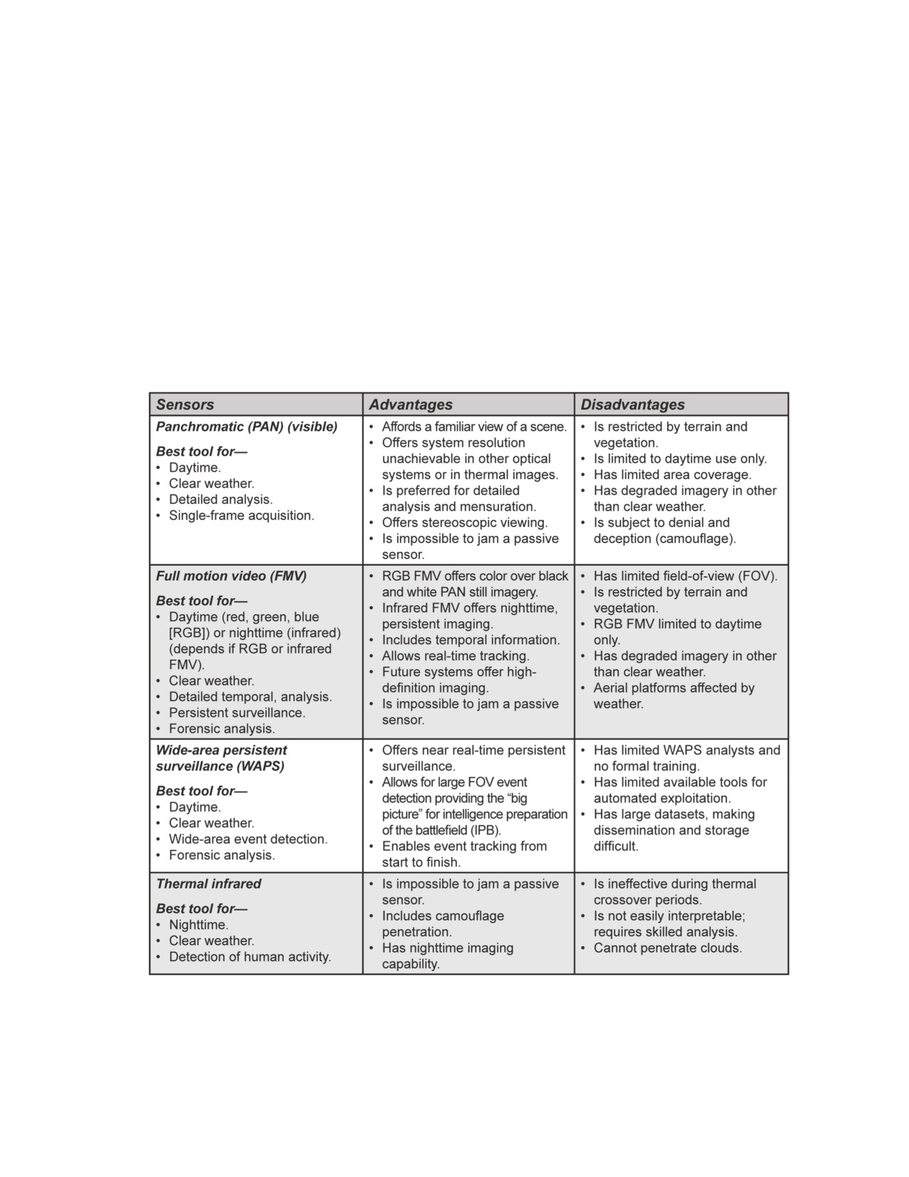
Appendix C
Sensor/Platform Characteristic Matrix
Passive imagery sensors (see table C-1) use natural electromagnetic energy sources,
such as the Sun, naturally occurring radiation, or heat-generating objects. Active
imagery sensors (see table C-2) generate the electromagnetic (manmade) energy
needed to illuminate the object that is being imaged. There is a range of active
imagery sensing capabilities that serve as a powerful complement to standard spectral
imagery.
Table C-1. Passive imagery sensor/platform characteristic matrix
18 February 2011
TC 2-22.7
C-1
FOR OFFICIAL USE ONLY

Appendix C
Table C-2. Active imagery sensor/platform characteristic matrix
C-2
TC 2-22.7
18 February 2011
FOR OFFICIAL USE ONLY

Sensor/Platform Characteristic Matrix
Table C-2. Active imagery sensor/platform characteristic matrix (continued)
18 February 2011
TC 2-22.7
C-3
FOR OFFICIAL USE ONLY
This page intentionally left blank.

Appendix D
GEOINT Training
Geospatial engineers and imagery analysts hold positions in GEOINT cells at the
ASCC, corps, division, and BCT levels. An organization’s mission focus determines
the specific MOS set required to support the commander’s intent in the most efficient
and effective manner.
GEOSPATIAL ENGINEER TRAINING
D-1. Listed in this section are geospatial engineer training courses.
12Y INITIAL ENTRY TRAINING COURSES
D-2. Geospatial engineer initial entry training courses for enlisted personnel are listed in table D-1.
Table D-1. Geospatial engineer 12Y initial entry training courses
18 February 2011
TC 2-22.7
D-1
FOR OFFICIAL USE ONLY

Appendix D
125D WARRANT OFFICER BASIC COURSES
D-3. Geospatial engineering technician warrant officer basic courses are listed in table D-2.
Table D-2. Geospatial engineering technician 125D WOBCs
125D WARRANT OFFICER ADVANCED COURSES
D-4. Geospatial engineering technician warrant officer advanced courses are listed in table D-3.
Table D-3. Geospatial engineering technician 125D WABCs
D-2
TC 2-22.7
18 February 2011
FOR OFFICIAL USE ONLY

GEOINT Training
125D WARRANT OFFICER SENIOR COURSES
D-5. Geospatial engineering technician warrant officer senior courses are listed in table D-4.
Table D-4. Geospatial engineering technician 125D WOSCs
IMAGERY INTELLIGENCE TRAINING
D-6. Listed in this section are IMINT training courses.
35G INITIAL ENTRY TRAINING COURSES
D-7. Imagery analyst initial entry training courses for enlisted Soldiers are listed in table D-5.
Table D-5. Imagery analyst 35G initial entry training courses
35H INITIAL ENTRY TRAINING COURSES
D-8. CGS operator enlisted personnel receive initial entry training in the fundamentals of CGS operations,
operator- or unit-level maintenance, and basic imagery interpretation techniques.
350G WARRANT OFFICER COURSE
D-9. The IMINT technician warrant officer course ensures the IMINT technician is tactically and
technically proficient in managing IMINT collection, analysis, production, and dissemination; IMINT; and
ISR synchronization.
GEOSPATIAL AND IMAGERY TRAINING
D-10. Listed in this section are geospatial and imagery training courses.
ADVANCED GEOSPATIAL ANALYST COURSE
D-11. The Advanced Geospatial Analyst course enhances the understanding of GEOINT capabilities by
providing a fundamental grasp of MASINT/AGI, denial and deception, and imagery manipulation tool
(including software) functionality. The training focuses on when to employ these capabilities, use of
exploitation tools, and situational awareness.
18 February 2011
TC 2-22.7
D-3
FOR OFFICIAL USE ONLY
Appendix D
ADVANCED REMOTELY SENSED IMAGERY COURSE
D-12. The Advanced Remotely Sensed Imagery course is an advanced level course designed to provide
students a solid understanding of advanced spectral imagery processing techniques. The objectives of this
course include—
z
Understanding the advanced functionality of the Earth Resource Data Analysis System
(ERDAS) Imagine software.
z
Understanding basic hyperspectral data and applications.
z
Understanding radar theory, applications, and analysis.
z
Becoming proficient with the use of advanced remotely sensed imagery, processing techniques,
and analysis.
z
Having introductory hyperspectral training with the Environment for Visualizing Images (ENVI)
software.
BASIC OFFICER LEADER COURSE
D-13. The Basic Officer Leader course instructs officer basic skills and knowledge as well as tactical all-
source intelligence officer and MI platoon leader skills and knowledge. Subjects include—
z
The threat.
z
Unit training management.
z
EW.
z
HUMINT.
z
SIGINT.
z
IMINT.
z
Operations security support.
z
Counterintelligence.
z
Tactical all-source intelligence production.
COMMUNITY GEOINT ANALYSIS COURSE
D-14. The Community GEOINT Analysis course (CGAC) is an intermediate GEOINT training course that
augments entry-level training and bridges the gap from identification to analysis. CGAC is open to selected
mid-career noncommissioned officers, warrant officers, and DOD civilians in the geospatial analysis and
imagery tradecraft. CGACs objectives include—
z
Providing intermediate GEOINT analysis training within a geospatial context.
z
Enhancing the geospatial analysis tradecraft at the journeyman level.
z
Focusing on analysis training using multiple sensors and sources in a training environment with
operational exploitation scenarios.
DISTRIBUTED COMMON GROUND SYSTEM-ARMY
D-15. DCGS-A enables—
z
Situational awareness.
z
Identification and location of the threat.
z
Estimates of the threat’s intentions toward the Soldier at all echelons.
z
Exploitation and fusion of data from Army, joint, national, and multinational sensors and
sources to provide actionable intelligence to the Soldier.
D-16. DCGS-A is the Army component of the DOD DCGS family of systems and the ISR component of
battle command. The course teaches individual operator skills to successfully operate the DCGS-A Basic
Analyst Laptop (BAL).
D-4
TC 2-22.7
18 February 2011
FOR OFFICIAL USE ONLY
GEOINT Training
FOUNDRY PROGRAM
D-17. The Foundry Program provides funded, focused, predeployment training to MI Soldiers (Regular
Army and Reserve Component units) or any Soldier serving as an S-2 or S-2 staff at any echelon (18 series
MOSs, geospatial engineers, and military information support operations). The Foundry Program’s three
tenets are—
z
Unit partnership.
z
Functional partnership.
z
Quick-reaction capabilities.
D-18. The Foundry Program trains, through mobile training teams
(MTTs), live environments or
operational training opportunities, home-station training, warfighting-function related certification,
embedded training support, or one-time special training events.
D-19. The Army GEOINT Battalion at NGIC, Washington Navy Yard, Washington, District of Columbia
(DC), is the Foundry Intelligence Training Functional Lead for GEOINT.
GLOBAL BROADCAST SERVICE MOBILE TRAINING TEAM
D-20. GBS MTT provides Soldiers basic skills to employ GBS, with emphasis on setup, maintenance,
cryptology, operations, and GEOINT dissemination.
GEOINT MOBILE TRAINING TEAM-LEADERSHIP
D-21. GEOINT MTT-Leadership training provides a GEOINT orientation and capabilities brief to the
commanders, G-2/S-2, the analysis and control element chief, assistant S-2, S-2 noncommissioned officer
in charge, collection manager, and geospatial and imagery analysts. Additional emphasis is placed on the
following GEOINT applications: WARP, SOCET GXP®, PSS-SOF, FalconView, the Image Product
Library, AGI, and NGA/AGC geospatial support.
GEOINT PRODUCTION COURSE
D-22. The GEOINT Production course is designed for imagery analysts to develop, sustain, refresh, and
enhance MOS skills on current imagery exploitation operational needs. The course places specific
emphasis on the following areas:
z
Imagery systems.
z
Retrieval databases.
z
Research applications.
z
Exploitation tools.
D-23. Course training takes place at the Army GEOINT Battalion, NGIC, Washington Navy Yard,
Washington, DC.
GEOSPATIAL INFORMATION AND SERVICES FOR THE WARRIOR
D-24. The GI&S for the Warrior objectives include—
z
Tailoring the training to the unit.
z
Training on defining basic geodetic terms, including accuracy, datum, and coordinate types.
z
Training on listing geospatial products that can be created or viewed in FalconView, applicable
to mission accomplishment.
z
Creating a geospatial product with a dataset and FalconView software.
z
Identifying applications for FalconView software within the student’s unit mission. (This course
is basically FalconView on the road, a customizable [with time] course.)
18 February 2011
TC 2-22.7
D-5
FOR OFFICIAL USE ONLY
Appendix D
GEOSPATIAL INFORMATION AND SERVICES JOINT STAFF OFFICER COURSE
D-25. The GI&S Joint Staff Officer course provides an overview of key concepts, systems, procedures, and
organizations involved in producing GI&S. The course emphasizes knowledge and skills the commanders,
staffs, and planners need to leverage NGA’s capabilities to support military plans and operations. Course
training objectives include—
z
Identifying aspects of geospatial fundamentals that affect operations.
z
Recognizing GEOINT doctrine and knowing resources available within the NSG to provide
GI&S support to military plans and operations.
z
Comprehending processes and requirements involved in obtaining NGA GI&S products and
services.
z
Appreciating how GI&S and additional programs, such as FalconView, Geographic Translator
(GEOTRANS), and Defense Logistics Agency (DLA) Map Catalog enable mission planning and
terrain visualization.
GLOBAL BROADCAST SERVICE USER COURSE
D-26. The GBS User course is designed to allow Soldiers to deploy the Transportable Ground Receive
Suite (TGRS) to any worldwide conflict. Soldiers receive hands-on training as well as participate in a
capstone for students to use all aspects of training received. Course training objectives include—
z
Soldiers employing GBS to enable commanders to achieve information superiority.
z
Soldiers receiving critical information products, such as imagery, weather, and air-tasking orders
composed of large data files.
D-27. Course training takes place at the Army GEOINT Battalion, NGIC, Washington Navy Yard,
Washington, DC.
IMAGERY EXPLOITATION SUPPORT SYSTEM BASIC IMAGERY ANALYST COURSE
D-28. The IESS Basic Imagery Analyst course is for the imagery exploiter who uses IESS to assist in
tasking imagery exploitation. Topics include—
z
A system overview.
z
Software navigation.
z
Basic and advanced target and image queries.
z
IIR and non-IIR product creation and submission for review and validation.
D-29. Other topics include using the Web-based softcopy client, the Graphical Exploitation Manager
(GEM), to enhance everyday workflow processes, such as discovering and retrieving imagery from a site’s
library and IIR generation. Course training objectives include—
z
Performing basic and advanced target and image research queries against the IESS database.
z
Using IESS and GEM clients to access and retrieve current and historic imagery residing on the
site’s image library.
z
Exercising all capabilities of the GEM.
z
Composing IIR and Non-IIR products in IESS to submit for review and validation.
z
Using the image list function, in conjunction with other query tools, to build and save a list of
current and past imagery and generate softcopy tasking.
IMAGERY ANALYST TRANSITION COURSE
D-30. The Imagery Analyst Transition course trains the 35H CGS operator, who is transitioning to 35G
imagery analyst, in the fundamentals required for effective integration into the 35G MOS.
D-6
TC 2-22.7
18 February 2011
FOR OFFICIAL USE ONLY
GEOINT Training
IMAGERY INTELLIGENCE OFFICER’S COURSE
D-31. The IMINT Officer’s course trains MI officers to manage GEOINT (geospatial information and
IMINT) collection, exploitation, processing, production, and dissemination functions; systems; and
organizations. Army intelligence officers receive a skill identifier of 1D at the completion of the course.
IMAGERY ORIENTATION COURSE
D-32. The Imagery Orientation course is designed to give intelligence professionals an overview of
imagery tools and capabilities. This course covers fundamental tools needed to succeed as an imagery
analyst. It is NOT intended to train non-35Gs to be imagery analysts, rather, to give them an overview of
what imagery analysts need to efficiently complete timely and accurate intelligence products.
D-33. Skills taught during the Imagery Orientation course assist the 35H CGS operator in transitioning to a
35G imagery analyst. It also provides a knowledge base for leaders without imagery analytical capabilities
exposure, so they can readily function in brigade- or battalion-level intelligence or operations positions.
Officers and enlisted personnel working within the GEOINT community benefit from learning the diverse
aspects of IMINT collection, capabilities, and analytical techniques. Course training takes place at the
Army GEOINT Battalion, NGIC, Washington Navy Yard, Washington, DC.
JOINT INTELLIGENCE COMBAT TRAINING CENTER
D-34. The Joint Intelligence Combat Training Center provides tailored battle simulation exercise-based
training to resident courses and visiting intelligence staffs and organizations. The center reinforces
individual MI skills or tasks in a shared collective training environment and hones MI combat-related
commander’s staff skills. GEOINT training comprises LIDAR, GMTI, SOCET GXP®, and ArcGIS.
MILITARY INTELLIGENCE CAPTAIN’S CAREER COURSE
D-35. The MI Captain’s Career course trains MI officers in MI common core, intelligence support to
brigade or battalion operations; intelligence support to division, corps, and joint operations; and intelligence
support to counterinsurgency operations. Course graduates are adaptive and competent leaders prepared to
manage, teach, and lead intelligence Soldiers of the future.
REMOTELY SENSED IMAGERY COURSE
D-36. The Remotely Sensed Imagery course provides education based on commercial, multispectral
imagery with ERDAS Imagine. The objectives of this course are analyzing commercial, multispectral
imagery with ERDAS Imagine software in the following areas:
z
Digital image processing.
z
Landcover classification with multispectral imagery terrain visualization.
z
Analysis tools:
Imagery annotation and product generation.
Hyperspectral imagery concepts.
Multispectral image interpretation.
Imagery importing and preparation.
Imagery concepts and sources overview.
TACTICAL FULL MOTION VIDEO PRODUCTION COURSE
D-37. The Tactical FMV Production course is designed to give intelligence professionals operating within a
BCT a basic awareness and understanding of ISR concepts, tactical FMV roles, and how to conduct or
analyze FMV missions in a counterinsurgency environment. Upon successful completion of this course,
each student is familiar with the following factors as they pertain to tactical FMV missions:
18 February 2011
TC 2-22.7
D-7
FOR OFFICIAL USE ONLY
Appendix D
z
Threat tactics.
z
TTP.
z
Blue force operations.
z
AO cultural features, behaviors, and infrastructure.
D-38. Course training takes place at the Army GEOINT Battalion, NGIC, Washington Navy Yard,
Washington, DC.
TACTICAL EXPLOITATION SYSTEM COURSE
D-39. The Tactical Exploitation System is an operational and theater intelligence and EW asset. The
Combined Arms Training Strategy (CATS) is designed to meet the needs of echelons below corps. CATS
applies to the Tactical Exploitation System because of its ability to provide timely intelligence support to
Army tactical operations. The Tactical Exploitation System integrates hands-on situationally based training
events highlighting operator or leader task and skills analysis.
THE SCHOOL OF GEOSPATIAL INTELLIGENCE
D-40. The National Geospatial-Intelligence College (NGC) provides mission essential training, education,
and professional development services to enable the U.S. global GEOINT mission. Major areas of training
concentration include—
z
Entry-level and intermediate training in terrain analysis and surveying for Armed Services
personnel.
z
GEOINT, analysis, systems, sensors, and related courses.
z
Communications, intelligence, professional studies, supervisory and management skills, and
leadership and executive development.
z
GEOINT-specific acquisition courses.
D-41. NGC serves a broad base of students, including all NGA personnel, members of organizations within
the NSG, other intelligence community personnel, and multinational partners supporting NGA’s
international agreements. The college is accredited by the Council on Occupational Education.
D-8
TC 2-22.7
18 February 2011
FOR OFFICIAL USE ONLY
Appendix E
Support Documents
Support documents covered in this appendix are the Proper Use Memorandum and
electronic target folders.
PROPER USE MEMORANDUM
E-1. Organizations may require new collection or archived imagery of domestic areas to perform certain
missions. Domestic imagery is any imagery collected by satellite (national, commercial, or DOD, including
OPIR) and aircraft platforms that cover the land areas of the 50 states; Washington, DC; and the territories
and possessions of the United States, out to a 12-nautical mile seaward limit of these land areas. A Proper
Use Memorandum that defines the requirements for domestic imagery outlines its intended use and
acknowledges that awareness of legal and policy restrictions regarding domestic imagery must be
submitted to NGA—for NTM and new commercial domestic imagery collection—or to the combatant
command or military Service—for aircraft platform collection.
SUBJECT: Proper Use Statement Memorandum for Exercise XXX
Paragraph 1
State purpose of request, intended use of imagery, location of exercise (military
property; federal [Bureau of Land Management land, national forest], state, or U.S.
territory or possession; or private property), and timeframes for collections.
Paragraph 2
Identify targets. Provide target name, geo-coordinates (latitude and longitude), and
basic encyclopedia (BE) number.
Paragraph 3
List all organizations receiving imagery and derived products. Include desired format
and where imagery will be stored (automated information system). State special
production requirements and security restrictions for softcopy imagery dissemination.
Paragraph 4
Include the following statement:
I certify that the intended use of the requested information, materials, and imagery
derived from classified overhead systems is not in violation of applicable laws,
including the statutory authority of this agency. The request for imagery is not for the
purpose of targeting any specified U.S. person, nor is it inconsistent with the
constitutional and other legal rights of U.S. persons.
Paragraph 5
Certification:
“I am authorized as a certifying official on behalf of
(requesting
command), and I understand I am responsible for the accuracy of the information
contained herein and for the proper safeguarding of products received in response.”
Name, rank/grade, position title, and office.
Note. NGA does not require a Proper Use Memorandum for commercial domestic imagery
unless the requester is asking for a new collect to be paid with NGA funding. Commercial
domestic imagery in the NGA archive does not require a Proper Use Memorandum.
18 February 2011
TC 2-22.7
E-1
FOR OFFICIAL USE ONLY
Appendix E
E-2. The Domestic Imagery Release document is required when the Government obtains imagery of
private property. This may be an individual’s or city’s property. The owner or chief executive of a
municipality must sign the release. (See the following example.)
Private Property Release Statement
I, name of landowner, hereby give my consent for the U.S. Government to take
overhead photographs and collect remote sensing data of my list specific targets, and
surrounding area located at enter street, route, city, state, and to use such
information for U.S. Government purposes. I understand that the photography and
data collection will take place between enter collection dates.
Signature of land owner
E-3. The Army Departmental Requirements Office has Wiki pages on SIPRNET and JWICS listing Army
Proper Use Memorandums for each state.
Note. The Army Departmental Requirements Office produces and maintains Proper Use
Memorandums for almost all major units. Subordinate units can use these Proper Use
Memorandums as long as they are in compliance with them.
E-4. Units and staff organizations performing intelligence activities may not infringe on or violate the
rights of U.S. persons. Collecting information on specific targets inside the United States raises policy and
legal concerns that require careful consideration, analysis, and coordination with legal counsel. Collection
must be in accordance with EO 12333, the National Security Act of 1947, as amended, and DOD 5240.1-R.
E-5.
Acceptable reasons for domestic collection include—
z
Natural disasters.
z
Counterintelligence.
z
Force protection.
z
Security-related vulnerability assessments.
z
Environmental studies.
z
Exercise.
z
Training.
z
Testing.
z
Navigational purposes.
E-6.
When using—
z
National satellites, NGA is responsible for the legal review and approval of requests for the
collection and dissemination of domestic imagery.
z
Airborne platforms, an approved Proper Use Memorandum must be on file with the
appropriate combatant command or military Service before they can be tasked to collect
domestic imagery.
z
Commercial imagery, intelligence components can obtain domestic commercial imagery
without higher level approval for valid mission purposes, such as training or testing on federally
owned and operated ranges, calibration-associated systems development activities, and domestic
disaster relief operations.
z
UASs for navigational or target training activities, UASs may collect imagery during formal and
training missions as long as the collected imagery is not for the purpose of obtaining information
about specific U.S. persons or private property.
E-2
TC 2-22.7
18 February 2011
FOR OFFICIAL USE ONLY

Support Documents
ELECTRONIC TARGET FOLDER
E-7. The electronic target folder items in table E-1 are provided as an example. Actual target folder items
may or may not be included as the specific needs of the target are defined.
Table E-1. Sample electronic target folder items
18 February 2011
TC 2-22.7
E-3
FOR OFFICIAL USE ONLY
This page intentionally left blank.
Glossary
SECTION I - ACRONYMS AND ABBREVIATIONS
2D
two-dimensional
3D
three-dimensional
10 USC 467
Section 467, Title 10, United States Code
ABCS
Army Battle Command System
AGC
Army Geospatial Center
AGO
Army Geospatial Intelligence Office
AGI
advanced geospatial intelligence
AMRDS
AGI and MASINT Reporting and Dissemination Service
AO
area of operations
AR
Army regulation
ARL
Airborne Reconnaissance Low
ArcGIS
Arc Geographic Information System
ARMS
Airborne Reconnaissance Multisensor System
ASCC
Army Service component command
ATTP
Army tactics, techniques, and procedures
BCT
brigade combat team
BFSB
battlefield surveillance brigade
CALA
Community Airborne Library Architecture
CCIR
commander’s critical information requirement
CGS
common ground station
CIA
Central Intelligence Agency
CIB
controlled image base
CJTF
combined joint task force
COA
course of action
COP
common operational picture
DCGS
Distributed Common Ground System
DCGS-A
Distributed Common Ground System-Army
DIA
Defense Intelligence Agency
DOD
Department of Defense
DODD
Department of Defense directive
EMARSS
Enhanced-Medium Altitude Reconnaissance and Surveillance System
EO 12333
Executive Order 12333
ERDAS
Earth Resource Data Analysis System
EW
electronic warfare
18 February 2011
TC 2-22.7
Glossary-1
FOR OFFICIAL USE ONLY
Glossary
FLIR
forward looking infrared
FM
field manual
FMI
field manual interim
FMV
full motion video
G-2
assistant chief of staff, intelligence
G-3
assistant chief of staff, operations
G-6
assistant chief of staff, signal
GBS
Global Broadcast Service
GEOINT
geospatial intelligence
GI&S
geospatial information and services
GMI
general military intelligence
GMTI
ground moving target indicator
GPC
geospatial planning cell
HUMINT
human intelligence
I&W
indications and warning
IESS
Imagery Exploitation Support System
IFSAR
interferometric synthetic aperture radar
IIR
imagery interpretation report
IMINT
imagery intelligence
INSCOM
United States Army Intelligence and Security Command
IPB
intelligence preparation of the battlefield
IR
infrared
ISR
intelligence, surveillance, and reconnaissance
J-2
intelligence directorate of a joint staff
J-3
operations directorate of a joint staff
JFC
joint force commander
JP
joint publication
JSTARS
Joint Surveillance Target Attack Radar System
JTF
joint task force
JWICS
Joint Worldwide Intelligence Communications System
LIDAR
light detection and ranging
LWIR
long-wave infrared
MARSS
Medium Altitude Reconnaissance and Surveillance System
MASINT
measurement and signature intelligence
MCIA
Marine Corps Intelligence Activity
MDMP
military decisionmaking process
MI
military intelligence
MOS
military occupational specialty
MTI
moving target indicator
MWIR
medium-wave infrared
Glossary-2
TC 2-22.7
18 February 2011
FOR OFFICIAL USE ONLY
Glossary
NASIC
National Air and Space Intelligence Center
NGA
National Geospatial-Intelligence Agency
NGIC
National Ground Intelligence Center
NIPRNET
Nonsecure Internet Protocol Router Network
NRO
National Reconnaissance Office
NSA
National Security Agency
NSG
National System for Geospatial Intelligence
NTM
national technical means
ONI
Office of Naval Intelligence
OPIR
overhead persistent infrared
PSS-SOF
Precision Strike Suite for Special Operations Forces
RFI
request for information
S-2
intelligence staff officer
S-3
operations staff officer
S-6
signal staff officer
SAR
synthetic aperture radar
SIGINT
signals intelligence
SIPRNET
SECRET Internet Protocol Router Network
SOCET GXP
Softcopy Exploitation Toolkit Geospatial Exploitation Product
S&TI
scientific and technical intelligence
TC
training circular
TCPED
tasking, collection, processing, exploitation, and dissemination
TGD
Theater Geospatial Database
UAS
unmanned aircraft system
USAF
United States Air Force
WARP
web-accessed retrieval portal
SECTION II - TERMS
geospatial information and services
Information that identifies the geographic location and characteristics of natural or constructed features
and boundaries on the Earth, including: statistical data and information derived from, among other
things, remote sensing, mapping, and surveying technologies; and mapping, charting, geodetic data,
and related products. (10 USC 467)
geospatial intelligence
The exploitation and analysis of imagery and geospatial information to describe, assess, and visually
depict physical features and geographically referenced activities on the Earth. Geospatial intelligence
consists of imagery, imagery intelligence, and geospatial information. (10 USC 467)
18 February 2011
TC 2-22.7
Glossary-3
FOR OFFICIAL USE ONLY
Glossary
imagery
The likeness or presentation of any natural or manmade feature or related object or activity, and the
positional data acquired at the same time the likeness or representation was acquired, including:
products produced by space-based national intelligence reconnaissance systems; and likenesses and
presentations produced by satellites, aircraft platforms, unmanned aircraft vehicles, or other similar
means (except that such term does not include handheld or clandestine photography taken by or on
behalf of human intelligence collection organizations). (10 USC 467)
imagery intelligence
The technical, geographic, and intelligence information derived through the interpretation or analysis
of imagery and collateral materials. (10 USC 467)
Glossary-4
TC 2-22.7
18 February 2011
FOR OFFICIAL USE ONLY
References
REQUIRED PUBLICATIONS
These documents must be available to the intended users of this publication.
FM 1-02. Operational Terms and Graphics. 21 September 2004.
FM 2-0. Intelligence. 23 March 2010.
JP 1-02. Department of Defense Dictionary of Military and Associated Terms. 8 November 2010 (As
Amended Through 31 December 2010).
RELATED PUBLICATIONS
These sources contain relevant supplemental information.
10 USC 467. Armed Forces: Definitions. Available online at
http://www.gpoaccess.gov/uscode/browse.html.
AR 115-11. Geospatial Information and Services. 10 December 2001.
ATTP 3-34.80. Geospatial Engineering. 24 July 2010.
DOD 5240.1-R. Procedures Governing the Activities of DOD Intelligence Components That Affect
United States Persons. 1 December 1982.
DODD 5105.60. National Geospatial-Intelligence Agency (NGA). 29 July 2009.
EO 12333. United States Intelligence Activities. 4 December 1981.
FM 2-01.3. Intelligence Preparation of the Battlefield/Battlespace. 15 October 2009.
FM 3-0. Operations. 27 February 2008.
FM 3-34.170. Engineering Reconnaissance. 25 March 2008.
FM 3-36. Electronic Warfare in Operations. 25 February 2009.
FM 3-90. Tactics. 4 July 2001.
FM 5-0. The Operations Process. 26 March 2010.
FM 5-19. Composite Risk Management. 21 August 2006.
FMI 2-01.301. Specific Tactics, Techniques, and Procedures for Intelligence Preparation of the
Battlefield. 31 March 2009.
JP 2-0. Joint Intelligence. 22 June 2007.
JP 2-01. Joint and National Intelligence Support to Military Operations. 7 October 2004.
JP 2-03. Geospatial Intelligence Support to Joint Operations. 22 March 2007.
JP 3-0. Joint Operations. 17 September 2006 (Change 2, 22 March 2010).
JP 3-16. Multinational Operations. 7 March 2007.
JP 3-28. Civil Support. 14 September 2007.
JP 3-34. Engineer Doctrine for Joint Operations. 12 February 2007.
JP 3-60. Joint Doctrine for Targeting. 13 April 2007.
JP 4-0. Joint Logistics. 18 July 2008.
JP 5-0. Joint Operation Planning. 26 December 2006.
JP 6-0. Joint Communications System. 10 June 2010.
MISB: Motion Imagery Standards Board. Available online at http://www.gwg.nga.mil/misb/.
National Security Act of 1947. Available online at
http://www.state.gov/www/about_state/history/intel/intro6.html.
18 February 2011
TC 2-22.7
References-1
FOR OFFICIAL USE ONLY
References
NSG: Geospatial Intelligence (GEOINT) Basic Doctrine Publication 1-0. NGA. September 2006.
TC 2-01. Intelligence, Surveillance, and Reconnaissance Synchronization. 22 September 2010.
TC 2-33.4. Intelligence Analysis. 1 July 2009.
U.S. Constitution. Available online at http://www.archives.gov/exhibits/charters/constitution.html.
PRESCRIBED FORMS
None.
REFERENCED FORMS
DA Form 2028. Recommended Changes to Publications and Blank Forms.
References-2
TC 2-22.7
18 February 2011
FOR OFFICIAL USE ONLY
Index
Entries are by paragraph number.
A
Army organizations
combatant commands, 1-44
ABCS, 1-42
Army corps, 5-42 through
through 1-48.
5-45.
active imagery sensors, 2-73,
commercial systems, 2-6
Army division, 5-46 through
2-74, table C-2. See also
through 2-8. See also
5-49.
imagery, sensors.
dissemination; satellite
Army Service component
systems.
advanced geospatial
command, 5-38 through
intelligence. See AGI.
commercial tasking, 3-15. See
5-41.
also imagery, tasking.
AGC, 1-42, 1-43. See also
Army special operations
NSG, Army organizations
forces, 5-59 through 5-63
Constant Hawk, 2-25. See also
that support.
battlefield surveillance
manned aircraft systems.
AGI, 1-37, 2-62 through 2-65.
brigade, 5-53.
controlled image base, 2-52,
See also still imagery.
brigade combat team, 5-54
2-53. See also panchromatic
analyst; IMINT team.
through 5-58.
imagery.
theater military intelligence
AGO, 1-40, 1-4. See also NSG,
counterintelligence, 1-59, 1-60.
brigade, 5-50 through
Army organizations that
See also intelligence
5-52.
support.
products, categories of.
Army Special Programs Office.
Airborne Reconnaissance Low.
course of action. See COA.
See ASPO.
See ARL.
current intelligence, 1-53. See
ASG. See NGA.
Airborne Reconnaissance
also intelligence products,
Multisensor System. See
ASPO, 1-33. See also NSG,
categories of.
ARMS.
Army organizations that
D
support.
aircraft systems, 2-10 through
assess. See geospatial
data sources
2-13. See also
3D modeling capability,
dissemination; imagery,
engineer, operations
4-48.
sources.
process.
dynamic terrain
aircraft tasking, 3-17 through
B
visualization, 4-45.
3-19. See also imagery,
BuckEye, 2-54. See also
feature data, 4-44.
tasking.
panchromatic imagery.
IFSAR, 4-40.
Allied System for GEOINT. See
LIDAR, 4-41 through 4-43.
C
ASG.
motion imagery, 4-46, 4-47.
Central Intelligence Agency.
all-source intelligence, 1-53.
DCGS-A, B-1, B-2, D-15, D-16.
See CIA.
analysis and production. See
Defense Intelligence Agency.
CIA, 1-27.
GEOINT activities.
See DIA.
civil support operations, 6-28
ARL, 2-22. See also manned
defensive operations, 6-14
through 6-30. See also
aircraft systems.
through 6-16. See also
GEOINT, support to
GEOINT, support to
ARMS, 2-23. See also manned
operations.
operations.
aircraft systems.
COA
Department of Defense. See
Army Battle Command System.
analysis (war-gaming). See
DOD.
See ABCS.
MDMP, steps of.
DIA, 122. See also NSG,
Army Geospatial Center. See
approval. See MDMP, steps
national organizations that
AGC.
of.
support.
Army Geospatial Intelligence
development. See MDMP,
steps of.
dissemination. See GEOINT
Office. See AGO.
activities.
collection. See GEOINT
activities.
Distributed Common Ground
System-Army. See DCGS-A.
18 February 2011
TC 2-22.7
Index-1
FOR OFFICIAL USE ONLY
Index
Entries are by paragraph number.
DOD, 1-28
support to planning, 6-1
support to situational
through 6-5.
understanding, 4-10,
E
support to special
4-11.
electronic target folder, E-7
operations, 6-32, 6-33.
team. See GEOINT, cell
EMARSS, 2-26. See also
GEOINT activities, 5-9 through
manning.
manned aircraft systems.
5-11.
terrain visualization, 4-7
Enhanced Medium Altitude
analysis and production,
geospatial engineering.
Reconnaissance and
5-21 through 5-24.
technician. See geospatial
Surveillance System. See
collection, 5-14.
engineer, team.
EMARSS.
dissemination, 5-25 through
geospatial information. See
5-35.
environmental assistance,
geospatial engineer.
evaluation and feedback,
6-27. See also stability
geospatial information and
5-36.
operations.
services. See GI&S.
planning and direction,
estimative intelligence, 1-61.
geospatial intelligence. See
5-12, 5-13.
See also intelligence
processing and exploitation,
GEOINT.
products, categories of.
5-15 through 5-20.
geospatial planning cell. See
evaluation and feedback. See
GPC.
GEOINT cell, 5-1 through 5-8,
GEOINT activities.
6-38 through 6-41, 6-43.
GI&S, 1-4, 4-1.
execute. See geospatial
mission analysis, A-10,
Global Broadcast Service,
engineer, operations
A-12, A-18, A-20, A-32
5-30.
process.
through A-35, A-37, A-40,
A-41, A-43 through A-45,
Global Information Grid, B-3,
F
B-4.
A-47.
feature data. See data sources.
receipt of mission, A-9.
GMI, 1-54, 1-55.
FMV, 2-67. See also motion
support to the warfighting
ground reconnaissance, 2-37.
imagery.
functions, 5-38, 5-45,
See also handheld imagery.
5-50, 5-59.
full motion video. See FMV.
ground sample distance. See
geospatial data management
imagery, resolution.
G
digital geospatial data, 4-32.
general military intelligence.
GPC, 4-35 through 4-38.
H
See GMI.
TGD, 4-33, 4-34.
handheld imagery, 2-36. See
GEOINT
geospatial engineer, 5-74.
also imagery, sources.
and intelligence products,
applied to the warfighting
humanitarian assistance, 6-21
1-49.
functions, 4-18.
through 6-26. See also
cell manning. See GEOINT,
defined, 4-3.
stability operations.
personnel duties and
functions of, 4-4.
hyperspectral imagery. See
responsibilities.
GEOINT training. See
spectral imagery.
consists of, 1-1
training.
definition, 1-1
geospatial information, 4-5,
I
layered data, 1-5 through
4-6.
I&W. 1-51, 1-52. See also
1-9.
integrated into composite
intelligence products,
personnel duties and
risk management, 4-29.
categories of.
responsibilities, 5-64
integrated into ISR
IFSAR. See data sources.
through 5-74.
synchronization, 4-27.
products, 5-23, 5-24, 6-44
integrated into knowledge
imagery
through 6-47, A-1
management, 4-30.
definition, 1-2
through A-3.
integrated into the IPB
requirements management,
support to combatant
process, 4-19 through
3-3 through 3-9.
commands, 1-44
4-23.
resolution, 2-39 through
support to host nations,
integrated into the targeting
2-46.
6-46, 6-47.
process, 4-24 through
sensors, 2-70, 2-71.
support to joint operations,
4-26.
sources, 2-1.
6-34 through 6-43.
operations process, 4-12
tasking, 3-10, 3-11.
support to multinational
through 4-17.
types, 2-47.
operations, 6-44, 6-45.
support to GEOINT,
imagery analyst, 5-70. See
support to operations, 6-6
4-8, 4-9.
also IMINT team.
through 6-30.
support to planning,
IMINT training. See training.
6-1, 6-2.
Index-2
TC 2-22.7
18 February 2011
FOR OFFICIAL USE ONLY
Index
Entries are by paragraph number.
support to planning, 6-1.
use and share GEOINT,
National Geospatial-
6-42.
Intelligence College. See
imagery intelligence. See
training.
IMINT.
Joint Surveillance Target
Attack Radar System. See
National Ground Intelligence
IMINT
JSTARS.
Center. See NGIC.
definition, 1-3
products, 3-29
JSTARS, 2-15 through 2-21.
National Imagery
reports, 3-28
See also manned aircraft
Interpretability Rating Scale.
role of, 3-1, 3-2
systems.
See NIIRS.
technician. See IMINT
national intelligence support
L
team.
team. See NIST.
LIDAR, 2-73. See also data
IMINT production
National Reconnaissance
sources; BuckEye.
national strategic level, 3-21
Office. See NRO.
operational level, 3-23, 3-24
light detection and ranging.
National Security Agency. See
tactical level, 3-25, 3-26
See LIDAR.
NSA.
theater strategic level, 3-22.
M
National System for Geospatial
IMINT team. See GEOINT, cell
manned aircraft systems, 2-14,
Intelligence. See NSG.
manning.
2-28.
national systems. See
impulse response. See
Marine Corps Intelligence
dissemination.
imagery, resolution.
Activity. See MCIA.
national technical means, 2-5.
indications and warning. See
MARSS, 2-24. See also
See also satellite systems.
I&W.
manned aircraft systems.
national-level tasking, 3-12
infrared. See IR.
MCIA, 1-29. See also NSG,
through 3-14. See also
INSCOM, 1-34
national organizations that
imagery, tasking.
intelligence preparation of the
support.
NGA, 1-14, 1-15. See also
battlefield. See IPB.
MDMP, steps of, A-8 through
NSG, national organizations
intelligence products, 1-49,
A-55. See also operation
that support.
1-50.
plan; operation order.
ASG, 1-16
intelligence, surveillance, and
Medium Altitude
NGA support team, 1-18
reconnaissance. See ISR.
Reconnaissance and
through 1-20
Surveillance System. See
NIST, 1-21
interferometric synthetic
MARSS.
portals, 5-27 through 5-29.
aperture radar. See IFSAR.
military decisionmaking
NGIC, 1-34 through 1-39. See
IPB, 6-10, 6-11
process. See MDMP.
also NSG, Army
mission analysis, A-13
organizations that support.
through A-17
mission analysis, A-11 through
core competencies, 1-35.
process, 4-19
A-47. See also MDMP, steps
products, 6-18.
of.
NIIRS, 2-43 through 2-45
IR imagery, 2-55 through 2-58.
motion imagery, 2-66 through
NIST. See NGA.
See also passive imagery
2-69. See also data sources.
NRO, 1-27. See also NSG,
sensors; still imagery.
MQ-1C Gray Eagle. See UAS.
national organizations that
support.
ISR, 6-12.
MQ-5B Hunter. See UAS.
NSA, 1-24. See also NSG,
J
MQ-9 Reaper. See UAS.
national organizations that
joint intelligence architecture,
multispectral imagery, 2-50.
support.
3-32, 3-33.
See also spectral imagery.
NSG, 1-10 through 1-12, 1-47
joint operations activities
N
Army organizations that
supported by GEOINT
support, 1-32
NASIC, 1-30. See also NSG,
define GEOINT
national organizations that
national organizations that
requirements, 6-38
support, 1-13.
support.
evaluate GEOINT content
National Air and Space
O
and form, 6-40, 6-41
Intelligence Center. See
maintain GEOINT data,
offensive operations, 6-10
NASIC.
6-43
through 6-13. See also
obtain mission-essential
National Geospatial-
GEOINT, support to
GEOINT, 6-39
Intelligence Agency. See
operations.
NGA.
18 February 2011
TC 2-22.7
Index-3
FOR OFFICIAL USE ONLY
Index
Entries are by paragraph number.
Office of Naval Intelligence.
R
targeting, 4-24 through 4-26.
See ONI.
radar imagery, 2-59 through 2-
temporal resolution. See
ONI, 1-28. See also NSG,
61, 2-73. See also still
imagery, resolution.
national organizations that
imagery.
terrain analysis, 4-49 through
support.
radiometric resolution. See
4-52.
open-source intelligence, 2-38.
imagery, resolution.
terrain visualization. See
See also handheld imagery.
receipt of mission. See MDMP,
geospatial engineer.
operation order, A-4, A-6
steps of.
dynamic. See data sources.
development via the MDMP,
resolution. See imagery,
Theater Geospatial Database.
A-8.
resolution.
See TGD.
operation plan, A-5, A-6
RQ-11B Raven. See UAS.
three-dimensional. See 3D.
development via the MDMP,
RQ-4A Global Hawk. See UAS.
training
A-8.
geospatial and imagery
RQ-7B Shadow. See UAS.
operations process. See
training, D-10 through
geospatial engineer.
S
D-42.
OPIR, 2-9. See also satellite
S&TI, 1-57, 1-58. See also
geospatial engineer
systems.
intelligence products,
training, D-1 through D-5.
categories of.
imagery analyst,
orders production. See MDMP,
D-6 through D-9.
steps of.
satellite systems, 2-2 through
National Geospatial-
overhead persistent infrared.
2-9. See also imagery,
Intelligence College,
See OPIR.
sources.
D-43, D-44.
scientific and technical
P
intelligence. See S&TI.
U
panchromatic imagery, 2-49
SIGINT, 1-2.
U.S. Army Intelligence and
through 2-51. See also
Security Command. See
passive imagery sensors;
signals intelligence. See
INSCOM.
still imagery.
SIGINT.
U-2, 2-15, 2-16. See also
passive imagery sensor, 2-72,
spatial resolution. See imagery,
manned aircraft systems.
table C-1. See also imagery,
resolution.
unmanned aircraft system. See
sensors.
spectral imagery, 2-64. See
UAS.
plan. See geospatial engineer,
also passive imagery
operations process.
sensors; AGI.
ultra-spectral imagery. See
spectral imagery.
planning and direction. See
spectral resolution. See
GEOINT activities.
imagery, resolution.
UAS, 2-29 through 2-35.
prepare. See geospatial
stability operations, 6-17
W
engineer, operations
through 6-20. See also
warfighting functions, A-17
process.
GEOINT, support to
through A-28. See also
operations.
processing and exploitation.
GEOINT cell; geospatial
See GEOINT activities.
still imagery, 2-48. See also
engineer.
imagery, types.
Project Liberty, 2-27. See also
Warrior Alpha. See UAS.
manned aircraft systems.
T
Proper Use Memorandum, E-1
target intelligence, 1-56. See
through E-6.
also intelligence products,
categories of.
Index-4
TC 2-22.7
18 February 2011
FOR OFFICIAL USE ONLY
TC 2-22.7
18 February 2011
By order of the Secretary of the Army:
GEORGE W. CASEY, JR.
General, United States Army
Chief of Staff
Official:
JOYCE E. MORROW
Administrative Assistant to the
Secretary of the Army
1102102
DISTRIBUTION:
Active Army, Army National Guard, and United States Army Reserve: Not to be distributed;
electronic media only.
FOR OFFICIAL USE ONLY
PIN: 100759-000
FOR OFFICIAL USE ONLY
FM 3-13
25 October 2011
Inform and Influence Activities
Final Draft—Not for Implementation
DISTRIBUTION RESTRICTION. The material in this publication is under development. It is NOT approved doctrine and
CANNOT be used for reference or citation. The approved FM is still current and must be used for reference, or citation,
until this draft is approved and authenticated. Upon publication, this manual will be approved for public release;
distribution will be unlimited.
Headquarters, Department of the Army
*FM 3-13
Field Manual
Headquarters
Department of the Army
No. 3-13
Washington, DC, (25 October 2011)
Inform and Influence Activities
FINAL DRAFT—NOT FOR IMPLEMENTATION
Contents
Page
PREFACE
iii
INTRODUCTION
iv
Chapter 1
CONSTRUCT OF INFORM AND INFLUENCE ACTIVITIES
1-1
Inform and Influence Activities Defined
1-1
Inform and Influence Activities Considerations
1-3
Chapter 2
ASPECTS OF INFORM AND INFLUENCE ACTIVITIES
2-1
Integrating Activity
2-1
Lines of Effort
2-2
Information Environment
2-2
Joint Information Operations and Strategic Communication
2-4
Commander’s Means
2-5
Offensive and Defensive Operations
2-5
Chapter 3
CAPABILITIES OF INFORM AND INFLUENCE ACTIVITIES
3-1
Information-Related Capabilities
3-1
Integrated and Synchronized Capabilities
3-5
Chapter 4
ROLES, RESPONSIBILITIES, AND ORGANIZATIONS
4-1
Role of the Commander
4-1
Role of the G-7 (S-7) Officer
4-1
Role of the Staff
4-2
Role of Others
4-3
Chapter 5
INFORM AND INFLUENCE ACTIVITIES INTEGRATION
5-1
Inform and Influence Activities as an Integrating Function
5-1
Inform and Influence Activities and the Military Decisionmaking Process
5-1
Chapter 6
SOLDIER AND LEADER ENGAGEMENT
6-1
Distribution Restriction: The material in this publication is under development. It is NOT approved doctrine and
CANNOT be used for reference or citation. The approved FM is still current and must be used for reference, or
citation, until this draft is approved and authenticated. Upon publication, this manual will be approved for public
release; distribution will be unlimited.
* When published, this publication will supersede FM 3-13, 28 November 2003.
i
Contents
Definition of Soldier and Leader Engagement
6-1
Principles of Soldier and Leader Engagement
6-1
Types of Soldier and Leader Engagement
6-3
Role of the Commander in Soldier and Leader Engagement
6-4
Role of the Staff in Soldier and Leader Engagement
6-6
Appendix A WORKING GROUP
A-1
Appendix B RUNNING ESTIMATE
B-1
Appendix C ASSESSMENT
C-1
Appendix D DELIBERATE ENGAGEMENT
D-1
GLOSSARY
Glossary-1
REFERENCES
References-1
INDEX
Index-1
Figures
Figure 2-1. Integrating inform and influence activities
2-1
Figure 2-2. Information environment
2-3
Figure 5-1. The MDMP from an inform and influence activities perspective
5-2
Figure A-1. Potential members of inform and influence activities working group
A-1
Figure A-2. The Army targeting methodology
A-2
Figure A-3. Example of synchronization matrix
A-4
Figure B-1. Sample running estimate format for inform and influence activities
B-2
Figure C-1. Sample MOE and MOP development
C-2
Figure C-2. Assessment methodology for the information objective
C-4
ii
FM 3-13 (FD—NOT FOR IMPLEMENTATION)
25 October 2011
1
Preface
2
Field manual (FM) 3-13 is one of the Army’s supporting doctrinal publications. FM 3-13 presents overarching
3
doctrinal guidance and direction for conducting inform and influence activities and the importance of the
4
information environment to commanders and staffs. It constitutes the Army’s view of how it supports
5
information operations in all the domains. It develops the other principles, tactics, and procedures detailed in
6
subordinate doctrinal publications.
7
8
The manual does not address every information-related capability commanders can use to help shape their
9
complex operational environment. It should, however, generate introspection and provide just enough guidance
10
to facilitate flexibility and innovative approaches for the commander to execute the art and science of command
11
in order to inform and influence, and for the staff to integrate and conduct inform and influence activities by
12
bringing any and all capabilities to bear, as determined, to achieve the desired effects in support of the
13
commander’s objectives and intent.
14
FM 3-13 uses joint terms where applicable. Most terms with joint or Army definitions are in both the glossary
15
and the text. Terms for which FM 3-13 is the proponent publication (the authority) have an asterisk in the
16
glossary. Definitions for which FM 3-13 is the proponent publication are in boldfaced text. These terms and
17
their definitions will be in the next revision of FM 1-02. For other definitions in the text, the term is italicized
18
and the number of the proponent publication follows the definition.
19
The principal audience for FM 3-13 is commanders and staffs at all echelons of command. FM 3-13 applies to
20
the Active Army, Army National Guard/Army National Guard of the United States, and U.S. Army Reserve
21
unless otherwise stated.
22
Headquarters, U.S. Army Training and Doctrine Command, is the proponent for this publication. The preparing
23
agency is the Combined Arms Doctrine Directorate, U.S. Army Combined Arms Center. Send written
24
comments and recommendations on a DA Form 2028 (Recommended Changes to Publications and Blank
25
Forms) to Commander, U.S. Army Combined Arms Center and Fort Leavenworth, ATTN: ATZL-MCK-D
26
(FM 3-13),
300 McPherson Avenue, Fort Leavenworth, KS
66027-2337; by e-mail to
27
usarmy.leavenworth.mccoe.mbx.cadd-org-mailbox@mail.mil; or submit an electronic DA Form 2028.
28
25 October 2011
FM 3-13 (FD—NOT FOR IMPLEMENTATION)
iii
1
Introduction
2
The shift from information operations concept, tactics, and definitions occurred when field manual (FM) 3-0,
3
Change 1 unburdened information operations for the Army and established the new mission command
4
warfighting function and concept. Mission command established both a commander’s task to lead and a staff
5
task to conduct inform and influence activities, along with a staff task to conduct cyber electromagnetic
6
activities. At the same time, the Secretary of Defense and joint staff adapted the definition and construct of
7
information operations and capabilities that support it. The result formed the information proponent office and
8
the information as discussed in this field manual.
9
Information-related capabilities have replaced the components and enablers of inform and influence activities
10
published as part of Change 1, FM 3-0 Operations. The Commanding General, Combined Arms Center
11
approved this replacement to better align with joint doctrine.
12
Another change is responsibility for daily execution of several of the information-related capabilities. The FA30
13
information operations officer still primarily integrates the information-related capabilities for the commander.
14
This integration shapes the information environment and supports the commander’s objectives for the
15
operational environment. However, the responsibility for daily execution of capabilities has now fallen on
16
others, such as the protection cell for operations security and cyber electromagnetic activities section for
17
electronic warfare. What has not changed is the G-7’s, inform and influence activities section’s, close
18
relationship and coordination with both those and the other staff sections. Together they integrate, coordinate,
19
and synchronize information-related capabilities into the commander’s overarching operation plan.
20
Based on current doctrinal changes, the following terms have been added, modified, or rescinded for purposed
21
of this manual:
22
Term
Definition
Action
computer network
Enabling operations and intelligence collection to
RESCIND - is FM 3-XX
exploitation
gather data from target or adversary automated
new proponent (This
information systems or networks.
definition is consistent
with joint initiatives and is
being staffed as a
possible joint definition.)
computer network
Computer network attack, computer network
RESCIND -FM 3-XX
operations
defense, and related computer network
new proponent (This
exploitation enabling operations.
definition is consistent
with joint initiatives and is
being staffed as a
possible joint definition.)
critical asset list
A list of intelligence, surveillance, and
RESCIND
reconnaissance elements, and elements of the
command’s command and control system, whose
loss or functional disruption would jeopardize
mission accomplishment.
deceive
To cause a person to believe what is not true.
MODIFY
deception working
A group tailored to bring together the special
RESCIND
group
technical skills required to conduct a specific
military deception operation.
defense in depth
In information operations, the integration of the
RESCIND
capabilities of people, operations, and technology
to establish multi-layer, multidimension protection.
25 October 2011
FM 3-13 (FD—NOT FOR IMPLEMENTATION)
iv
Introduction
degrade
To use nonlethal or temporary means to reduce
MODIFY
the effectiveness or efficiency of targeted
information system and information collection
efforts or means.
deny
To withhold information about friendly forces,
MODIFY
operations, or situations that can be used by the
adversary and enemy.
destroy
To use lethal and nonlethal means to physically
MODIFY
render enemy information useless or information
systems ineffective unless reconstituted.
detect
To discover or discern the existence, presence, or
KEEP
fact of an intrusion into information systems.
disinformation
Information disseminated primarily by intelligence
RESCIND
organizations or other covert agencies designed
to distort information, or deceive or influence
United States decisionmakers, United States
forces, coalition allies, key actors, or individuals
by indirect or unconventional means.
disrupt
To break or interrupt the flow of information
MODIFY
between selected command nodes and control
nodes.
exploit
To gain access to targeted information networks
MODIFY
to collect information or to insert false or
misleading information.
feedback
Information that reveals how the deception target
RESCIND
is responding to the deception story and if the
military deception plan is working.
field support team
A mission-tailored team of subject matter experts
ADD
that provides direct support for information
operations or inform and influence activities to the
ARFORs and joint task forces of land components
of combatant commands, and corps and divisions
as requested.
forms of uncertainty
In military deception, means of shaping the
RESCIND
deception target’s perceptions. Increasing
uncertainty aims to confuse the deception target.
Reducing uncertainty aims to reinforce the
deception target’s predispositions.
indicator feedback
Information that indicates whether and how the
RESCIND
deception story is reaching the deception target.
influence
To cause audiences to think or behave in a
MODIFY
manner favorable to the commander’s objectives.
inform and influence
The integration of designated information-related
ADD
activities
capabilities in order to synchronize themes,
messages, and actions with operations to inform
U.S. and global audiences, influence foreign
audiences, and affect adversary and enemy
decisionmaking.
information fratricide
The result of employing information-related
MODIFY
capabilities operations elements in a way that
causes effects in the information environment that
impede the conduct of friendly operations or
adversely affect friendly forces.
information
Organic, assigned and attached units with
RESCIND
operations assets
information operations capabilities.
25 October 2011
FM 3-13 (FD—NOT FOR IMPLEMENTATION)
v
Introduction
information
Units or systems that support the accomplishment
RESCIND
operations
of information operations tasks.
capabilities
information
A grouping of staff officers to synchronize
RESCIND
operations cell
information operations throughout the operations
process.
information
A clear, concise statement of where, when, and
RESCIND
operations concept of
how the commander intends to focus the
support
information element of combat power to
accomplish the mission.
information
A short paragraph or sentence describing what
RESCIND
operations mission
the commander wants information operations to
statement
accomplish and the purpose for accomplishing it.
information
Clearly defined, obtainable aims that the
RESCIND
operations objectives
commander intends to achieve using information
operations elements/related activities.
information
Information-operations-capable units not assigned
RESCIND
operations resources
or attached to the command, but whose
capabilities are available to conduct information
operations
information
Tasks developed to support accomplishment of
RESCIND
operations tasks
one or more information operations objectives.
information
Deficiencies in protective measures that may
RESCIND
operations
allow an adversary to use information operations
vulnerabilities
capabilities against friendly information systems or
command and control systems.
information
A team designed to enhance army force
RESCIND
operations
protection through the Army commander’s ability
vulnerability
to incorporate defensive information operations
assessment team
into peacetime operations, operational and
contingency missions, training and exercises.
misinformation
Incorrect information from any source that is
RESCIND
released for unknown reasons or to solicit a
response or interest from a nonpolitical or
nonmilitary target.
operations security
(Army) A process of identifying essential elements
RESCIND Army
of friendly information and subsequent analyzing
definition. JP 3-13.3
friendly actions attendant to military operations
proponent for joint
and other activities to: a. identify those actions
definition which suffices
that can be observed by adversary intelligence
systems; b. determine indicators hostile
intelligence systems might obtain that could be
interpreted or pieced together to derive critical
information in time to be useful to adversaries;
and c. select and execute measures that eliminate
or reduce to an acceptable level the vulnerabilities
of friendly actions to adversary exploitation.
opposing information
Intentional or unintentional truth-based information
RESCIND
from any source that represents an opposing
view.
operations security
(Army) Friendly detectable actions and open-
RESCIND
indicator
source information that can be intercepted or
pieced together by an adversary to derive
essential elements of friendly information.
operations security
Methods and means to gain and maintain
RESCIND
measures
essential secrecy about essential elements of
friendly information.
vi
FM 3-13 (FD—NOT FOR IMPLEMENTATION)
25 October 2011
Introduction
operations security
(Army) The blueprint for operations security
RESCIND
planning guidance
planning. It defines the essential elements of
friendly information, taking into account friendly
and adversary goals, probable adversary
knowledge, friendly deception objectives, and
adversary collection capabilities. It also should
outline provisional operations security measures.
perception feedback
Information that indicates whether the deception
RESCIND
target is responding to the deception story.
physical destruction
The application of combat power to destroy or
RESCIND
degrade adversary forces, sources of information,
command and control systems, and installations.
It includes direct and indirect fires from ground,
sea, and air forces. Also included are direct
actions by special operations forces.
protect
All actions taken to guard against espionage or
RESCIND
capture of sensitive equipment and information.
respond
In information operations is to act positively to an
RESCIND
adversary’s information operations attack or
intrusion.
restore
To bring information systems back to their original
RESCIND
state.
subordinate deception
A restatement of the deception objective in terms
RESCIND
objective
that reflect the deception target’s point of view.
supporting
Mental images that enhance the likelihood that the
RESCIND
perceptions
deception target will form the desired perceptions
and accept them as true.
unwitting actor
An individual participating in the conduct of a
RESCIND
military deception operation without personal
knowledge of the facts of the deception.
witting actor
An individual participating in the conduct of a
RESCIND
military deception operation who is fully aware of
the facts of the deception.
23
24
25
25 October 2011
FM 3-13 (FD—NOT FOR IMPLEMENTATION)
vii
1
Chapter 1
2
Construct of Inform and Influence Activities
3
This chapter defines inform and influence activities and discusses each action in the
4
definition. Lastly, it discusses the considerations of inform and influence activities.
5
INFORM AND INFLUENCE ACTIVITIES DEFINED
6
1-1. Inform and influence activities is the integration of designated information-related capabilities
7
in order to synchronize themes, messages, and actions with operations to inform U.S. and global
8
audiences, influence foreign audiences, and affect adversary and enemy decisionmaking.
9
INTEGRATE INFORMATION-RELATED CAPABILITIES
10
1-2. All assets and capabilities at a commander’s disposal have the capacity to inform and influence
11
selected audiences to varying degrees. While specific assets termed as “information-related capabilities”
12
are information-centric in mission and purpose, others are standard capabilities that inform and influence
13
officers use for planning to support commanders’ information strategy and mission objectives. The primary
14
information-related capabilities that support inform and influence activities typically include, but are not
15
limited to, public affairs, military information support operations, combat camera, Soldier and leader
16
engagement, civil affairs, cyber electromagnetic activities, counterintelligence, operations security, military
17
deception, and others so designated by a commander. In addition to the primary information-related
18
capabilities, there are operational capabilities not solely designed to inform or influence that commanders
19
can designate to assist in achieving mission objectives, such as maneuver forces, engineers, and medical
20
units. Success depends on commanders and staffs effectively employing all available operational assets to
21
best shape the information environment.
22
SYNCHRONIZE THEMES, MESSAGES, AND ACTIONS WITH OPERATIONS
23
1-3. Commanders synchronize themes, messages, and actions with operations to inform and influence the
24
various audiences within their area of operations and area of interest. Audiences include groups,
25
organizations, and individuals. Synchronization of themes, messages, and actions promotes and shapes the
26
attitudes, values, beliefs, and behaviors of the audiences in the area of operations while marginalizing or
27
defeating adversary or enemy information efforts towards the same. Synchronization supports the
28
commander’s operational goals by aligning words with deeds to avoid message confusion or information
29
fratricide. Information fratricide is the result of employing information-related capabilities operations
30
elements in a way that causes effects in the information environment that impede the conduct of
31
friendly operations or adversely affect friendly forces.
32
1-4. Soldiers’ actions are among the most potent factors in successfully executing inform and influence
33
activities. Visible actions coordinated with carefully chosen, truthful words influence audiences more than
34
uncoordinated or contradictory actions and words. All audiences—local and regional as well as adversary
35
and enemy—compare the friendly force’s message with its actions. Consistency contributes to the success
36
of friendly operations by building trust and reinforcing credibility. Conversely, if actions and messages are
37
inconsistent, friendly forces lose credibility. Loss of credibility makes land forces vulnerable to enemy and
38
adversary propaganda or counter-messaging and places Army forces at a disadvantage. Aligning inform
39
and influence activities with the overall operation ensures that messages are consistent with forces’ actions
40
to amplify the credibility of those messages.
25 October 2011
FM 3-13 (FD—NOT FOR IMPLEMENTATION)
1-1
Chapter 1
41
INFORM
42
1-5. Inform and influence activities provides the process to synchronize and integrate information-related
43
capabilities across the information environment. Informing activities are the responsibility of commanders.
44
Commanders have a statutory responsibility to conduct public affairs to inform U.S. audiences on the
45
conduct of operations within the area of operations to the fullest extent possible. Using the capabilities of
46
both public affairs and military information support operations enables the commander to inform foreign
47
audiences. Commanders balance informing foreign audiences about their operations with the responsibility
48
to protect the operations and their troops through operations security.
49
INFLUENCE
50
1-6. Inform and influence activities assists commanders in integrating and synchronizing the various
51
means of influence in support of operations. U.S. forces strictly limit their influence activities to foreign
52
audiences only. Influence activities typically focus on persuading selected foreign audiences to support
53
Army operations or to cause those audiences to stop supporting adversary or enemy activities. To better
54
achieve operational objectives, commanders may direct efforts to shape, sway, or alter foreign audience
55
perceptions and ultimately behavior.
56
AFFECT ADVERSARY AND ENEMY DECISIONMAKING
57
1-7. Achieving ultimate victory requires adversary and enemy decisionmakers—from the lowest to the
58
highest levels—to willingly and sincerely capitulate to U.S. demands. Inform and influence activities
59
provides robust, manpower-effective, and nonlethal means to affect their decisionmaking processes. It may
60
affect those processes through messages and actions intended to create doubt at the individual level all the
61
way up to activities meant to deny an adversary or enemy force’s ability to make timely and effective
62
decisions.
63
1-8. Commanders at all echelons lead inform and influence activities as part of unified land operations.
64
They apply it during offensive, defensive, and stability operations. Homeland security and defense support
65
of civil authorities operations can require inform and influence activities to assist local, state, and or
66
Federal responders achieve greater transparency in informing the domestic audience.
67
INFORM DOMESTIC AND GLOBAL AUDIENCES
68
1-9. U.S. laws oblige U.S. forces to inform Americans of their operations, programs, and activities. The
69
global expanse of information technology and the environment enables news reports and analyses to
70
rapidly influence public opinion and decisions concerning military operations. In addition to the domestic
71
audience, commanders understand the imperative to keep other audiences, including interagency and
72
multinational partners, allies, and international organizations, informed of their operations as well. They
73
understand that truth and transparency mitigate the impact that adversaries and enemies have when seizing
74
on negative news stories and exploiting information to their advantage through their own information
75
operations activities.
76
1-10. Inform and influence activities informs and educates audiences through public communications—
77
news releases, public service announcements, and press conferences—to provide an accurate and informed
78
portrayal of operations. Audiences receive these messages best through the actions and words of individual
79
Soldiers. To gather such personal information, units embed media personnel into the lowest tactical levels,
80
ensuring their safety and security. Public communications fosters a culture of engagement in which
81
Soldiers and leaders confidently and comfortably engage the media as well as other audiences.
82
INFLUENCE FOREIGN AUDIENCES
83
1-11. Victory depends on a commander’s ability to shape, sway, and alter foreign audience perceptions,
84
especially within the area of operations. The most powerful tool or asset in influencing others is truth, but
85
various audiences perceive the truth differently. Astute commanders employ inform and influence activities
86
to unify perceptions and support with their desired end state.
1-2
FM 3-13 (FD—NOT FOR IMPLEMENTATION)
25 October 2011
Construct of Inform and Influence Activities
87
1-12. In addition to military information support operations and products, Soldiers again play a key role in
88
influencing specified foreign audiences. Soldiers communicate information through their actions, as well as
89
through Soldier and leader engagements to achieve the commander’s intent. When Soldiers’ actions adhere
90
to the rules of engagement and reinforce themes and messages, they strengthen and substantiate trust and
91
credibility. Leaders ensure that Soldiers stay continually aware of enduring and evolving themes and
92
messages and consider them when taking action and while engaging with the local audiences. Through
93
training and command information efforts, commanders empower Soldiers to be a significant means to
94
influence.
95
AFFECT ADVERSARY AND ENEMY DECISIONMAKING
96
1-13. Adversaries and enemies have proven and will continue to prove adept at using information to gain a
97
marked advantage over U.S. forces. Inform and influence activities aims to thwart this advantage and gain
98
the upper hand in the information environment. Inform and influence activities affects the data,
99
information, and knowledge used by adversary or enemy decisionmakers through the employment of
100
psychological, electronic, or physical actions that add, modify, or remove information from the information
101
environment and thereby affect decisionmaking. Certain information-related capabilities affect the
102
infrastructure that collects, communicates, processes, and stores information in support of targeted
103
decisionmakers, or they influence the way people receive, process, interpret, and use data, information, and
104
knowledge.
105
INFORM AND INFLUENCE ACTIVITIES CONSIDERATIONS
106
1-14. Unified land operations requires effective commanders to consider what will affect the operational
107
environment. Commanders lead inform and influence activities while considering the following: combat
108
power, mission command, mission command system, themes and messages, information management and
109
knowledge management, legal considerations, and intelligence support. Inform and influence activities is
110
an integration process that assists commanders with synchronizing all information-related capabilities
111
available to them while taking account of the above considerations into the operations plan.
112
COMBAT POWER
113
1-15. Effective commanders consider how they will apply combat power. Combat power is the total means
114
of destructive, constructive, and information capabilities that a military unit or formation can apply at a
115
given time (ADRP 3-0). Army forces generate combat power by converting potential into effective action.
116
Combat power consists of eight elements: leadership, information, mission command, movement and
117
maneuver, intelligence, fires, sustainment, and protection. The last six elements are established warfighting
118
functions. Commanders apply combat power through the warfighting functions using the critical elements
119
of leadership and information.
120
1-16. To influence and enhance their mission, commanders apply information as an element of combat
121
power to shape and lead inform and influence activities in the three dimensions of the information
122
environment (see paragraph 2-8). Successful commanders use information and actions, in concert with
123
operations, to effectively shape the information and operational environments to multiply the effects of
124
friendly successes. Ultimately, commanders use information to create shared understanding and purpose
125
throughout the area of operations, first within their own organizations and subsequently among all affected
126
audiences. Information is critical to understanding, visualizing, describing, directing, and leading
127
operations towards achieving the desired end state.
128
MISSION COMMAND
129
1-17. Mission command requires commanders to actively lead and guide the use of information to inform
130
and influence all selected audiences whose actions may affect the operational environment. Mission
131
command is the exercise of authority and direction by the commander using mission orders to enable
132
disciplined initiative within the commander’s intent to empower agile and adaptive leaders in the conduct
133
of unified land operations. It is commander-led and blends the art of command and the science of control to
134
integrate the warfighting functions to accomplish the mission (FM 6-0).
25 October 2011
FM 3-13 (FD—NOT FOR IMPLEMENTATION)
1-3
Chapter 1
135
1-18. With regard to inform and influence activities, commanders continually facilitate shared
136
understanding and purpose, most critically through the commander’s intent and subsequent guidance. They
137
conceptualize the desired themes and messages that unify activities and reinforce shared understanding.
138
Commanders recognize their critical role as key engagers. To enhance operational success, they
139
continuously shape the information environment by fostering a culture of engagement in which Soldiers
140
and leaders make the most from communicating with people.
141
MISSION COMMAND SYSTEM
142
1-19. A mission command system is the arrangement of personnel, networks, information systems,
143
processes and procedures, and facilities and equipment that enables commanders to conduct operations
144
(FM 6-0). The mission command system is organized to not only support commanders’ decisionmaking,
145
but also to collect, create and maintain relevant information and prepare knowledge products to support the
146
commander’s and leaders’ understanding and visualization. It is designed to prepare and communicate
147
directives and establishes the means by which commanders and leaders communicate, collaborate, and
148
facilitate the functioning of teams.
149
1-20. Successful inform and influence activities operations rely on a mission command system to integrate
150
and synchronize information-related capability activities into the supported unit’s operations. The G-7 (S-7)
151
must understand how to use all the components of the mission command system. This officer works, both
152
personally and electronically, with the staff. Using various available networks to leverage existing and
153
emerging technologies (such as Command Post of the Future) helps them transfer knowledge horizontally
154
and vertically. (See FM 6-0 for more on mission command system.)
155
THEMES, MESSAGES, AND ACTIONS
156
1-21. Commanders use themes and messages to support their narratives which in turn are tied to actions. A
157
narrative is a brief description of a commander’s story used to visualize the effect the commander wants to
158
achieve in the information environment. Themes and messages are distinct from each other. Each has its
159
own purpose; they are not interchangeable. As commanders plan for inform and influence activities, they
160
should consider the link between themes, messages, and actions to their narrative.
161
1-22. Themes are planning tools that guide the development of messages and other information products
162
(talking points, military information support operations print and broadcast products, and public affairs
163
guidance). Themes represent the broad idea the commander wants to get into the mind of the target
164
audience. They are not communicated to the target audience; that is the role of the messages. Themes are
165
broad and enduring, and as such they do not change frequently.
166
Note: By doctrine, there are no inform and influence activities or information operations themes
167
and messages. Military information support operations and public affairs have themes and
168
messages. The G-7 (S-7) element may have to develop command themes and messages, but this
169
is done in coordination with the military information support operations and the public affairs
170
representative.
171
1-23. Messages support themes. A message is a verbal, written, or electronic communication that supports
172
a theme focused on an audience. It supports a specific action or objective. They are communicated by
173
speech, writing, or signals, and they contain information delivered to the target audience. Messages are
174
tailored to specific audiences. They are meant to communicate clear information and, if necessary, elicit a
175
response or change in behavior. Messages constantly change with the situation and mission. Command
176
information messages convey local commanders’ policies and commander’s intent to their subordinates.
177
The public affairs officer develops these messages. Public information messages convey information from
178
host-nation officials to local target audiences through news, public-service information, and
179
announcements. The public affairs officer develops these messages. Psychological messages convey
180
specific information to selected foreign audiences to influence their attitudes, perceptions, beliefs, and
181
behavior. The military information support operations officer develops these messages.
1-4
FM 3-13 (FD—NOT FOR IMPLEMENTATION)
25 October 2011