Peugeot 4007 (2012 year). Manual - part 12


  Index      Peugeot     Peugeot 4007 - service manual 2012 year in english


Search            copyright infringement  


Content   ..  10  11  12  13   ..


Peugeot 4007 (2012 year). Manual - part 12


11

AUDIO EQUIPMENT and TELEMATICS

ERROR MESSAGES

 If an error message appears on the screen, refer to the table below to fi nd out what it means and the solution to be applied 

in order to rectify it. 
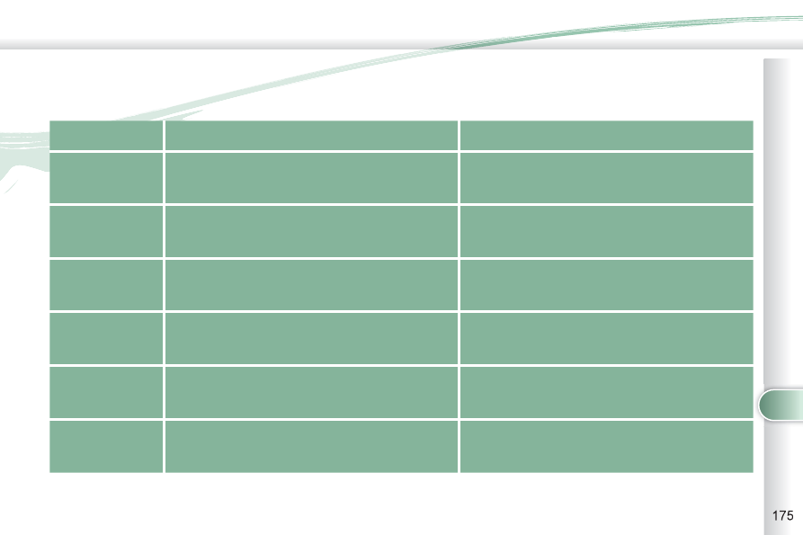
   TEXT   

   DESCRIPTION   

   SOLUTION   

  NO DISC  

 No disc present.  
Disc not compatible. 

 Insert a disc. 

  ERROR 01  

 Disc inserted incorrectly.  
Disc with condensation. 

 Insert the disc with the printed face upwards.  
Clean the dampness off the disc. 

  ERROR 02  

 Disc dirty, scratched or distorted.  
Excessive vehicle vibration. 

 Clean or replace the disc.  
Try again when the vibration has stopped. 

  ERROR 03  

 Error on insertion or ejection.  
Playing head misaligned. 

 Eject the disc and insert it again. If it is not ejected, 

have the audio equipment checked. 

  ERROR HOT  

 Triggering of the internal protection against high 

temperatures. 

 Wait approximately 30 minutes to allow the audio 

system to cool. 

  ERROR  

 Communication error between the audio system 

and the external system.  
External system supply error. 

 Consult a PEUGEOT dealer. 

11

AUDIO EQUIPMENT and TELEMATICS

  AUDIO: selection of Audio-video 

(FM, CD, music server, 

...) or 

Navigation (map) display.  

  VOL: adjustment of audio-video 

volume.  

  OPEN: tilts the 

screen and permits 

access to the CD/

DVD. A second press 

closes the screen.  

  SCALE: changing the scale of the 

map.  

  ENT: confi rms the choice of the 

item selected on the screen. 
 For certain operations, confi rma-

tion is given by contact with the 

touch screen.  

  Scrolling the map displayed or 

selection of an item.  

  For safety reasons, the driver 

must only carry out opera-

tions which require prolonged 

attention with the vehicle sta-

tionary.   

AUDIO-TELEMATIC SYSTEM

AUDIO-TELEMATIC SYSTEM

  Changing the audio-video source 

(FM, CD, music server, ...).  

  Mute on/off. 
 Next or previous selection for: 
   -  

a radio station, 

  -  

an audio track (CD), 

  -  

a chapter (DVD).   

 Move a fi nger over the screen to operate 

the system. 
 Use the buttons offered on the screen. 

  POWER: audio system on/off 

(only).  

  Setting the audio volume.  

11

AUDIO EQUIPMENT and TELEMATICS

DESCRIPTION OF THE CONTROLS - MENUS 

US 

  MODE:  Audio-video  menu for: 
   -  radio, 
  -  

audio, MP3 or WMA CD, 

  -  music 

server, 

  -  DVD. 


 MENU:  

Navigation-guidance  menu 

for selecting: 
   -  a 

destination, 

  -  

a point of interest (POI), 

  -  

an advanced search by POI, 

  -  

one of the 20 previous destinations, 

  -  

an address stored in the address 

book, 

  -  

the return home, 

  -  

certain navigation settings, 

  -  

a route demonstration.  

 NAVI: display of the current location 

on the  map .  

 SET:  Settings  menu for: 
   -  

switching off the screen, 

  -  

selecting the sound setting, 

  -  

selecting the picture quality, 

  -  

selecting the language, the time 

zone or the units, 

  -   selecting the size of the DVD 

picture, 

  -   selecting the guidance voice, 

the screen colour schemes or 

display of the audio-video icon, 

  -  

setting certain equipment available 

in your vehicle.  

 INFO:  

Information  menu for the 

consultation or adjustment of certain 

settings for your vehicle. 

11

AUDIO EQUIPMENT and TELEMATICS

NAVIGATION - GUIDANCE

NAVIGATION - GUIDANCE

  What is the navigation system and 

the GPS? 
 The satellite navigation system guides 

the driver to the destination that he has 

set in accordance with a chosen route. 
 Initially, it searches for the destination 

required by the user, then it calculates 

the route and fi nally it provides the visual 

and audible guidance instructions. 

  What precautions should be 

observed in order to make best use 

of the system? 
 Do not place anything on or near the 

GPS aerial. 
 Do not use any digital communication 

equipment (personal computers, etc.) 

near the GPS aerial. 
 Do not affi x any refl ective fi lms or fi lms 

containing carbon to the windows. 

 The GPS (Global Positioning 

System) consists of several 

satellites distributed around 

the earth. They continuously 

transmit digital signals which 

travel at the speed of light, on 2 different 

frequencies. 
 At any given time, the system receives 

its position in relation to the satellites 

detected and the time of transmission 

of the signal. 
 This enables the telematic unit to cal-

culate its position and therefore that of 

the vehicle. 
 A repositioning process using the map 

database stored on the hard disk allows 

the vehicle to be positioned on the road 

network, so improving the accuracy of 

the vehicle location function.  

  What is a point of interest (POI)? 

 Up to 40 different icons may 

be displayed (refer to the 

section "Points of interest 

icon"). 

 They are classifi ed in 5 groups and 

identifi ed by one colour for each group: 
   -  Shops, fi 

nance and businesses 

(Green), 

  -  

Vehicles and travel (Dark blue), 

  -  Restaurants 

(Orange), 

  -  

Public places and emergency services 

(Brown), 

  -  

Entertainment and attractions (Blue).    

  GPS 

 The system's measurements may be 

inaccurate if the vehicle is: 
   -  

in a tunnel or underground car park, 

  -  

underneath a two-level motorway, 

  -   in an area with several very high 

buildings, 

  -  

surrounded by closely planted trees.  

 Depending on the vehicle's situation and 

the reception of the GPS information, the 

displayed information may disappear from 

the screen temporarily.  

 A point of interest (POI) is 

represented by an icon on 

the map, it represents an 

airport, a station, a town 

hall, ... 

11

AUDIO EQUIPMENT and TELEMATICS

   A.   Manoeuvre icon: indicates whether 

the driver should turn left or right at 

the next junction indicated by the 

guidance and the distance to this 

junction. 

  B.   Guidance route: indicates the route 

to the destination. 

  C.   Vehicle marker: indicates the position 

of the vehicle while driving. 

  D.  TMC icon: displays traffi c  infor-

mation such as traffi c jams, road 

works, etc.  


When the icon is touched, detailed 

TMC information can be viewed. 

  E.   Orientation mark: indicates the ori-

entation of the map displayed. 

  F.   Map scale: indicates the scale of 

the map displayed. 

  G.  Name of the street: indicates the 

name of the current street. 

  H.  

Direction frame: displays the 

number of the next road or the 

name of the next street which the 

driver should turn into. 

  I.  Destination/intermediate destina-

tion icon: indicates the direction 

of the destination or intermediate 

destination. 

 Two-map display. 

 Single map display. 

                Information displayed on 

the map during navigation 

  J.  Destination/intermediate destination 

information: indicates the distance 

and the time remaining until the des-

tination or intermediate destination is 

reached. 

  K.   Press for  access  to the  Route

Menu  in order to:   

K1 - change the route in favour of an-

other making a detour through a

specifi ed region,   

K2 - change the position of the des-

tination, add an intermediate

destination and change the route

calculation conditions,   

K3 

display a route by various methods,   

-  delete a route created,   

K4 

-  search for points of interest (POI)

K5 

around the current location.   

K1

K2

K3

K4

K5

K

H

E

F

B

C

A

D

G

I

J

11

AUDIO EQUIPMENT and TELEMATICS

 B - 


 Select a location using the name of a 

point of interest (POI).   


Select: 

 B1  -  the country, 
 B2 - the city, 
 B3  -  the name of a stored POI, 
 B4 -   

a POI category (airport, bowling alley, 

bus station, car park, service station, 

hotel, cinema, ...), 

 B5  -  a detailed POI list. 

 C   - Select a location using an advanced 

search based on a POI: 

 C1  -  around the current location, 
 C2  -  on the current route, 
 C3  -  in the vicinity of the destination, 
 C4  -  on a chosen street, 
 C5  -  along a motorway or in the vicinity of the 

exit, 

 C6  -  by scrolling the map, 
 C7  -  taking the point of departure of the current 

route, 

 C8  -  specifying the latitude/longitude coordinates.  

 A - 


Select a location using the address or 

street name of the destination. Select: 

 A1 - the country, 
 A2 - the city, 
 A3 - the street, 
 A4  -  the house number, 
 A5  -  the name of a junction, 
 A6 -  

to select the search using either a number 

or a junction. 

 You have a maximum of 100 points of interest (POI) within a radius of 

approximately 60 miles (100 km). 

                Searching for a destination 

using an address or points of 

interest (POI) 

C3

C6

A

B

C

A4

A3

A2

A1

A6

A5

B1

B2

B3

B4

B5

C1

C2

C4

C5

C7

C8

11

AUDIO EQUIPMENT and TELEMATICS

  Searching using previous destinations, a stored address or a return home 

 E  -  Select a location using an address 

stored in the address book. Sort 

by: 

 E1  -  con, 
 E2  -  Name, 
 E3  -  Date. 

 D  - Select a location using one of the 

20 previous destinations. 

 F   -  Select a return home directly.   
 

  Press YES to store your home address 

(the first time).  

E2

E1

E3

D

E

F

11

AUDIO EQUIPMENT and TELEMATICS

  Navigation settings and 

information (1/2) 

 G  - Select the settings of functions 

linked with the navigation to: 

 G1  -  set the screen display parameters 

such as:   


-  display 1 or 2 maps,   


-  display or do not display the POIs 

on the map, display selected 

icons,   


-  change the colours of the map,   


-  display or do not display the name 

of the current street.   


-  display or do not display the address 

of the current street. 

 G2  -  set route conditions, such as, 
 

   -  avoiding traffi c problems, 


  -   avoiding selected areas, 


  -   avoiding roads at a certain time.  

 G3  -  set the route guidance mode and 

the displaying of the results of the 

route search. 

 G4  -  save, change or delete a location 

in the address book. 

 G5  -  display and select the traffi c infor-

mation such as traffi c jams or road 

works by selecting dynamic guidance.  

G1

G2

G3

G4

G5

G

11

AUDIO EQUIPMENT and TELEMATICS

 H  - Select basic information relating 

to the navigation as well as a pre-

set route demonstration to: 

 H1  

-  

choose to divert your route to 

avoid certain areas, 

 H2  

-  

select a location using an ad-

vanced search based on a POI 

along a motorway or in the vicinity 

of the motorway exit, 

 H3  -  start/stop the demonstration, 
 H4  -  recall a stored map screen.  

  Navigation settings and 

information (2/2) 

H1

H2

H3

H4

H

11

AUDIO EQUIPMENT and TELEMATICS

                         Selecting points of interest (POI) 

icons displayed on the map 

 You can select up to 40 types of point 

of interest icon which are displayed on 

your map screen. 
 Press the MENU button then [Navigation/

Settings]. 

 Press [Screen] then [Select] on the POI 

line. 
 Press [4] which is displayed. 

 Press each POI required. 
 At each contact with a POI, the display 

of [α] changes (α = the POI will be dis-

played on the screen). 

 General 

 Town centre 
 Locality 

 Shops, fi nance and businesses 

(Green) 

 Major companies 
 Shopping centre 

 Vehicles and travel 

(Dark blue) 

  PEUGEOT  
 Airport 
 Bus stop 
 Vehicle hire 
 Suburban station/station 
 Ferry terminal 
 Hotel 
 Park and ride 
 Car park (press +) 
 Service station 
 Rest area 
 Toll booth 
 Tourist information 
 Railway station 

 Restaurant (Orange) 

 Night life/night club 
 Restaurant 

 Public places and emergency 

services (Brown) 

 Town Hall 

 Community centre 

 Convention/exhibition centre 

 Hospital 
 University/college 

 Entertainment and attractions 

(Blue) 

 Theme park 
 Bowling alley 
 Casino 
 Cinema 
 Golf course 
 Historical monument 
 Skating rink 
 Marina 
 Museum 
 Flying club 
 Leisure area 
 Ski station 
 Sports centre 
 Theatre/opera 
 Tourist attraction 
 Vineyard/wine and spirit store 


11

AUDIO EQUIPMENT and TELEMATICS

 Press 

 Explanations 

 Result 

 Press the MENU button. 

 Press [Address/Junction]. 

 Press [Country] and enter the name of the country using the touch keypad. 
 When a character of the name of the country is entered, if 5 countries or 

fewer are recognised, you can select a country from a list which is dis-

played or press [List]. 

 You can select one of the 5 most recently selected countries by 

pressing [Last 5] on the "Country" line. 

 Press [City] then [Keyword] and enter the name of the city using the touch 

keypad. 
 When a character of the name of the city is entered, if 5 cities or fewer are 

recognised, you can select a city from a list which is displayed or press 

[List]. 

 You can select a city using the post code. 
 Press [Post Code] and enter the number. 

 You can select one of the 5 most recently selected cities by pressing 

[Last 5] on the "City" line.  

  Entering an address and starting guidance (1/2) 

11

AUDIO EQUIPMENT and TELEMATICS

  Entering an address and starting guidance (2/2) 

 Press 

 Explanations 

 Result 

 Press [Street] and enter the name of a street using the touch keypad. 
 When a character of the name of the street is entered, if 5 streets or fewer 

are recognised, you can select a street from a list which is displayed or 

press [List]. 

 Press [House #] and enter the number of the house using the touch keypad. 

 You can enter the name of a junction instead of the number 

of the street. Press [Junction] and select the name from a 

list which is displayed. 

 This is the result once all of the information has been entered: 

 If you agree with the information press [Set], otherwise press one of the 

buttons to correct. 

 Press [Start] to start the navigation.  

/

11

AUDIO EQUIPMENT and TELEMATICS

 Press 

 Explanations 

 Result 

 Press [Route]. 

 Press [Display new route].  
The system offers a detour route (dynamic guidance). 

 Press [Back] and enter to return to the previous screen.  
The system asks you to confi rm or not the new route. 

 Press [Yes] to confi rm your choice. The system displays the name of the 

new route.   
Press [No] to not register the route.  

  Traffic information 

 During navigation, the system gives you 

traffi c information received in real time. 
 The system can then suggest a detour 

route, if dynamic guidance has been 

activated by pressing MENU, [Naviga-

tion settings] then [TMC]. 

11

AUDIO EQUIPMENT and TELEMATICS

AUDIO-VIDEO 

AUDIO-VIDEO 

  What is RDS? 

  RDS station following 

  Traffi c information function 

 Your radio automatically checks 

and selects the best frequency 

for the radio station to which it is 

tuned (if the station broadcasts on se-

veral transmitters or frequencies). 
 The frequency of a radio station covers ap-

proximately 30 miles (50 km). The change 

from one frequency to another explains 

the loss of reception during a journey. 
 If the station to which you are listening 

does not have several frequencies in 

the region in which you are currently 

located, you can deactivate the auto-

matic frequency following.  

  Radio, RDS, AF, REG, TP, PTY 

 Radio Data System (RDS) function 

on the FM waveband permits: 

   -   tuning to the same station while 

travelling through different regions 

(if the transmitters of this station 

cover the area through which you 

are travelling), 

  -  

temporary tuning to traffi c information 

announcements, 

  -   display of the name of the station, 

etc...  

 Most FM stations use RDS. 
 These stations transmit non-audible 

data in addition to their programmes. 
 The data transmitted in this way allows 

you access to various functions, mainly 

displaying of the name of the station, 

temporary tuning to traffi c  information 

announcements or automatic station 

following. 
 RDS allows you to continue listening to 

the same station by means of the fre-

quency following. However, in certain 

conditions, this RDS frequency follo-

wing cannot be provided throughout 

the country. Radio stations do not cover 

the whole country, which explains the 

loss of reception of the station during 

a journey.  

 The Traffic Program (TP) func-

tion permits automatic and 

temporary switching to an FM 

station broadcasting traffi c information. 
 The radio station or the source that you 

are listening to at this point is paused. 
 Once the traffi c information has ended, 

the system switches back to the radio 

station or the source that you were lis-

tening to initially.  

  Regional following mode 

 Some stations are organised in 

a network. 
 In different regions, they broad-

cast different or shared programmes de-

pending on the time of day. 
 You can follow: 
   -  

a regional station only, 

  -  

the entire network, with the possibility 

that you will be listening to a different 

programme.   

  Programme types 

 Some stations offer the option of 

listening to a themed type of pro-

gramme as a priority, selected from 

the list available below: 
 NEWS, AFFAIRS, INFOS, SPORT, 

EDUCATE, DRAMA, CULTURE, SCIENCE, 

VARIED, POP M, ROCK M, EASY M,

LIGHT M, CLASSICS, OTHER M, 

WEATHER, FINANCE, CHILDREN,

SOCIAL, RELIGION, PHONE IN, TRAVEL, 

LEISURE, JAZZ, COUNTRY, NATION M,

OLDIES, FOLK M, DOCUMENT.   

11

AUDIO EQUIPMENT and TELEMATICS

                Information displayed in Radio mode 

   A.   A pre-set number is displayed when a 

pre-set channel has been selected. 

  B.   The name of the station is displayed 

during the reception of RDS data. If 

the name has not been transmitted, 

the frequency is displayed. 

  C.   Stereo is displayed when a stereo 

transmission is received. 

  D.   AF is displayed when the AF control 

function is activated. 

  E.   PTY (programme type) is displayed 

if the RDS data received is dis-

played.  


TRAFINF is displayed, during an in-

terruption, for traffi c information.  


ALARM is displayed, during an in-

terruption, for urgent information. 

  F.   Display of 6 pre-set stored stations. 

  G.   To receive the stored station.  
 

Press and hold to store a station. 

  H.  To change the frequency step by 

step.  


Press and hold for scrolling of the 

frequency. 

  I.   To search for currently broadcast-

ing stations which can be received 

in the current location, until a station 

is found. 

  J.  To display the programme types 

pre-setting screen, e.g.: sport, rock, 

classical, news, ... Press PTY again 

to exit. 

  K.   Press this button to display the sec-

ondary menu. 

  L.   REG is displayed during the reception 

of regional frequencies data. 

  M.   RDS is displayed during the reception 

of RDS data. 

  N.   TP is displayed when the traffi c infor-

mation is in standby mode.   

A

B

C

D

E

G

H

I

J

K

L

M

N

F

11

AUDIO EQUIPMENT and TELEMATICS

  Radio, selecting an FM station and storing 

 Press the MODE button. 

 Press  

Explanations  

Result 

     You can select [    Seek] or [Seek    ] to start a continuous 

search until the stations which can be received in the current 

location are detected. 

 Press FM. By default the screen shows the FM1 stations. 

   Press [    Tune] to decrease the frequency or [Tune 

  ] to increase the 

frequency. The frequency is changed in steps of 0.1 MHz. 
 Continue to press to tune to a station automatically. 

 Once the frequency has been selected, a long press on the station (e.g. 3) 

will store it. 
 The name of the station (e.g. PS name 1) is displayed if it is available. 

 You can start automatic storing on FM3 for 6 stations, which 

can be received in the current location, by pressing [^] then 

[Auto-Store].  

 You can also start a search by type of programme by pressing 

[PTY]. 


Content   ..  10  11  12  13   ..