JEPPESEN GENERAL AIRWAY MANUAL (Issue Date 1 JUL 21) - page 22
 

  Index      Manuals     JEPPESEN GENERAL AIRWAY MANUAL (Issue Date 1 JUL 21)


Search            copyright infringement  


Content      ..     20      21      22      23     ..


JEPPESEN GENERAL AIRWAY MANUAL (Issue Date 1 JUL 21) - page 22


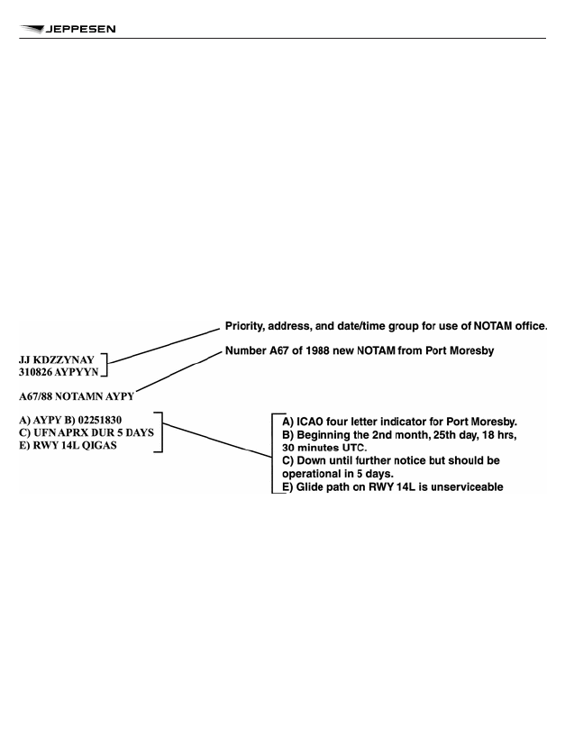
C)  

Ten figure date-time group or PERM indicating the duration of the NOTAM. If the dura-
tion of the NOTAM is uncertain, the approximate duration must be indicated using the
date-time group followed by EST.

D)  

Specified periods for changes being reported, otherwise omitted.

E)


Decoded NOTAM code in plain language. ICAO abbreviations may be used where ap-
propriate.

F)

}

These items are normally applicable to navigational warnings or airspace restrictions
clearly indicating reference datum and units of measurement. Item F provides the low-
er limit and item G provides the upper limit.

G)

SOME STATES ARE STILL PROMULGATING CLASS I NOTAMS IN THE PREVIOUS
FORMAT.

PREVIOUS NOTAM FORMAT AND EXPLANATION

A)


ICAO location indicator of aerodrome or FIR.

B)


Eight figure date-time group, WIE (with immediate effect), or WEF (with effect from) in-
dicating when the NOTAM comes into force.

C)  

Eight figure date-time group, PERM, or UFN (until further notice) indicating the dura-
tion of the NOTAM. If the duration of the NOTAM is UFN, the approximate duration of
the information should also be indicated.

D)  

Specified periods for changes being reported, otherwise omitted.

E)


NOTAM code, abbreviated plain language or both.

F)

}

These items are normally applicable to navigational warnings or airspace restrictions
clearly indicating reference datum and units of measurement.

G)

NOTAM REFERENCE INFORMATION

673

NOTAMS

NOTAM CODE

SECOND AND THIRD LETTERS

SECOND AND THIRD LETTERS (Q__ __)

CODE

SIGNIFICATION

UNIFORM ABBREVIATED

PHRASEOLOGY

AGA
Lighting facilities (L)

LA

Approach light system (specify runway and type)

als

LB

Aerodrome beacon

abn

LC

Runway centerline lights (specify runway)

rcll

LD

Landing direction indicator lights

ldi lgt

LE

Runway edge lights (specify runway)

redl

LF

Sequenced flashing lights (specify runway)

sequenced flg lgt

LG

Pilot-controlled lighting

pcl

LH

High intensity runway lights (specify runway)

high intst rwy lgt

LI

Runway end identifier lights (specify runway)

rwy end id lgt

LJ

Runway alignment indicator lights (specify runway)

rai lgt

LK

Category II components of approach lighting system
(specify runway)

cat II components als

LL

Low intensity runway lights (specify runway)

low intst rwy lgt

LM

Medium intensity runway lights (specify runway)

medium intst rwy lgt

LP

Precision approach path indicator (PAPI) (specify run-
way)

papi

LR

All landing area lighting facilities

ldg area lgt fac

LS

Stopway lights (specify runway)

stwl

LT

Threshold lights (specify runway)

thr lgt

LU

Helicopter approach path indicator

hapi

LV

Visual approach slope indicator system (specify type
and runway)

vasis

LW

Heliport lighting

heliport lgt

LX

Taxiway centerline lights (specify taxiway)

twy cl lgt

LY

Taxiway edge lights (specify taxiway)

twy edge lgt

NOTAM REFERENCE INFORMATION

674

NOTAMS

SECOND AND THIRD LETTERS (Q__ __)

CODE

SIGNIFICATION

UNIFORM ABBREVIATED

PHRASEOLOGY

LZ

Runway touchdown zone lights (specify runway)

rtzl

AGA
Movement and landing area (M)

MA

Movement area

mov area

MB

Bearing strength (specify part of landing area or move-
ment area)

bearing strength

MC

Clearway (specify runway)

cwy

MD

Declared distances (specify runway)

declared dist

MG

Taxiing guidance system

tgs

MH

Runway arresting gear (specify runway)

rag

MK

Parking area

prkg area

MM

Daylight markings (specify threshold, centerline, etc.)

day markings

MN

Apron

apron

MO

Stopbar (specify taxiway)

stopbar

MP

Aircraft stands (specify)

acft stand

MR

Runway (specify runway)

rwy

MS

Stopway (specify runway)

swy

MT

Threshold (specify runway)

thr

MU

Runway turning bay (specify runway)

rwy turning bay

MW

Strip/shoulder (specify runway)

strip/shoulder

MX

Taxiway(s) (specify)

twy

MY

Rapid exit taxiway (specify)

rapid exit twy

AGA
Facilities and services (F)

FA

Aerodrome

ad

FB

Friction Measuring Device (specify type)

friction measuring device

FC

Ceiling measurement equipment

ceiling measurement eqpt

FD

Docking system (specify AGNIS, BOLDS, etc.)

dckg system

NOTAM REFERENCE INFORMATION

675

NOTAMS

SECOND AND THIRD LETTERS (Q__ __)

CODE

SIGNIFICATION

UNIFORM ABBREVIATED

PHRASEOLOGY

FE

Oxygen (specify type)

oxygen

FF

Fire fighting and rescue

fire and rescue

FG

Ground movement control

gnd mov ctl

FH

Helicopter alighting area/platform

hel alighting area

FI

Aircraft de-icing(specify)

acft de-ice

FJ

Oils (specify type)

oil

FL

Landing direction indicator

ldi

FM

Meteorological service (specify type)

met

FO

Fog dispersal system

fg dispersal

FP

Heliport

heliport

FS

Snow removal equipment

sn removal eqpt

FT

Transmissometer (specify runway and, where applica-
ble, designator(s) of transmissometer(s))

transmissometer

FU

Fuel availability

fuel avbl

FW

Wind direction indicator

wdi

FZ

Customs

cust

ATM
Airspace organization (A)

AA

Minimum altitude (specify enroute/crossing/safe)

mnm alt

AC

Control zone (CTR)

ctr

AD

Air defense identification zone (ADIZ)

adiz

AE

Control area (CTA)

cta

AF

Flight information region

fir

AH

Upper control area

uta

AL

Minimum usable flight level

mnm usable fl

AN

Area navigation route

rnav route

AO

Oceanic control area

oca

AP

Reporting point (specify name or coded designator)

rep

NOTAM REFERENCE INFORMATION

676

NOTAMS

SECOND AND THIRD LETTERS (Q__ __)

CODE

SIGNIFICATION

UNIFORM ABBREVIATED

PHRASEOLOGY

AR

ATS route (specify)

ats rte

AT

Terminal control area (TMA)

tma

AU

Upper flight information region (UIR)

uir

AV

Upper advisory area (UDA)

uda

AX

Significant point

sig

AZ

Aerodrome traffic zone

atz

ATM
Air traffic and VOLMET services (S)

SA

Automatic terminal information service (ATIS)

atis

SB

ATS reporting office

aro

SC

Area control center

acc

SE

Flight information service

fis

SF

Aerodrome flight information service

afis

SL

Flow control center

flow ctl center

SO

Oceanic area control center

oac

SP

Approach control service

app

SS

Flight service station

fss

ST

Aerodrome control tower

twr

SU

Upper area control center

uac

SV

VOLMET Broadcast

volmet

SY

Upper advisory service (specify)

upper advisory ser

ATM
Air traffic procedures (P)

PA

Standard instrument arrival (specify route designator)

star

PB

Standard VFR arrival

std vfr arr

PC

Contingency procedure

contingency proc

PD

Standard instrument departure (specify route designa-
tor)

sid

NOTAM REFERENCE INFORMATION

677

NOTAMS

SECOND AND THIRD LETTERS (Q__ __)

CODE

SIGNIFICATION

UNIFORM ABBREVIATED

PHRASEOLOGY

PE

Standard VFR department

std vfr dep

PF

Flow control procedure

flow ctl proc

PH

Holding procedure

hldg proc

PI

Instrument approach procedure (specify type and run-
way)

inst apch proc

PK

VFR approach procedure

vfr apch proc

PL

Flight plan processing, filing and related contingency

fpl

PM

Aerodrome operating minima (specify procedure and
amended minimum)

opr minima

PN

Noise operating restrictions

noise opr restrictions

PO

Obstacle clearance altitude and height (specify proce-
dure)

oca och

PR

Radio failure procedure

rdo failure proc

PT

Transition altitude or transition level (specify)

ta/trl

PU

Missed approach procedure (specify runway)

missed apch proc

PX

Minimum holding altitude (specify fix)

mnm hldg alt

PZ

ADIZ procedure

adiz proc

CNS
Communication and surveillance facilities (C)

CA

Air/ground facility (specify service and frequency)

a/g fac

CB

Automatic dependent surveillance – broadcast (details)

ads-b

CC

Automatic dependent surveillance – contract (details)

ads-c

CD

Controller-pilot datalink communications (details)

cpdlc

CE

Enroute surveillance radar

rsr

CG

Ground controlled approach system

gca

CL

Selective calling system

selcal

CM

Surface movement radar

smr

CP

Precision approach radar (specify runway)

par

NOTAM REFERENCE INFORMATION

678

NOTAMS

SECOND AND THIRD LETTERS (Q__ __)

CODE

SIGNIFICATION

UNIFORM ABBREVIATED

PHRASEOLOGY

CR

Surveillance radar element of precision approach radar
system (specify wavelength)

sre

CS

Secondary surveillance radar

ssr

CT

Terminal area surveillance radar

tar

CNS
Instrument and microwave landing systems (I)

IC

Instrument landing system (specify runway)

ils

ID

DME associated with ILS

ils dme

IG

Glide path (ILS) (specify runway)

ils gp

II

Inner marker (ILS) (specify runway)

ils im

IL

Localizer (ILS) (specify runway)

ils llz

IM

Middle marker (ILS)(specify runway)

ils mm

IN

Localizer (not associated with ILS)

llz

IO

Outer marker (ILS) (specify runway)

ils om

IS

ILS Category I (specify runway)

ils cat I

IT

ILS Category II (specify runway)

ils cat II

IU

ILS Category III (specify runway)

ils cat III

IW

Microwave landing system (specify runway)

mls

IX

Locator, outer (ILS) (specify runway)

ils lo

IY

Locator, middle (ILS) (specify runway)

ils lm

CNS
GNSS services (G)

GA

GNSS airfield-specific operations (specify operation)

gnss airfield

GW

GNSS area-wide operations (specify operation)

gnss area

CNS
Terminal and enroute navigation facilities (N)

NA

All radio navigation facilities (except. . .)

all rdo nav fac

NB

Non-directional radio beacon

ndb

NOTAM REFERENCE INFORMATION

679

NOTAMS

SECOND AND THIRD LETTERS (Q__ __)

CODE

SIGNIFICATION

UNIFORM ABBREVIATED

PHRASEOLOGY

NC

DECCA

decca

ND

Distance measuring equipment

dme

NF

Fan marker

fan mkr

NL

Locator (specify identification)

l

NM

VOR/DME

vor/dme

NN

TACAN

tacan

NO

OMEGA

omega

NT

VORTAC

vortac

NV

VOR

vor

NX

Direction finding station (specify type and frequency)

df

Navigation warnings
Airspace restrictions (R)

RA

Airspace reservation (specify)

airspace reservation

RD

Danger area (specify)

. . d . .

RM

Military operating area

moa

RO

Overflying of . . . (specify)

overflying

RP

Prohibited area (specify)

. . p . .

RR

Restricted area

. . r . .

RT

Temporary restricted area (specify area)

tempo restricted area

Navigation warnings
Warnings (W)

WA

Air display

air display

WB

Aerobatics

aerobatics

WC

Captive balloon or kite

captive balloon/kite

WD

Demolition of explosives

demolition of explosives

WE

Exercises (specify)

exer

WF

Air refuelling

air refuelling

WG

Glider flying

gld fly

NOTAM REFERENCE INFORMATION

680

NOTAMS

SECOND AND THIRD LETTERS (Q__ __)

CODE

SIGNIFICATION

UNIFORM ABBREVIATED

PHRASEOLOGY

WH

Blasting

blasting

WJ

Banner/target towing

banner/target towing

WL

Ascent of free balloon

ascent of free balloon

WM

Missile, gun or rocket firing

missile/gun/rocket frng

WP

Parachute jumping exercise, paragliding or hang gliding pje/paragliding/hang gliding

WR

Radioactive materials or toxic chemicals (specify)

radioactive materials/toxic
chemicals

WS

Burning or blowing gas

burning/blowing gas

WT

Mass movement of aircraft

mass mov of acft

WU

Unmanned aircraft

ua

WV

Formation flight

formation flt

WW

Significant volcanic activity

significant volcanic act

WY

Aerial survey

aerial survey

WZ

Model flying

model fly

Other information (O)

OA

Aeronautical information service

ais

OB

Obstacle (specify details)

obst

OE

Aircraft entry requirements

acft entry rqmnts

OL

Obstacle lights on . . . (specify)

obst lgt

OR

Rescue co-ordination center

rcc

FOURTH AND FIFTH LETTERS

FOURTH AND FIFTH LETTERS

CODE

SIGNIFICATION

UNIFORM ABBREVIATED

PHRASEOLOGY

Availability (A)

AC

Withdrawn for maintenance

withdrawn maint

AD

Available for daylight operation

avbl day ops

AF

Flight checked and found reliable

fltck okay

NOTAM REFERENCE INFORMATION

681

NOTAMS

FOURTH AND FIFTH LETTERS

CODE

SIGNIFICATION

UNIFORM ABBREVIATED

PHRASEOLOGY

AG

Operating but ground checked only, awaiting flight
check

opr but gnd ck only, awaiting flt ck

AH

Hours of service are now . . . (specify)

hr ser

AK

Resumed normal operation

okay

AL

Operative (or reoperative) subject to previously
published limitations/conditions

opr subj previous cond

AM

Military operations only

mil ops only

AN

Available for night operation

avbl ngt ops

AO

Operational

opr

AP

Available, prior permission required

avbl ppr

AR

Available on request

avbl o/r

AS

Unserviceable

u/s

AU

Not available (specify reason if appropriate)

not avbl

AW

Completely withdrawn

withdrawn

AX

Previously promulgated shutdown has been can-
celled

promulgated shutdown cnl

Changes (C)

CA

Activated

act

CC

Completed

cmpl

CD

Deactivated

deactivated

CE

Erected

erected

CF

Operating frequency(ies) changed to

opr freq changed to

CG

Downgraded to

downgraded to

CH

Changed

changed

CI

Identification or radio call sign changed to

ident/rdo call sign changed to

CL

Realigned

realigned

CM

Displaced

displaced

CN

Cancelled

cnl

CO

Operating

opr

NOTAM REFERENCE INFORMATION

682

NOTAMS

FOURTH AND FIFTH LETTERS

CODE

SIGNIFICATION

UNIFORM ABBREVIATED

PHRASEOLOGY

CP

Operating on reduced power

opr reduced pwr

CR

Temporarily replaced by

tempo rplcd by

CS

Installed

instl

CT

On test, do not use

on test, do not use

Hazard conditions (H)

HA

Braking action is. . .

a. Poor
b. Medium/Poor

c. Poor

d. Medium/Good
e. Good

ba is . . .

HB

Friction coefficient is. . . (specify friction measuring
device used)

friction coefficient is

HC

Covered by compacted snow to a depth of

cov compacted sn depth

HD

Covered by dry snow to a depth of

cov dry sn depth

HE

Covered by water to a depth of

cov water depth

HF

Totally free of snow and ice

free of sn and ice

HG

Grass cutting in progress

grass cutting inpr

HH

Hazard due to (specify)

hazard due

HI

Covered by ice

cov ice

HJ

Launch planned. . .(specify balloon flight identifica-
tion or project code name, launch site, planned pe-
riod of launch(es) - date/time, expected climb direc-
tion, estimated time to pass 18,000m (60,000 ft), or
reaching cruise level if at or below 18,000m
(60,000 ft), together with estimated location)

launch plan

HK

Bird migration in progress (specify direction)

bird migration inpr

HL

Snow clearance completed

snow clr cmpl

HM

Marked by

marked by

HN

Covered by wet snow or slush to a depth of

cov wet sn/slush depth

NOTAM REFERENCE INFORMATION

683

NOTAMS

FOURTH AND FIFTH LETTERS

CODE

SIGNIFICATION

UNIFORM ABBREVIATED

PHRASEOLOGY

HO

Obscured by snow

obscured by sn

HP

Snow clearance in progress

snow clr inpr

HQ

Operation cancelled. . .(specify balloon flight identi-
fication or project code name)

opr cnl

HR

Standing water

standing water

HS

Sanding in progress

sanding inpr

HT

Approach according to signal area only

apch according signal area only

HU

Launch in progress. . .(specify balloon flight identifi-
cation or project code name, launch site, date/time
of launch(es), estimated time passing 18,000m
(60,000 ft), or reaching cruising level if at or below
18,000m (60,000 ft), together with estimated loca-
tion, estimated date/time of termination of the flight
and planned location of ground contact, when ap-
plicable)

launch inpr

HV

Work completed

work cmpl

HW

Work in progress

wip

HX

Concentration of birds

bird concentration

HY

Snow banks exist (specify height)

sn banks hgt

HZ

Covered by frozen ruts and ridges

cov frozen ruts and ridges

Limitations (L)

LA

Operating on auxiliary power supply

opr aux pwr

LB

Reserved for aircraft based therein

reserved for acft based therein

LC

Closed

clsd

LD

Unsafe

unsafe

LE

Operating without auxiliary power supply

opr aux wo pwr

LF

Interference from

interference fm

LG

Operating without identification

opr wo ident

LH

Unserviceable for aircraft heavier than

u/s acft heavier than

LI

Closed to IFR operations

clsd ifr ops

LK

Operating a a fixed light

opr as f lgt. . .

NOTAM REFERENCE INFORMATION

684

NOTAMS

FOURTH AND FIFTH LETTERS

CODE

SIGNIFICATION

UNIFORM ABBREVIATED

PHRASEOLOGY

LL

Usable for length of. .and width of. .

usable len/wid. . .

LN

Closed to all night operations

clsed to all ngt ops

LP

Prohibited to

prohibited to

LR

Aircraft restricted to runways and taxiways

acft restricted to rwy and twy

LS

Subject to interruption

subj intrp

LT

Limited to

ltd to

LV

Closed to VFR operations

clsd vfr ops

LW

Will take place

will take place

LX

Operating but caution advised due to

opr but caution advised due to

Other (XX)

XX

Where 4th and 5th letter code does not cover the
situation use XX and supplement by plain language

(plain language following the NO-
TAM Code)

NOTAM REFERENCE INFORMATION

685

NOTAMS

Tables and Codes

SNOWTAM Reference Information

Extracted from ICAO Annex 15 — AERONAUTICAL INFORMATION SERVICES

ORIGINATION AND DISTRIBUTION

Notification of the presence or removal or significant changes in hazardous conditions due to
snow, slush, ice or water on the movement area is to be made preferably by use of the SNOW-
TAM format, or the NOTAM Code and plain language.
Information concerning snow, ice and standing water on aerodrome pavements shall, when repor-
ted by means of a SNOWTAM, contain information in the order shown in the following SNOW-
TAM Format.

SNOWTAM REFERENCE INFORMATION

687

SNOWTAM

SNOWTAM FORMAT

SNOWTAM REFERENCE INFORMATION

688

SNOWTAM

GUIDANCE FOR THE COMPLETION OF THE SNOWTAM FORMAT

GENERAL

a. When reporting on two or three runways, repeat Items B to P inclusive.
b. Items together with their indicator must be dropped completely, where no information is to be

included.

c. Metric units must be used and the unit of measurement not reported.

d. The maximum validity of SNOWTAM is 24 hours. New SNOWTAM must be issued whenever

there is a significant change in conditions. The following changes relating to runway condi-
tions are considered as significant:

1. a change in the coefficient of friction of about 0.05;
2. changes in depth of deposit greater than the following:

– 20mm for dry snow;
– 10mm for wet snow;
– 3mm for slush;

3. a change in the available length or width of a runway of 10 per cent or more;
4. any change in the type of deposit or extent of coverage which requires reclassification

in Items F or T of the SNOWTAM;

5. when critical snow banks exist on one or both sides of the runway, any change in the

height or distance from centerline;

6. any change in the conspicuity of runway lighting caused by obscuring of the lights;
7. any other conditions known to be significant according to experience or local circum-

stances.

e. The abbreviated heading “TTAAiiii CCCC MMYYGGgg (BBB)” is included to facilitate the

automatic processing of SNOWTAM messages in computer data banks. The explanation of
these symbols is:

TT =

data designator for SNOWTAM = SW;

AA =

geographical designator for States; e.g., LF = France, EG = Uni-
ted Kingdom;

iiii =

SNOWTAM serial number in a four-figure group;

CCCC =

four-letter location indicator of the aerodrome to which the
SNOWTAM refers;

MMYGGgg =

date/time of observation/measurement, whereby:

SNOWTAM REFERENCE INFORMATION

689

SNOWTAM

– MM =

month; e.g., January = 01, December = 12

– YY =

day of the month

– GGgg =

time in hours (GG) and minutes (gg) UTC;

(BBB) =

optional group for: correction to SNOWTAM message previously
disseminated with the same serial number = COR.

NOTE 1: Brackets in (BBB) are used to indicate that this group is optional.
NOTE 2: When reporting on more than one runway and individual dates/times of observa-
tion/measurement are indicated by repeated Item B, the latest date/time of observation/
measuring is inserted in the abbreviated heading (MMYYGGgg).
EXAMPLE: Abbreviated heading of SNOWTAM No. 149 from Zurich, measurement/observa-
tion of 7 November at 0620 UTC:

SWLS0149 LSZH 1107 0620

NOTE: The information groups are separated by a space, as illustrated above.

f. The text “SNOWTAM” in the SNOWTAM Format and the SNOWTAM serial number in a four-

digit group shall be separated by a space, for example: SNOWTAM 0124.

g. For readability purposes for the SNOWTAM message, include a line feed after the SNOW-

TAM serial number, after Item A, after the last item referring to the runway (e.g. Item P) and
after Item S.

Item A
Aerodrome location indicator (four-letter location indicator).

Item B
Eight-figure date/time group – giving time of observation as month, day, hour and minutes in
UTC; this item must always be completed.

Item C
Lower runway designator number.

Item D
Cleared runway length in meters, if less than published length (see Item T on reporting on part
of runway not cleared).

Item E

SNOWTAM REFERENCE INFORMATION

690

SNOWTAM

Cleared runway width in meters, if less than published width; if offset left or right of center line,
add (without space) “L” or “R”, as viewed from the threshold having the lower runway designa-
tion number.

Item F
Deposit over total runway length as explained in SNOWTAM Format. Suitable combinations of
these numbers may be used to indicate varying conditions over runway segments. If more than
one deposit is present on the same portion of the runway, they should be reported in sequence
from the top (closest to the sky) to the bottom (closest to the runway). Drifts, depths of deposit
appreciably greater than the average values or other significant characteristics of the deposits
may be reported under Item T in plain language. The values for each third of the runway shall
be separated by an oblique stroke (/), without space between the deposit values and the obli-
que stroke, for example: 47/47/47.
NOTE: Definitions for the various types of snow are given at the end of this Appendix.

Item G
Mean depth in millimeters deposit for each third of total runway length, or “XX” if not measura-
ble or operationally not significant; the assessment to be made to an accuracy of 20mm for dry
snow, 10mm for wet snow and 3mm for slush. The values for each third of the runway shall be
separated by an oblique stroke (/), without space between the values and the oblique stroke,
for example: 20/20/20.

Item H
Estimated surface friction on each third of the runway (single digit) in the order from the thresh-
old having the lower runway designation number.
Friction measurement devices can be used as part of the overall runway surface assessment.
Some States may have developed procedures for runway surface assessment which may
include the use of information obtained from friction measuring devices and the reporting of
quantitative values. In such cases, these procedures should be published in the AIP and the
reporting made in Item (T) of the SNOWTAM format.
The values for each third of the runway are separated by an oblique stroke (/), without space
between the values and the oblique stroke-, for example: 5/5/5.

Item J
Critical Snowbanks. If present insert height in centimeters and distance from edge of runway in
meters, followed (without space) by left (“L”) or right (“R”) side or both sides (“LR”), as viewed
from the threshold having the lower runway designation number.

Item K
If runway lights are obscured, insert “YES” followed (without space) by “L”, “R” or both “LR”, as
viewed from the threshold having the lower runway designation number.

Item L

SNOWTAM REFERENCE INFORMATION

691

SNOWTAM

When further clearance will be undertaken, enter length and width of runway or “TOTAL” if
runway will be cleared to full dimensions.

Item M
Enter the anticipated time of completion in UTC.

Item N
The code (and combination of codes) for Item F may be used to describe taxiway conditions;
enter “NO” if no taxiways serving the associated runway are available.

Item P
If snow banks are higher than 60 cm, enter “YES” followed by the lateral distance parting the
snow banks (the distance between) in meters.

Item R
The code (and combination of codes) for Item F may be used to describe apron conditions;
enter “NO” if apron unusable.

Item S
Enter the anticipated time of next observation/measurement in UTC.

Item T
Describe in plain language any operationally significant information but always report on length
of uncleared runway (Item D) and extent of runway contamination (Item F) for each third of the
runway (if appropriate) in accordance with the following scale:
RWY CONTAMINATION 10% — if 10% or less of runway contaminated
RWY CONTAMINATION 25% — if 11-25% of runway contaminated
RWY CONTAMINATION 50% — if 26-50% of runway contaminated
RWY CONTAMINATION 100% — if 51-100% of runway contaminated.

EXAMPLE OF COMPLETED SNOWTAM FORMAT

GG EHAMZQZX EDDFZQZX EKCHZQZX
070645 LSZHYNYX
SWLS0149 LSZH 11070700
SNOWTAM 0149
A) LSZH


B) 11070620

C) 02

D) . . . P)

B) 11070600

C) 09

D) . . . P)

B) 11070700

C) 12

D) . . . P)

SNOWTAM REFERENCE INFORMATION

692

SNOWTAM

R) NO

S) 11070920


T) DEICING


NOTE: See the Aeronautical Information Services Manual (Doc 8126) (not published herein) for
additional SNOWTAM examples incorporating different runway conditions.

DEFINITIONS OF THE VARIOUS TYPES OF SNOW

SLUSH — Water-saturated snow which with a heel-and-toe slap-down motion against the ground
will be displaced with a splatter; specific gravity: 0.5 up to 0.8.
NOTE: Combinations of ice, snow and/or standing water may, especially when rain, rain and
snow, or snow is falling, produce substances with specific gravities in excess of 0.8. These sub-
stances, due to their high water/ice content, will have a transparent rather than a cloudy appear-
ance and, at the higher specific gravities, will be readily distinguishable from slush.
SNOW (on the ground) —

a.

Dry Snow: Snow which can be blown if loose or, if compacted by hand, will fall apart again
upon release; specific gravity: up to but not including 0.35.

b.

Wet Snow: Snow which, if compacted by hand, will stick together and tend to or form a
snowball; specific gravity: 0.35 up to but not including 0.5.

c.

Compacted Snow: Snow which has been compressed into a solid mass that resists further
compression and will hold together or break up into lumps if picked up; specific gravity: 0.5
and over.

SNOWTAM REFERENCE INFORMATION

693

SNOWTAM

Tables and Codes

Radio Frequency and Time

Information

General

In airspaces such as North Atlantic (NAT) minimum navigation performance specifications
(MNPS) airspace, the time reference system(s) to be used during the flight for calculation of way-
point estimated times of arrival (ETAs) and waypoint actual times of arrival (ATAs) shall be
synchronized to universal coordinated time (UTC). All ETAs and ATAs passed to air traffic control
shall be based on a time reference that has been synchronized to UTC or equivalent. Acceptable
sources of UTC include:
WWV – National Institute of Standards and Technology (Fort Collins, Colorado). WWV operates
24 hours a day on 2500, 5000, 10000, 15000, 20000 kHz (AM/single sideband (SSB)) and pro-
vides UTC voice every minute.
GPS (corrected to UTC) – Available 24 hours a day to those pilots who can access the time signal
over their shipboard GPS equipment.
CHU – National Research Council (NRC) – Available 24 hours a day on 3330, 7850, and 14670
kHz (SSB). In the final 10-second period of each minute, a bilingual station identification and time
announcement is made.
BBC – British Broadcasting Corporation (United Kingdom). The BBC transmits on a number of
domestic and worldwide frequencies and transmits the Greenwich time signal (referenced to
UTC) once every hour on most frequencies, although there are some exceptions.
Any other source shown to the State of Registry or State of Operator (as appropriate) to be an
equivalent source of UTC.

RADIO FREQUENCY AND TIME INFORMATION

695

STANDARD TIME SIGNALS

RADIO FREQUENCY AND TIME INFORMATION

696

STANDARD TIME SIGNALS

Tables and Codes

Sunrise and Sunset Tables

SUNRISE AND SUNSET TABLES

SUNRISE JANUARY UNTIL JUNE

LAT

Jan

Feb

Mar

Apr

May

Jun

01

16

03

15

02

14

01

16

01

16

03

15

77ºN  


1036 0809 0640 0430 0217  


75ºN  


0940 0751 0635 0443 0257  


65ºN 1007 0936 0842 0801 0707 0624 0517 0422 0327 0223 0133 0105
60ºN 0902 0847 0810 0739 0656 0621 0526 0441 0359 0321 0247 0236
58ºN 0846 0833 0800 0732 0653 0620 0529 0447 0408 0334 0305 0256
56ºN 0831 0820 0752 0726 0650 0619 0531 0453 0417 0346 0320 0313
54ºN 0819 0810 0744 0721 0647 0618 0534 0458 0424 0356 0333 0327
52ºN 0808 0801 0737 0716 0644 0617 0536 0502 0431 0405 0345 0339
50ºN 0759 0752 0731 0711 0642 0617 0537 0506 0437 0413 0355 0350
45ºN 0738 0734 0718 0701 0637 0615 0541 0514 0450 0430 0416 0413
40ºN 0722 0720 0707 0653 0632 0614 0545 0521 0500 0444 0433 0430
35ºN 0708 0708 0658 0646 0629 0613 0547 0527 0510 0456 0447 0445
30ºN 0656 0657 0649 0640 0625 0612 0550 0533 0517 0506 0459 0458
25ºN 0645 0649 0642 0635 0622 0611 0552 0537 0525 0515 0510 0510
20ºN 0635 0638 0635 0629 0619 0610 0554 0542 0531 0524 0520 0520
15ºN 0626 0630 0629 0625 0617 0609 0556 0546 0537 0531 0529 0530
10ºN 0617 0622 0622 0620 0614 0608 0557 0549 0543 0539 0538 0539
5ºN

0608 0614 0616 0615 0612 0607 0559 0553 0548 0546 0546 0548

0600 0606 0610 0611 0609 0606 0601 0557 0554 0553 0554 0557

5ºS

0552 0559 0604 0607 0606 0605 0602 0600 0600 0559 0603 0606

10ºS

0543 0551 0558 0602 0604 0604 0604 0604 0605 0607 0611 0614

15ºS

0534 0543 0552 0557 0601 0603 0605 0607 0611 0613 0620 0623

20ºS

0525 0534 0545 0552 0558 0602 0607 0611 0616 0621 0629 0632

25ºS

0514 0525 0538 0546 0555 0600 0609 0615 0623 0629 0639 0643

30ºS

0503 0515 0530 0540 0551 0559 0610 0619 0629 0632 0649 0654

35ºS

0450 0504 0522 0534 0548 0557 0613 0624 0637 0647 0701 0706

SUNRISE AND SUNSET TABLES

698

SUNRISE AND SUNSET TABLES

LAT

Jan

Feb

Mar

Apr

May

Jun

01

16

03

15

02

14

01

16

01

16

03

15

40ºS

0436 0451 0512 0526 0543 0556 0615 0629 0645 0659 0713 0720

45ºS

0418 0435 0500 0517 0538 0553 0618 0636 0655 0711 0730 0737

50ºS

0356 0416 0445 0506 0532 0551 0621 0643 0707 0727 0750 0758

55ºS

0327 0351 0427 0452 0524 0548 0624 0652 0721 0746 0815 0825

60ºS

0244 0315 0402 0434 0514 0543 0629 0704 0741 0814 0850 0903

SUNRISE JULY UNTIL DECEMBER

LAT

JUL

AUG

SEP

OCT

NOV

DEC

01

16

03

15

02

14

01

14

01

16

01

16

77ºN  


0309 0438 0635 0759  


75ºN  


0337 0450 0629 0748 1001  


65ºN 0114 0200 0303 0344 0441 0516 0612 0649 0748 0840 0930 1006
60ºN 0242 0305 0345 0413 0457 0525 0607 0636 0722 0800 0835 0858
58ºN 0302 0322 0357 0422 0501 0527 0606 0632 0714 0748 0820 0841
56ºN 0318 0336 0407 0430 0506 0529 0604 0629 0706 0738 0807 0826
54ºN 0332 0348 0416 0437 0509 0531 0603 0625 0700 0729 0755 0814
52ºN 0344 0359 0424 0443 0513 0532 0602 0623 0654 0721 0745 0802
50ºN 0355 0408 0432 0449 0516 0534 0601 0620 0649 0714 0737 0753
45ºN 0417 0428 0447 0501 0523 0537 0559 0614 0638 0659 0718 0732
40ºN 0437 0444 0500 0511 0528 0540 0557 0609 0629 0646 0702 0715
35ºN 0449 0458 0511 0520 0533 0542 0555 0605 0621 0635 0649 0701
30ºN 0502 0509 0520 0527 0537 0544 0554 0601 0614 0626 0638 0649
25ºN 0514 0520 0528 0534 0541 0546 0552 0558 0607 0617 0628 0638
20ºN 0524 0529 0536 0540 0545 0547 0551 0554 0601 0609 0619 0628
15ºN 0534 0538 0543 0546 0548 0549 0550 0551 0556 0602 0610 0618
10ºN 0543 0546 0550 0551 0551 0550 0549 0548 0550 0555 0601 0609
5ºN

0552 0554 0556 0556 0554 0551 0547 0546 0545 0548 0553 0601

0600 0602 0603 0601 0556 0552 0546 0543 0540 0541 0545 0552

5ºS

0609 0610 0609 0606 0559 0554 0545 0540 0535 0534 0538 0543

SUNRISE AND SUNSET TABLES

699

SUNRISE AND SUNSET TABLES

LAT

JUL

AUG

SEP

OCT

NOV

DEC

01

16

03

15

02

14

01

14

01

16

01

16

10ºS

0618 0618 0616 0611 0602 0555 0544 0537 0530 0527 0530 0534

15ºS

0626 0626 0622 0616 0605 0556 0543 0534 0524 0520 0521 0525

20ºS

0636 0635 0629 0622 0608 0557 0542 0531 0518 0512 0512 0515

25ºS

0646 0644 0636 0627 0611 0559 0540 0527 0512 0504 0503 0505

30ºS

0657 0654 0644 0634 0615 0600 0538 0523 0504 0455 0452 0453

35ºS

0709 0705 0653 0640 0618 0601 0537 0519 0458 0445 0440 0440

40ºS

0723 0718 0703 0648 0622 0603 0534 0514 0449 0434 0426 0425

45ºS

0739 0732 0714 0657 0627 0605 0532 0508 0439 0421 0410 0408

50ºS

0800 0751 0728 0708 0633 0607 0529 0501 0427 0404 0350 0345

55ºS

0826 0814 0746 0722 0640 0609 0525 0452 0411 0343 0323 0315

60ºS

0904 0847 0810 0740 0649 0613 0520 0441 0350 0313 0245 0231

SUNSET JANUARY UNTIL JUNE

LAT

JAN

FEB

MAR

APR

MAY

JUN

01

16

03

15

02

14

01

16

01

16

03

15

77ºN  


1354 1618 1742 1943 2153  


75ºN  


1450 1636 1746 1929 2109  


65ºN 1401 1444 1547 1629 1719 1757 1852 1940 2030 2123 2226 2258
60ºN 1505 1534 1619 1651 1729 1759 1848 1920 1657 2034 2111 2125
58ºN 1522 1548 1629 1657 1733 1800 1840 1914 1947 2020 2052 2105
56ºN 1536 1600 1637 1703 1736 1801 1838 1908 1939 2008 2037 2048
54ºN 1548 1610 1645 1709 1739 1802 1836 1903 1931 1958 2024 2034
52ºN 1559 1620 1651 1714 1741 1802 1833 1859 1924 1949 2012 2022
50ºN 1609 1628 1657 1718 1743 1803 1832 1855 1918 1940 2002 2011
45ºN 1629 1646 1710 1728 1749 1804 1827 1846 1905 1923 1941 1948
40ºN 1645 1700 1721 1736 1753 1806 1824 1839 1854 1909 1924 1930
35ºN 1659 1713 1731 1743 1756 1807 1821 1833 1845 1857 1910 1915
30ºN 1711 1723 1739 1749 1800 1808 1819 1828 1837 1847 1857 1902
25ºN 1722 1733 1746 1754 1803 1808 1816 1823 1830 1838 1846 1851

SUNRISE AND SUNSET TABLES

700

SUNRISE AND SUNSET TABLES

LAT

JAN

FEB

MAR

APR

MAY

JUN

01

16

03

15

02

14

01

16

01

16

03

15

20ºN 1732 1742 1753 1759 1805 1809 1814 1819 1823 1829 1836 1840
15ºN 1741 1750 1759 1804 1808 1810 1812 1814 1817 1821 1827 1831
10ºN 1750 1758 1806 1809 1811 1811 1811 1811 1812 1814 1818 1822
5ºN

1759 1806 1812 1813 1813 1812 1809 1807 1806 1807 1810 1813

1807 1814 1817 1818 1816 1813 1807 1803 1800 1800 1802 1804

5ºS

1816 1821 1823 1822 1818 1813 1805 1800 1756 1753 1754 1756

10ºS

1825 1829 1829 1827 1820 1814 1803 1756 1750 1746 1746 1747

15ºS

1834 1837 1835 1832 1823 1815 1802 1753 1745 1738 1737 1738

20ºS

1844 1846 1842 1837 1826 1816 1800 1749 1739 1731 1728 1729

25ºS

1845 1855 1849 1842 1829 1817 1758 1745 1732 1723 1718 1718

30ºS

1905 1905 1857 1848 1832 1819 1756 1740 1726 1714 1708 1707

35ºS

1918 1916 1905 1855 1836 1820 1754 1736 1718 1705 1656 1655

40ºS

1932 1929 1915 1903 1840 1822 1751 1730 1710 1653 1643 1641

45ºS

1950 1945 1927 1911 1845 1824 1749 1724 1700 1641 1627 1624

50ºS

2012 2004 1941 1922 1851 1826 1745 1717 1648 1625 1607 1604

55ºS

2041 2029 1959 1936 1859 1829 1742 1707 1633 1605 1542 1537

60ºS

2124 2104 2024 1954 1908 1833 1736 1655 1614 1538 1507 1458

SUNSET JULY UNTIL DECEMBER

LAT

JUL

AUG

SEP

OCT

NOV

DEC

01

16

03

15

02

14

01

14

01

16

01

16

77ºN  


2045 1909 1700 1530  


75ºN  


2319 2017 1858 1707 1550 1324  


65ºN 2252 2209 2106 2023 1916 1832 1726 1642 1539 1449 1408 1346
60ºN 2125 2106 2026 1954 1901 1825 1730 1655 1605 1529 1503 1456
58ºN 2105 2049 2014 1945 1857 1823 1732 1659 1613 1541 1518 1510
56ºN 2049 2035 2004 1937 1853 1821 1733 1703 1620 1551 1531 1525
54ºN 2035 2023 1955 1931 1849 1819 1735 1706 1626 1600 1542 1538
52ºN 2023 2013 1947 1924 1846 1818 1736 1709 1632 1608 1552 1549

SUNRISE AND SUNSET TABLES

701

SUNRISE AND SUNSET TABLES

LAT

JUL

AUG

SEP

OCT

NOV

DEC

01

16

03

15

02

14

01

14

01

16

01

16

50ºN 2013 2003 1940 1919 1842 1816 1737 1712 1637 1615 1601 1559
45ºN 1950 1943 1924 1907 1836 1813 1739 1718 1649 1631 1620 1619
40ºN 1933 1927 1912 1857 1830 1811 1741 1723 1658 1643 1635 1636
35ºN 1918 1914 1901 1849 1826 1809 1743 1727 1706 1654 1649 1650
30ºN 1905 1902 1852 1841 1822 1807 1745 1731 1713 1704 1700 1702
25ºN 1854 1852 1844 1835 1818 1805 1746 1734 1720 1712 1710 1713
20ºN 1843 1843 1836 1829 1815 1804 1748 1738 1726 1720 1719 1724
15ºN 1834 1834 1829 1823 1812 1803 1749 1741 1731 1728 1728 1733
10ºN 1825 1825 1822 1818 1809 1801 1750 1744 1737 1735 1737 1742
5ºN

1816 1817 1816 1813 1806 1800 1751 1747 1742 1742 1745 1751

1807 1810 1810 1808 1803 1759 1753 1749 1747 1748 1753 1759

5ºS

1759 1802 1804 1803 1800 1758 1754 1752 1752 1755 1801 1808

10ºS

1751 1754 1757 1758 1758 1757 1756 1755 1757 1802 1809 1817

15ºS

1742 1746 1751 1753 1755 1756 1757 1759 1803 1809 1818 1826

20ºS

1732 1738 1744 1747 1752 1755 1759 1802 1809 1816 1827 1835

25ºS

1722 1728 1737 1742 1749 1754 1800 1806 1815 1825 1837 1846

30ºS

1711 1719 1729 1735 1745 1752 1802 1810 1822 1834 1847 1857

35ºS

1659 1708 1721 1729 1742 1751 1804 1814 1830 1844 1849 1910

40ºS

1645 1655 1711 1721 1738 1750 1806 1819 1838 1855 1913 1925

45ºS

1629 1640 1659 1712 1733 1748 1809 1825 1849 1909 1930 1943

50ºS

1609 1622 1645 1701 1727 1746 1812 1832 1901 1926 1950 2006

55ºS

1542 1559 1628 1648 1720 1743 1816 1841 1917 1947 2017 2036

60ºS

1504 1526 1604 1630 1711 1740 1821 1853 1938 2017 2056 2120

CALCULATION EXAMPLE

General
To obtain sunrise/sunset UTC time do the following steps:

– Convert present longitude into hours and minutes

1 degree = 4 minutes; 15 degrees = 1 hour;

SUNRISE AND SUNSET TABLES

702

SUNRISE AND SUNSET TABLES

– Add this to the Local Mean Time (LMT) at 0° found in the table if the longitude is West;
– Subtract this from the Local Mean Time (LMT) at 0° found in the table if the longitude is East.

To obtain begin and end of night time, perform the additional step:

– For latitudes between 30° and 60°, the night begins 30 min after SS and finishes 30 min before

SR;

– For latitudes lower or equal 30°, the night begins 15 min after SS and finishes 15 min before

SR;

– End of civil twilight: period during which the centre of the solar disc is more than 6° below the

horizon.

Sunrise Calculation
EXAMPLE: Date: 15 February;
Position according to the FMS N45° E010°;
Result according to the table above:
0701 correction for longitude: - 40 min
SR = 0621 UTC

Sunset Calculation
EXAMPLE: Date: 16 May;
Position according to the FMS: N45° E010°;
Result according to the table above:
1923 correction for longitude: - 40 min
SS = 1843 UTC

SUNRISE AND SUNSET TABLES

703

SUNRISE AND SUNSET TABLES

Tables and Codes

Dialing Codes


Content      ..     20      21      22      23     ..